Saturday, December 29, 2012

RAIN IS ON THE WAY!

Good evening everybody. We officially topped out at 53ºF this afternoon in Austin at Camp Mabry and 51ºF out at the airport. Skies remained mostly cloudy all day thanks to upper level winds out of the west southwest ahead of our next storm system that will be bringing us a chance for widespread rainfall by as early as tomorrow night. Southwesterly winds aloft are carrying in plenty of Pacific Moisture across Mexico and into Texas. (Make sure to click on the images to make them bigger)


All computer models agree that we will see rainfall here in Central Texas, however, both the GFS and NAM Computer Models (American Forecast Models) put the highest rainfall totals across north and northeast Texas.

High resolution NAM Model: Forecasting 0.15-0.70 inches of rainfall across the area


GFS Model: Forecasting 0.20 to 0.50 inches of rainfall across the area


Behind this larger storm system, another disturbance will approach the area from the west for the middle of next week. This system will provide us with another chance for some much-needed rainfall across our drought-stricken state. In fact, the ECMWF Model (European Forecast Model) is forecasting over an inch of rainfall to fall between tomorrow and January 3, 2013 along the Interstate 35 corridor here in Central Texas, and get this, the model is projecting a widespread 1-3 inches of rainfall for eastern portions of Central Texas and for southeast Texas where the model is indicating the heaviest rainfall totals will be seen.


Day by Day Forecast:

500 mb wind and temperature map for noon Sunday (conditions at 18,000 feet aloft) large trough of low pressure easily indicated across Nevada (indicated by red L)...notice the ridges and troughs??? Pretty cool, huh?


Sunday: Mostly cloudy and cold in the morning with temperatures in the 20s and lower 30s area wide. Temperatures will warm into the 50s Sunday afternoon. Showers will approach the area from the southwest during the late afternoon and evening hours. Lows fall back down into the 40s Sunday night. Chance of rain is at 50%.

Forecasted Radar on Sunday at 4:00 p.m.


New Year's Eve: Mostly cloudy and wet with a high in the upper 50s to lower 60s. A shield (large area of rain) should move through the area during the morning hours (especially areas north of San Marcos)...heaviest rain will be across northern portions of Central Texas, extending all the way up into North Texas (including the Dallas/Fort Worth Metroplex). We will get a break in the activity for a good portion of the afternoon before a cold front approaches the area from the northwest during the evening. That front may kick off a line of showers or thunderstorms for areas along and east of the Interstate. Turning breezy and colder behind the front. Chance of rain is at 70% for Monday and 40% for Monday evening.

Forecasted Radar at 9 a.m. Monday morning:


Forecasted Radar at 9 p.m. Monday evening:


New Year's Day: Mostly cloudy, breezy, and chilly with temps in the upper 40s to lower 50s. Lows will drop into the 30s by the morning of the second. Rain should be well to the east and southeast of Central Texas.


Now, let's talk temperatures. Highs on Sunday are not likely to climb out of the 50s under mostly cloudy skies, we will wake up to temperatures in the 30s across the area, with some 20s possible. The clouds overhead will keep temperatures well above where they could have fallen tonight if the skies were clear. Temperatures will fall back down into the 40s on Sunday night...temps will warm into the upper 50s to lower 60s on Monday (New Year's Eve). A Canadian Cold Front will push through the area New Year's Eve (late evening) and drop temperatures into the 40s for New Year's Day morning. Highs to start the new year will be well below normal. Highs on New Year's Day wills struggle into the lower 50s. We will not get out of the 40s for Wednesday and Thursday of next week as another rain-making system approaches the area. It is going to be a chilly rain next Wednesday. 

Friday, December 28, 2012

COLD WEEKEND AHEAD

As of 1 P.M. we are up to 61°F here in Austin at both Camp Mabry and the airport. A Pacific Frontal boundary moved through the region early this morning...that frontal boundary helped the fog and drizzle to clear away...that front is now located in Louisiana where it has kicked off a line of strong thunderstorms with heavy rain, wind, and lots of lightning. 


Current Temperatures across Central Texas: Check out the difference between the northwestern Hill Country and southeastern portions of Central Texas!

This is another look at current surface conditions across Texas with frontal boundaries placed on the map:


Here's the state view:

The second cold front that will blow through Austin by mid-afternoon is the strong Canadian Cold Front that will drop temperatures below freezing across Central Texas tonight...we are headed for the 20s tonight with wind chills in the teens. 

Highs across the area will only make it into the upper 40s to lower 50s on Saturday as a cold Canadian Surface High settles over the area...temperatures will dip below freezing again on Saturday night, however, temperatures may not be able to fall as much as they could due to increasing high clouds from the west and southwest ahead of an approaching storm system that will bring us a shot for some rainfall by New Year's Eve and New Year's Day. Nevertheless, temps will still drop into the 20s to lower 30s. Highs on Sunday will only make it into the 50s under a mostly cloudy sky.

Wednesday, December 26, 2012

CHILLY TEMPS & RAIN???

Behind last night's strong cold front highs today only managed to climb into the 40s across Central Texas after we woke up to widespread temperatures below freezing in the 20s. Tonight, mid and high level cloud cover streaming across the state from west to east will keep lows a bit warmer than they could have been if the sky were clear. Nevertheless, temperatures will drop below freezing tonight back down into the 20s. Low-lying river valleys will be the coldest with temperatures in the lower 20s possible there. I'm expecting upper 20s across most of the urban areas, including the Austin Metro Area.

500 MB (18,000 FEET) WIND ANALYSIS FOR NEW YEAR'S EVE:


Okay, let's get to the exciting news about the prospect of rain in our near future. Computer models are beginning to hint at a possible widespread rainfall event across the area for New Year's Eve and New Year's Day. A large trough of low pressure sitting off to our west early next week will turn upper level winds out of the southwest. Those southwesterly winds aloft will help to pull plenty of Pacific Moisture across Mexico and into Texas. Combine that moisture with an approaching cold front from the west, rainfall is beginning to look more and more like a possibility. Early computer models are estimating anywhere from 0.50 inches to as much as 2 inches of rainfall could fall across portions of Central Texas early next week. Keep your fingers crossed. It has been since late October since we had a decent rainfall around here.

GFS Forecasted Accumulated Precipitation Map:


HPC Forecasted Rainfall Map:


SHORT TERM FORECAST:

TONIGHT: PARTLY TO MOSTLY CLEAR AND COLD WITH LOWS IN THE 20s

THURSDAY: PARTLY TO MOSTLY SUNNY & COOL WITH HIGHS IN THE MIDDLE TO UPPER 50s

THURSDAY NIGHT: MOSTLY CLOUDY AND MUCH WARMER WITH OVERNIGHT LOWS IN THE 40s...AREAS OF DRIZZLE AND FOG ARE POSSIBLE

FRIDAY: FOG AND DRIZZLE IN THE MORNING WILL GIVE WAY TO A PARTLY SUNNY AND MILD DAY IN THE 60s AHEAD OF ANOTHER STRONG FRONT THAT WILL ARRIVE FRIDAY AFTERNOON...BREEZY AND COOLING CONDITIONS BEHIND FRONT

FRIDAY NIGHT: WINDY AND COOLER WITH A LOW IN THE LOWER 30s

SATURDAY: SUNNY AND COOL WITH A HIGH IN THE LOWER TO MIDDLE 50s

SATURDAY NIGHT: MOSTLY CLEAR AND COLD WITH A LIGHT FREEZE POSSIBLE

SUNDAY: PARTLY SUNNY AND COOL WITH HIGHS IN THE 50s

***KEEP YOUR FINGERS CROSSED FOR RAIN...I WILL GET A BETTER GRIP ON THE PROSPECT FOR RAIN AS WE GET CLOSER TO THE NEW YEAR***

Sunday, December 23, 2012

THUNDERSTORMS AND SNOW? COLD FRONT UPDATE

We have some big changes on the way! As for today, we topped out at 71ºF here in Austin. It could have been a lot warmer, however, extensive cloud cover kept temperatures cooler than they could have been. 

Christmas Eve Forecast: Partly cloudy with highs in the middle to upper 60s. Temperatures will fall into the 50s by Christmas morning. As a strong upper level low pressure system pushes into north Texas a Pacific Frontal Boundary will be forced through Central Texas...as that boundary moves through the area early Christmas morning, there is a chance for showers and storms to develop along it. In fact, there is a risk for strong to severe thunderstorms (especially across east Texas) where the air will be a lot more unstable. Remember, unstable air promotes thunderstorm development. Honestly, I don't believe we are going to see much in the way of rainfall here across Central Texas. 

Instability Map:


Simulated Radar:


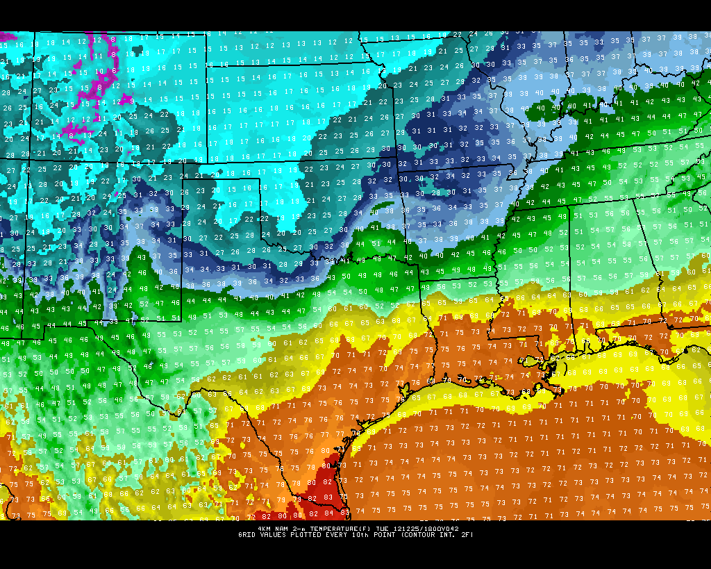
Christmas Day Forecast: Skies will turn mostly sunny by midday allowing for temps to climb into the 60s for early Christmas afternoon before an Arctic Cold Front blasts through the area mid-afternoon. Behind the front, winds will kick up out of the north northwest between 20-30 mph and temperatures will plummet from the 60s into the 30s by evening with temps falling into the 20s by Wednesday morning. Strong northerly winds combined with temperatures in the 20s will push wind chill values into the single digits and teens across the area by Wednesday morning. 

XMAS Day Hour by Hour Forecast:


NAM MODEL:

NOON:


6 AM WEDNESDAY MORNING:


GFS MODEL:

3:00 PM:


7:00 AM WEDNESDAY MORNING:


*THE NAM MODEL IS A BIT FASTER WITH THE FRONT WHILE THE GFS IS A BIT SLOWER...NEVERTHELESS, THE FRONT WILL ARRIVE SOMETIME BETWEEN NOON-4 PM CHRISTMAS DAY WITH RAPIDLY FALLING TEMPERATURES AND GUSTY NORTHERLY WINDS...KEEP IN MIND TEMPS WILL BE IN THE 60S AND 70S ACROSS CENTRAL AND SOUTH TEXAS WHILE TEMPS WILL BE IN THE 10S AND 20S ACROSS THE PANHANDLE AND OKLAHOMA CHRISTMAS AFTERNOON WITH SNOW FALLING!

Snow will be falling across Oklahoma and extreme North Texas for much of Christmas Day. Temperatures will be in the 10s and 20s across Oklahoma on Christmas Day with gusty northerly winds creating blizzard conditions across Oklahoma for XMAS Day. 

Latest high resolution snowfall models are indicating anywhere from 7-12 inches of snow across Oklahoma for Christmas Day...snow may fall as far south as the DFW Metroplex Christmas evening. However, accumulations will be on the light side with under 1 inch expected. Snow will stay well north of Central Texas.


Saturday, December 22, 2012

CHRISTMAS DAY COLD BLAST!!!

Hello everybody! Thanks to southerly winds we officially climbed to 69°F at both Camp Mabry and ABIA this afternoon after waking up to cold temperatures in the 20s and 30s across the area.

Tonight, under a mostly cloudy sky temps will only be able to fall back down into the middle to upper 50s. With a breezy southwesterly wind in place for Sunday, highs will climb into the middle to upper 70s area wide. A weak cold front will move through the area Sunday night, dropping highs back down into the 60s for Christmas Eve.

A strong upper level low pressure system will force a Pacific Front through Central Texas overnight Christmas Eve into Christmas morning; there is a 30-40% chance for showers and storms along that frontal boundary. Temps will remain in the 50s much of Christmas Day before the Arctic cold front hits and really drops temperatures. Behind the Arctic front Christmas afternoon, winds will pick up out of the north between 20-30 mph and gust as high as 40 mph at times. All of Central Texas will wake up to temperatures in the 20s by Wednesday morning with wind chills in the single digits and teens thanks to a gusty north wind.


Another big story with this storm system will be the chance for snow across extreme north Texas. Areas along the Red River and across northeast Texas have a good chance of seeing snow on the ground Christmas night! Oklahoma and Arkansas look to pick up the majority of the snowfall.


Highs on Wednesday will only make it into the lower to middle 40s across the area. North Texas will not get out of the 30s! Area wide hard freeze Wednesday night into Thrusday morning with lows falling into the teens and 20s. Bundle up and remember the 4 P's: People, Pipes, Pets, and Plants.

Here's a look at my latest seven day forecast. Looks like another Arctic Front set to arrive just after New Year's Day! Remember, you can always follow my Facebook page: Michael's Weather Center

Here's the link:  http://www.facebook.com/pages/Michaels-Weather-Center/137461949603151

Monday, December 17, 2012

TWO COLD FRONTS ON THE WAY!!!

Good evening everybody. What a beautiful day it has been. We officially climbed to 73ºF here in Austin after waking up on the chilly side with temperatures in the lower 40s. Tonight, under a clear sky, temperatures will fall back down into the upper 30s to middle 40s depending on your location and elevation. Of course, low-lying areas will see the coldest temperatures. 

I have some very exciting news for all of you cold weather lovers. We have two cold fronts on the way. Front #1 will push into the area Wednesday night allowing for chilly Canadian air to blast into Texas. Front #2 looks to be a lot more potent. Keep in mind, this forecast is over seven days out, therefore, things are likely to change. The second front which would move into Texas on or the day after Christmas looks to have the potential to drop highs into the 30s for a couple of days with lows falling into the 10s and 20s across the area. In fact, the GFS Model is showing a wintry precipitation event possible. Moisture will run over the cold air in place at the surface...snow and freezing rain would be possible in this set up. Keep in mind, this is still a long ways out and the forecast WILL CHANGE. 

First things first, we have a couple of warm days ahead of us for Tuesday and Wednesday.

 Highs on Tuesday will climb well above average across the area. I'm expecting highs to top out in the upper 70s to near 80ºF on a breezy southerly surface wind. The image above is a look at the high resolution NAM temperature model for Tuesday. South Texas will climb well into the 80s. In fact, this same model puts south Texas in the upper 80s on Wednesday. Tuesday night, clouds will increase with drizzle possible by Wednesday morning. Wednesday will be warm and humid with spotty showers and drizzle around. Highs will be in the 70s.

Wednesday night/early Thursday morning a strong Canadian cold front will blast through Central Texas and drop temps from the 70s Wednesday afternoon into the 30s by Thursday morning with wind chills in the 20s. Highs on Thursday will struggle back into the 50s on a strong northerly wind blowing between 15-25 mph. As winds relax Thursday night, temperatures will fall into the upper 20s to lower 30s across the area. 

It will be very windy behind the front on Wednesday night and Thursday as isobars will be very close to each other indicating a very tight pressure gradient. The closer together the isobars, the windier it is. 

Now, to the very interesting weather pattern that could possibly be shaping up for next week. Last night the European model began indicating an Arctic Blast would be possible for the day after Christmas. Today, the American Model is indicating the exact same thing. This would be the strongest front we have seen all season. Long range models are indicating showers and thunderstorms are possible ahead of the Arctic front with (get ready, sit down) SNOW possible behind the front! Please keep in mind this is a long ways out and the forecast is likely to change. What I will continue to look for over the coming days is model consistency. If models continue to indicate an Arctic Air outbreak for next week, the more confident I will become in forecasting a cold blast and possible wintry precipitation event. Highs would fall into the 30s and 40s with overnight lows falling into the 10s and 20s! Brrr!


Let's look at both of the models together. First, let's begin with the GFS (American Model):


The image above is a look at precip behind the front. North and northwest Texas would see snow with a cold rain/sleet mix possible here in Central Texas.

Now, let's look at the European Model:


The ECMWF is forecasting well below average temps for the middle to end of next week. Check out that purple bullseye across east Texas and Louisiana. WOW!

Sunday, December 16, 2012

EARLY LOOK AT CHRISTMAS

Good evening everybody. It sure was nice to see some rain this morning. Unfortunately, it didn't amount to much here in the city. Camp Mabry only picked up 0.05 inches of rainfall, however, the airport picked up 0.42 inches of rainfall. Areas off to the southeast of Austin faired a bit better. 

So, I'm sure you are all wondering what the weather is going to be like for Christmas. To be honest, I'm not very sure at this point. Two of the main forecast models I look at are telling two different stories. The GFS (American Model) keeps it relatively mild across Central Texas with highs in the 50s and 60s, however, the ECMWF (European Model) shows a strong Arctic front moving into Texas.

This is a look at the GFS Model for Christmas Day:


This is a look at the European Model for Christmas Day:


Keep checking back for more updates. As we get closer to the actual date I will have a much better grip on what is actually going to happen. 

Friday, December 14, 2012

TRACKING OUR NEXT COLD FRONT

Computer models continue to indicate our next blast of colder weather will arrive late Wednesday into Thursday of next week. Both the GFS (American) and the ECMWF (European) Computer Models agree on much cooler weather arriving here in central Texas for the second half of next week. Unfortunately, models show this front coming through the region without any precipitation. However, models do agree that this should be a very windy front. High winds and severe drought conditions get me worried for the risk of wildfires. 


This front looks to take temperatures from the 70s for highs back down into the 50s with overnight lows dropping back down into the 30s. Too early to say just how cold it is going to get or if we will see another widespread freeze across central Texas. Ahead of the front for Saturday-Wednesday temperatures will be well above normal in the 70s. In fact, some places may get close to 80ºF this weekend.

Ahead of the front temperatures will be well above normal, however behind the front temperatures will be below normal.

Ahead:

Behind:

This is a look at the GFS Model (focused on Texas):

Wednesday: Temperatures will climb well into the 70s


Thursday: Colder air arrives on gusty northwesterly winds


This is a look at the ECMWF Model (focused on Texas):