Thursday, October 26, 2017

October Cold Blast

Forecast Discussion

The strongest cold front of the 2017 fall season arrives early Friday morning. After a chilly start today in the 40s and 50s, afternoon highs were able to rebound nicely into the upper 70s - mid 80s area wide thanks to abundant sunshine, dry air, and a breezy south southwesterly surface wind. 

Current Temperatures across the Nation as of 5:00 PM CDT

Cold Front Timeline/Impacts

Friday

The cold front will arrive early Friday morning (before sunrise) with gusty northerly winds and falling temperatures. Afternoon "highs" on Friday will struggle to climb much above the upper 50s to lower 60s across the region. Breezy north winds sustained between 10-20 mph, frequently gusting 25-30 mph will make it feel even colder. While no substantial rain is in the forecast, a sprinkle or two cannot be ruled out (especially across northern areas of central Texas) Friday morning.

Highs | Upper 50s to Lower 60s

Friday Night 

Temperatures plunge into the 30s and lower 40s area wide late Friday night into Saturday morning...some areas north and west of the city of Austin may get within a degree or two of the freezing mark (32°F).

Lows | Mid 30s to Lower 40s

Saturday/Saturday Night/Sunday Morning

A chilly start to the day in the 30s and lower 40s will give way to a mainly sunny and brisk afternoon with afternoon highs climbing into the lower to middle 60s across the area before the bottom drops out once again Saturday night/Sunday morning as temperatures drop even further into the 30s across the area. The best opportunity for a freeze will come early Sunday morning for out-lying and low-lying areas across central Texas. Since cold air is more dense than warm air, on clear/calm nights the coldest air drains to the lowest lying locations (river beds, valleys, creek beds, etc.)...a freeze is NOT expected for Austin proper, although the airport may get very close because of their weather station's location near Onion Creek.

Highs | Lower to Middle 60s

Lows | Lower to Upper 30s; some low 40s in urban areas

Sunday & Beyond

After a very cold start to the day for late October, afternoon highs will rebound into the lower 70s with the help of a south southwesterly surface wind. Our next cold front and our next significant chance for showers and thunderstorms looks to arrive on Tuesday (Halloween).

Thursday, October 12, 2017

Warm End to the Week ahead of Sunday Cold Front

Forecast Discussion
After a brief taste of fall air earlier this week, above normal temperatures returned to central Texas Thursday afternoon. Surface high pressure moving to our east today allowed for south southeasterly surface winds to return. That shift in wind direction is bringing increasing moisture to the area this evening and warmer overnight lows. Highs climbed to 88ºF at Camp Mabry Thursday afternoon and 87ºF at Austin Bergstrom International Airport. Highs will remain in the upper 80s/lower 90s both Friday and Saturday under mostly sunny/partly cloudy skies. Overnight lows will remain mild in the upper 60s and lower 70s. 

The Forces Driving the Cold Front/Rain???
A developing trough of low pressure, or dip in the jet stream, will strengthen and cross the center of the country this weekend. That dip in the jet stream will push a cold front through the area Sunday morning. A moist air mass out ahead of the front will allow for a chance for scattered showers and thundershowers Sunday morning as the front sweeps through the region from the north. Given the fast-moving nature of this cold front, rainfall accumulation is looking to be rather light. Some locations may receive upwards of 0.25 inches of rain. Some folks may not see any rain as the front crosses their neighborhoods. 

Forecast Model Showing the Dip in the Jet Stream across the center of the country on Saturday

How Much Cooler???
A significantly cooler and drier air mass will filter into the area on Sunday on breezy/gusty north winds sustained between 10-20 mph and gusting between 25-30 mph. Skies will slowly clear from north to south through the day on Sunday before skies go completely clear late Sunday into Monday as temperatures drop into the 50s to lower 60s area wide by early Monday morning. It's going to feel great! This cool air mass will stick around through the middle of next week before warmer temperatures return by the end of next week.

Forecast Lows Next Tuesday October 17th 
40s and 50s area wide


Monday, October 9, 2017

Cold Front Arrives Tonight!

Forecast Discussion || Cold Front Arrives Tonight
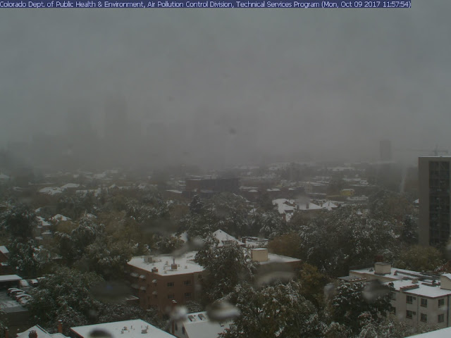
Our first significant cold front of the 2017 fall season arrives late tonight into early Tuesday morning. Latest indications are that the front will arrive between midnight to 3 a.m. CDT. There is a 30-40% chance for scattered showers and/or brief thunderstorms as the cold front pushes through the area generating lift (rising air). Behind the frontal boundary, a significantly cooler and drier air mass will invade the area from the north on breezy/gusty north winds. Winds will gust between 25-30 mph well into Tuesday morning. This same storm system is producing snow across Colorado today. Denver is currently a winter wonderland with between 4-6 inches of snowfall accumulation already being reported and it's still snowing. This is Denver's earliest reported snowfall in the past 5 years.

Denver Web Cam Shot taken at 1:00 p.m. CDT today (12:00 p.m. MDT):


Where is the front?
As of 1 p.m. CDT, the leading edge of the cold front is currently pushing through northwest Texas, just now reaching portions of the I-20 corridor. It's 55°F in Amarillo and 92° in Dallas.

Current Temperatures across the nation as of 1:00 p.m. CDT 


How much cooler?
Highs on Tuesday should only manage the 70s after starting the day in the 50s and 60s area wide. Lows Tuesday night into early Wednesday morning will dip into the 50s area wide with typically cooler locations dipping into the 40s. Highs on Wednesday should only manage the 70s to near 80 before the above normal temperatures return for the end of the week and the upcoming weekend. The average high/low for this time of year in Austin is 84/63.


Sunday, October 1, 2017

Rain Chances Returning

Forecast Discussion
Welcome to October! After a wet and dreary week, the sun finally came out this weekend across central Texas. Moisture will be on the increase as we start the new week. That increase in tropical moisture will lead to the chance for widespread showers and thunderstorms across the area on Tuesday and Wednesday. The clockwise wind flow around high pressure centered across the southeastern United States will allow for that tropical Gulf moisture to move into the area.

Rain opportunities Tuesday and Wednesday will be driven by daytime heating as there will be no focus (i.e. a cold front) for showers and storms to develop along. While I’m not expecting very impressive rainfall totals (generally between ½ to 1 inch of rain), some locally higher amounts will be possible for those locations that see more thunderstorm activity (rainfall rates higher in storms).


By Thursday, high pressure will begin to take control of our weather and allow for conditions to dry out and clear out.  

Long Range Outlook
The 8-14 day outlook courtesy of the Climate Prediction Center valid for October 9-15th is forecasting cooler than average temperatures and drier than average rainfall (see images below). True fall air may be right around the corner.

Temperature Outlook


Precipitation Outlook