Monday, December 22, 2014

Christmas Update

Forecast Discussion:

Good Monday evening everybody. I hope you all had a fantastic weekend. After a chilly, cloudy weekend southwesterly surface winds today in response to an approaching cold front and upper level disturbance allowed for temperatures to soar into the upper 60s and 70s across south central Texas today. We officially topped out at 77°F this afternoon at Camp Mabry (that's 15 degrees above the "normal" high of 62°F for this time of year).

A strong and deepening trough of low pressure across the center of the country will continue to build south into Texas tonight and into Tuesday. This deepening trough of low pressure will push a strong cold front and upper level disturbance across the area overnight tonight into Tuesday morning. This disturbance will be riding the outer periphery of the trough of low pressure (see image below).

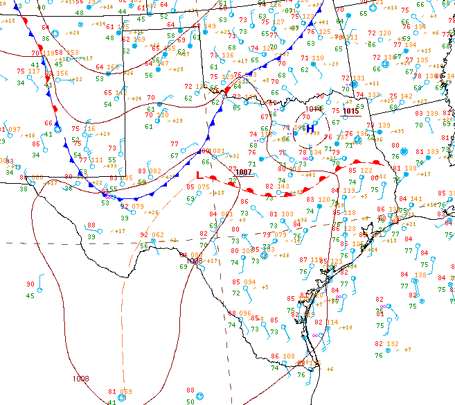
Current Location of the Disturbance:
Big Red "L" over Nebraska and South Dakota represents position of large upper level low...Red "Circle" indicates current position of upper level disturbance set to move through central Texas late tonight into Tuesday Morning...Red "arrows" represent the steering winds (Jet Stream)...the big trough over the middle of the country is clearly visible. The disturbance is currently producing light rain and snow across northeastern New Mexico and portions of the Texas Panhandle


As the disturbance crosses the area overnight tonight into Tuesday, showers and a rumble of thunder will be possible; highest rainfall chances will come for northern portions of south central Texas from the Austin Metro Area and points north all the way up into the Dallas/Fort Worth Metroplex and southern Oklahoma. Disturbance will be moving fast and rain that falls should be light. Given those two factors, rainfall accumulation will be very light (<0.15 inches). It wouldn't surprise me if we don't get more than a few sprinkles or very light showers around Austin Tuesday morning. 

Forecast Radar (8 a.m. Tuesday Morning)
Greatest energy with this disturbance looks to pass just north of south central Texas according to the latest high resolution NAM Model...Williamson County north to Dallas appear to have the best shot at seeing rain, of course if this system decides to track a bit farther south, rain chances would increase for us here in south central Texas


Forecast Accumulated Rainfall
Again, best rainfall chances look to move just north of the area...that's where the higher rainfall accumulations are likely to occur


In addition to the chance for rain across the area, MUCH COLDER weather will move in behind a strong early-morning cold front. Highs tomorrow (Tuesday) will actually occur after midnight ahead of the cold front. Cold front will arrive in the Hill Country first between 5-8 a.m. Tuesday morning. The front will then blow into the Austin Metro Area between 8-10 a.m. and should push through the remainder of eastern portions of central Texas between 10-11 a.m. Tuesday morning. Winds will be quite gusty behind the front sustained between 10-20 mph out of the north northwest with gusts between 25-30 mph likely. Our highs on Tuesday will be in the upper 50s (just after midnight) and drop into the 40s and lower 50s for the remainder of the day Tuesday behind the front. Breezy north winds and mostly cloudy skies will make it feel even colder. Especially since we saw temperatures in the 70s today. Clouds clear from northwest to southeast across the area late Tuesday into early Wednesday as the disturbance/cold front push east of the area. Areas of the Gulf Coast/Deep South may get some severe weather out of this system Tuesday afternoon/early Wednesday morning. The Storm Prediction Center has highlighted those areas in the map below.

Forecast position of Front 9 a.m. Tuesday Morning
Front will be pushing into the I-35 corridor (windy & much colder conditions can be expected behind front)


 Tuesday Severe Weather Outlook
Areas shaded in YELLOW have a 15% chance of seeing severe weather (Hail 1" in diameter or greater and/or winds of 58 mph or greater and/or a tornado)


Christmas Eve Forecast: Chilly start to the day with temperatures in the 30s area wide will give way to a SUNNY, BREEZY, AND CHILLY afternoon with highs only topping out in the upper 40s to lower 50s (48-53°F range)...a breezy north wind will ensure a brisk, chilly day for all of south central Texas. Temperatures Christmas Eve into early Christmas Morning will bottom out in the 28-34°F range. A freeze is likely for all low-lying and out-lying areas. The urban heat island effect will should keep the center of Austin a degree or two above freezing, however, low-lying spots within the city limits should prepare for a light freeze. 

Christmas Morning Forecast Lows


***IF WINDS REMAIN BREEZY DURING THE OVERNIGHT HOURS MORE LOCATIONS WILL REMAIN SAFELY ABOVE THE FREEZING MARK, HOWEVER, IT WILL STILL BE COLD WITH TEMPS IN THE 30s***

Christmas Day and after: COLD morning will give way to a sunny, cool and breezy afternoon with highs in the upper 50s to lower 60s across the area. Southerly winds will be blowing 10-15 mph with higher gusts. Southerly winds will keep temperatures well above freezing across the area Christmas Night into Friday morning in the 40s. Don't get me wrong, it will still be quite chilly with those breezy southerly winds. 

Sunny and pleasant on Friday after Christmas with highs in the mid to upper 60s area wide on southerly winds ahead of a late evening cold front that will blow through and cool us off for the weekend with highs dipping back down into the 50s for Saturday and Sunday. There is a slight chance for some showers late Friday into early Saturday with the front. A freeze is possible for low-lying out-lying locations Saturday night. 

Arctic Blast Possible Before New Year's

Long-range forecast models continue to indicate a significant change in the weather pattern as we head into the days before New Year's Eve. A strong ridge of high pressure is still forecast to develop across Alaska and northwest Canada. That ridge works to deepen low pressure to east and send lots of frigid, Arctic Air south into the lower 48. The long-range GFS Model shows temperatures running some 15-30 degrees COLDER THAN NORMAL for late December. New Year's Eve and New Year's Day have the potential to be pretty cold across central Texas with hard freezes possible. Still way too early to know for sure, but all forecast models continue to hint and indicate that we are in for some significantly colder weather to end the month of December and ring in the new year. Not just here in Texas, but across a good chunk of the central and eastern United States.

Forecast Temperatures for Midnight New Year's Day 2015-BRRR!!!


GFS Model forecasting a large swath of 15-30 degree below normal temperatures in the middle of the country later this month


Big Ridge (Red/Magenta Blob) forecast to develop over northwestern Canada/Alaska...that will send frigid air south into the lower 48


***Please understand that this blog post is just a forecast and is subject to change***

Saturday, December 20, 2014

December Roller Coaster

Weather Discussion:

With Christmas right around the corner, everybody wants to know what the weather is going to be like. To be honest, there are a lot of ups and downs over the next seven to ten days. As it looks right now, we have three separate cold fronts lined up to move through Texas between now and the end of the month. Each front looks to be progressively stronger.


We have been trapped under the clouds here along the I-35 corridor for the past several days now, however, portions of the Hill Country managed to see some this afternoon (check out the Visible Satellite Imagery from earlier today below). Clouds will hang on tough again tonight, but SHOULD slowly begin to break up and allow for some sun breaks by Sunday afternoon. A returning southerly wind flow and some afternoon sun will help highs temperatures climb 5-7°F across the area for Sunday after a chilly start to the day in the 40s. Highs Sunday afternoon will range from the upper 50s in the coolest locations to the lower 60s in the warmest spots. No rain is expected on Sunday, however, if clouds decide to remain stubborn highs will only make the upper 50s across central Texas.

Saturday Afternoon Visible Satellite Image of Texas: 
(Monochrome view of Texas from space this afternoon, yellow lines overlaid on top of the satellite image represent state and county outlines) 


As a strong and deep trough of low pressure builds down into Texas on Monday a surface area of lower pressure is expected to develop across north Texas. In response to the counter-clockwise wind flow around that area of surface low pressure our winds across central Texas will be out of the south southwest on Monday. The southwesterly component to the wind on Monday combined with strong southwesterly winds blowing around 4-5,000 feet above us will ensure a warmer day across south central Texas with highs climbing into the low to mid 70s under what should be a mainly sunny sky. If some stubborn low clouds were to stick around along and east of I-35, highs may only make the upper 60s. I mention this because a few of the latest forecast models want to keep some stubborn low-clouds around the area Monday.

Forecast Highs Monday (Snapshot of the NAM 4 KM High Resolution Model):
I've circled where the model believes low clouds could hang tough

  
The same deep trough of low pressure that will bring us the spring-like conditions on Monday afternoon will kick the surface low in north Texas to the east by early Tuesday morning. As that surface low is forced east by a strong disturbance riding the jet stream (river of fast-moving air) around the outer fringes of the trough, the door will open for a strong cold front to push through south central Texas Tuesday morning. A spotty light shower or two possible with the front as it crosses eastern portions of south central Texas, however, the majority, if not all of central Texas will remain dry. Strong northerly winds behind the front on Tuesday morning will knock highs into the 50s Tuesday afternoon under what should be a mostly sunny sky. North northwest winds sustained between 15-20 mph gusting to 30 mph will ensure a brisk feel to the day on Tuesday. Lows Tuesday night will drop into the 30s area wide. We will wake up to temperatures in the mid 30s right in Austin Wednesday (Christmas Eve morning). Areas north and northwest of Austin may receive a light freeze, however, a brisk north wind will not allow for a hard freeze.

Here's a look at what the GFS Forecast Model believes that trough of low pressure will look like on Tuesday over the center of the country...this map is for 500 mb (18,500 feet above sea level) The 500 mb level is extremely important in determining where weather systems (mid and upper level highs and lows) are headed: Can you spot the ridges and troughs? 


Deep South Severe Weather Threat: Ahead of that strong, deep trough of low pressure that will be over Texas on Tuesday, severe weather is possible for areas along the Gulf Coast and Deep South from Louisiana to Florida. The Storm Prediction Center is monitoring all areas shaded in yellow on the map below for the possibility of severe weather on Tuesday (December 23). For a fantastic, detailed look at the possibility of severe weather for the Deep South on Tuesday, click HERE

Storm Prediction Center Severe Weather Risk Area for Tuesday, December 23, 2014:
Stay up to date with the latest severe weather outlooks HERE.


Mostly sunny and pleasant on Christmas Eve after a cold start to the day with highs rebounding into the upper 50s to lower 60s...clear and chilly during the evening hours with temperatures quickly dropping into the 40s to lower 50s after sunset. Lows drop into the 30s to lower 40s area wide by Christmas morning. A returning southerly wind Wednesday night will help to keep the area above freezing. However, it is not out of the question for the lowest-lying locations across the area to receive a very light freeze. Sunny, beautiful and breezy on Christmas Day with highs in to the mid to upper 60s. Highs in the upper 60s to near 70°F for the Friday after Christmas ahead of our second cold front that is set to move through the region late Friday evening. As it looks right now, highs next weekend look to be quite chilly in the 50s with lows in the 30s. A fairly widespread freeze is possible across south central Texas next Saturday night/Sunday morning.

Looking towards the end of the month and into the new year, long range models continue to indicate a transition to MUCH COLDER weather across a good chunk of the lower 48. In their 8-14 day outlook, the Climate Prediction Center is indicating below normal temperatures for much of the lower 48 between December 26-January 3, 2015. Of course, this is a long range forecast and things are likely to change between now and then, overall it looks to be turning significantly colder for a good portion of the U.S. (including Texas) late this month into the new year. 

Climate Prediction Center 8-14 Day Temperature Outlook:
Click HERE to go to their website


A big ridge of high pressure is forecast to build across Alaska and northwestern Canada late this month...that ridge of high pressure helps to dislodge cold, Arctic Air and push it south into the lower 48. Big bulls eye of red and magenta over Alaska and northwestern Canada represents that big ridge of high pressure. That ridge of high pressure helps to deepen low pressure to the east of it and that dip in the jet stream is what pulls that frigid air south. Pretty cool, huh? Once that cold, dense air mass is tapped it is hard to stop it from pouring south into the lower 48...I like to think of those cold Canadian, and especially arctic air masses as bowling balls.


Monday, December 15, 2014

Keep the Umbrella Handy!

Weather Discussion:
We officially topped out at 74ºF this afternoon at both Camp Mabry and Austin Bergstrom International Airport. A much cooler air mass is settling into the region tonight and will set us up for a MUCH COOLER Tuesday and Wednesday. Lows will dip into the 40s across most areas tonight with some mid to upper 30s likely across the Hill Country. A chilly start to the day on Tuesday will give way to a mostly sunny and cool afternoon with highs in the upper 50s and lower 60s area wide. Clouds will be on the increase in a hurry from the west and southwest Tuesday afternoon and evening ahead of a quickly approaching trough of low pressure (elongated area of lower atmospheric pressure) currently affecting California and the desert southwest. 

The Big Red L represents the trough (TROF) of low pressure and the red arrow depicts its forecast track: For a really cool loop of this map in motion click HERE. This map depicts water vapor which basically shows mid and high level moisture in the atmosphere. The green lines are isobars (lines of equal atmospheric pressure) and are drawn on to help find areas of high and low pressure around 18,500 feet above the earth's surface.


Rain is a good bet on Wednesday as warm, moist air rides over the cooler air here at the surface thanks to the approaching trough. Get ready for a dreary, chilly and showery day on Wednesday with temperatures likely to stay in the 40s and 50s all day. Rain on Wednesday will be light to moderate in intensity. This is not the right weather set-up for big storms or heavy rainfall. Dense fog may become an issue late Wednesday into Thursday morning as much warmer air from the south advects north into central Texas. That warmer air will push highs back into the lower 60s ahead of another area of low pressure that will push across Texas from west to east Thursday and Friday. Good chance for showers on Thursday with some heavier showers and possible thundershowers Thursday night into early Friday morning ahead of a cold front that will usher in more chilly air into the area from the northwest and clear out our skies on Friday afternoon. Highs hover into the 50s to near 60ºF Saturday through Monday of next week with lows in the upper 30s and 40s. More light rain possible early next week with another weather system from the west. Latest model guidance showing a mild Christmas Eve and Christmas Day with highs in the 60s, possibly low 70s ahead of a strong cold front that would push through the region late Christmas Day into the day after Christmas. (Please keep in mind this is a very early look at the Christmas forecast. Weather has a mind of its own and this is only one model's take on what is going to happen). 

Here's a look at Forecast Simulated Radar Reflectivity for 3 P.M. Wednesday afternoon:


Latest forecast guidance is forecasting 1/2 to 1 inch of rain to fall across a good portion of central Texas between Wednesday morning and Friday afternoon. Keep your fingers crossed that these forecasts verify. We can use every drop we can get here in central Texas. No freezes likely between now and Christmas Eve...that may not be the case for the days after Christmas if latest model data verifies. The Weather Prediction Center is forecasting a good 1-2 inches of rainfall falling across a good chunk of central Texas over the next 5 days (see image below): 


Friday, December 12, 2014

Weekend Storm Chance/Early Look at Christmas

Upper level storm system currently affecting the west coast of the United States will continue to push east over the weekend and affect us here in Texas by Sunday. Warm and mild weekend in store with highs in the lower to middle 70s and lows in the upper 50s to near 60°F. Southerly winds will begin to pick up across the area Saturday afternoon and will be rather breezy on Sunday ahead of the storm system moving into the state. Spotty sprinkles or a very light rain shower are possible Sunday morning. Highs Sunday afternoon will make the lower 70s ahead of a Pacific Cold Front that will work its way through the area from west to east during the afternoon and evening hours. The warm, moist air out ahead of the front will be forced to rise in turn giving us a 50% chance for showers and thunderstorms on Sunday afternoon/evening, possibly lingering into the early morning hours on Monday depending on how quick this weather system pushes through the area. Some of the storms that develop on Sunday will have the potential to become strong with heavy rain and deadly cloud to ground lightning. The severe weather threat on Sunday is not zero, however, it is not very likely. With that mentioned, the Storm Prediction Center has placed a large swath of the central United States from Kansas south into central Texas under the MARGINAL RISK category for severe weather. What this means is that there is a 5% chance that any location in central Texas from Austin north will see severe weather. A thunderstorm is defined as severe when it produces hail quarter size (1 inch in diameter) and larger, and/or winds of 58 mph or greater, and/or a tornado. 

STORM PREDICTION CENTER MARGINAL RISK AREA FOR SUNDAY:
Click HERE to go the Storm Prediction Center's Website


Quick refresher on watches/warnings issued by the National Weather Service and Storm Prediction Center as defined by the National Weather Service:

WEATHER WATCH: atmospheric conditions are FAVORABLE for the type of weather specified (generally issued for a larger geographic area for a longer time span; 4-6 potentially up to 24 to 48 hours)

WEATHER WARNING: the type of weather specified is IMMINENT/OCCURRING and is and an immediate threat to life and/or property (smaller geographic area; shorter time span of 1/2 to 1 hour)...proper action should be taken to protect life and/or property. 

FORECAST RADAR FOR SUNDAY EVENING (NAM FORECAST MODEL):
Model forecasting a line of storms to develop from Kansas all the way south into central Texas along the frontal boundary (I'm expecting rainfall totals between 0.25 to as much as an inch in spots across the area thanks to Sunday's storms. Some areas may receive significantly less. It all depends on how solid the line of storms is when it moves through the area. If there are lots of gaps in the line of storms, as I'm expecting there will be, many folks may be left with little to no rainfall accumulation---Hope I'm wrong)


Long Range Outlook:

Cooler weather moves in behind the front on Monday with highs dropping into the 60s for highs; 40s expected across the area Monday night/Tuesday morning of next week. Clouds quickly increase across the area by Tuesday of next week ahead of another weather disturbance that will bring us several days of light rain chances by the middle/end of next week. Highs only in the 50s Tuesday/Wednesday with light rain possible Wednesday through Friday ahead of another front that as or right now, looks to drop highs into the 50s for the days leading up to Christmas with lows in the 30s and 40s...the general pattern for Christmas week looks cooler with some long range models predicting a possible freeze after Christmas Day. Of course, forecasting that far out in the future should be taken lightly and please understand that nothing is set in stone when it comes to the weather. 

Friday, November 21, 2014

Severe Weather Threat Saturday

FORECAST DISCUSSION:
As a potent upper level low pressure system moves across central Texas on Saturday showers and thunderstorms will become likely. Some of the storms that develop will become strong and/or severe with hail, damaging winds, and even the possibility for a few isolated tornadoes. The Storm Prediction Center (SPC) has placed all of central Texas under the SLIGHT RISK category for severe weather on Saturday. What this means is that any one location in central Texas has a 15% chance of seeing severe weather. Along with the threat for severe weather, there is the potential to see a widespread 1-2 inches of rain across the area with highest totals expected to be found along and east of the Interstate 35 corridor.

SLIGHT RISK=YELLOW SHADED AREA:


As the upper level storm system approaches Texas from the west, it causes air to converge, rise, and diverge aloft. Warm, humid air at the surface is forced to rise into significantly colder air aloft allowing for thunderstorms to develop. In the northern hemisphere, areas of low pressure spin counter-clockwise. At the surface, this upper level storm system will be pushing a Pacific Frontal Boundary across the state. Ahead of this frontal boundary is where the showers and thunderstorms will form. Once the front clears the area by late Saturday evening, the storm threat will diminish and skies will clear from west to east as much drier and more stable Continental air mass (air that originates over the desert southwest and the deserts of northern Mexico) moves into the area. West southwesterly winds on Sunday will allow for highs to climb into the mid to upper 70s area wide under a mainly sunny sky. 

Storm System as seen on Water Vapor Imagery (Red L=storm's location Friday evening): 


Water Vapor Imagery Loop: Can you spot the counter-clockwise rotation south of Arizona? That's the upper level low!!


FORECAST RADAR IMAGERY (NAM 4 KM HI-RES MODEL):
***WAVES OF STRONG/SEVERE STORMS DURING THE DAY SATURDAY WILL BE FOLLOWED BY A LINE OF STRONG/SEVERE STORMS DURING THE EVENING HOURS AS THE PACIFIC FRONT CROSSES THE AREA FROM WEST TO EAST***
(Loop starts at 9 a.m. Saturday and runs through Sunday Midnight)


***PLEASE STAY WEATHER AWARE DURING THE DAY ON SATURDAY AND KEEP AN EYE TO THE SKY*** 

WEATHER TIMELINE: 

Friday Night: Increasing chances for showers and thunderstorms as upper level low continues to move closer to Texas; a few strong storms are not out of the question with the main threats from those storms being heavy rain, lightning, and gusty winds. Mild with lows in the 60s with a south wind; 60% chance of rain

Saturday: Thunderstorms likely; some of the storms that develop will become severe with large hail, damaging winds, and possibly an isolated tornado or two...we are likely to see several rounds of storms during the day. Highs will be in the lower 70s; 100% chance of rain

Saturday Night: Pacific Front moves through the area during the late evening hours putting an end to storm chances; skies clear overnight from west to east as drier air moves into the region. Cooler with lows in the 50s

Sunday: Sunny, breezy and warm with highs in the mid to upper 70s! Enjoy!

Sunday Night: Cold Front moves through the area dropping lows into the 40s under a mostly clear sky

Monday-Friday of next week: Sunny/clear with highs in the 60s and lows in the 30s and 40s...beautiful fall weather! Enjoy!

SEVEN DAY FORECAST:


Friday, November 7, 2014

Early Season Arctic Blast Next Week!

TGIF everybody! There is a lot to talk about in the weather department so let's get right to it. The rain that we saw over the last several days was a very welcome sight and overall a beneficial rain for central Texas. Unfortunately, it is going to take a lot more rainfall events like that to fill up the Highland Lakes. Everybody in central Texas picked up over an inch of rain with several locations receiving 2-4 inches of rain. 

A really cool way to check out rainfall totals from the area is through the LCRA's Hydromet Network. Use the menu on the left-hand side of the website to display lots of different data from across the region, including temperature, rainfall, humidity, and lots more. Click HERE to access the website. It works just like any other Google Map application so feel free to zoom way down to your neighborhood. 


NEXT WEEK'S ARCTIC BLAST:


Would you believe it if I told you the Arctic Air getting ready to be unleashed on the central and eastern U.S. next week can actually be attributed to what was once Super Typhoon Nuri, the equivalent of a category 5 hurricane that moved through the western Pacific earlier this week, just east of Japan. As Nuri continues to move farther north into colder waters of the northern Pacific it has transitioned from being a warm-core low pressure system to a cold-core low pressure system, basically Nuri has lost its tropical characteristics. Meteorologists refer to a tropical cyclone that loses its tropical characteristics as an extra-tropical cyclone. As extra-tropical cyclone Nuri crosses the northern Pacific it is forecast to greatly strengthen thanks to a strong jet stream and is likely to go down in history as one of the most powerful low pressure systems to every develop in the Pacific and it has its eye set on Alaska. Weather historian, Christopher C. Burt, says the all-time low pressure record for Alaska is 926 mb set back at Dutch Harbor on October 25, 1977. Extra-tropical Nuri has a good chance of beating that record if its center passed over the Aleutian Islands of Alaska on Saturday morning. Hurricane force winds and very rough seas, with waves as high as 45-50 feet possible across Alaska's Aleutian Islands.


Super Typhoon Nuri earlier this week (South of Japan): Photo was taken November 4th


Okay, so how is this going to affect us here in Texas. Well, this unusually strong area of low pressure will amplify a ridge of high pressure over the eastern Pacific and across the west coast of the United States to build way into the Alaska, the Arctic Circle and northwestern Canada. As that ridge of high pressure amplifies it will allow for a trough of low pressure to deepen to its east across central Canada and the lower 48...this unusually strong ridge of high pressure to the west and strong trough over much of the U.S. will help to pull very cold Arctic air from the Arctic Circle and even Siberia down into the central and eastern U.S. early next week.


Weather Set-Up (Described in paragraph above):


FRONT'S ARRIVAL/DAY BY DAY FORECAST


The much anticipated cold front will arrive in central Texas early Tuesday morning (Veteran's Day Morning). Ahead of the front on Monday, southwesterly surface winds will push highs well into the 70s across the area.


MONDAY: Mostly sunny, mild, and breezy with highs in the mid to upper 70s; SSW wind 10-20 mph


TUESDAY: Arctic Front pushes through central Texas between midnight to 7 a.m. The front will likely sweep through the area dry as moisture levels across the area will not be sufficient to produce rain...strong northerly winds develop quickly behind the front keeping temperatures in the 50s all day on Tuesday under a mostly sunny sky...north winds will be kicking 15-25 mph with gusts over 30-35 mph likely.


GFS Model Showing Front arriving early Tuesday Morning:


TUESDAY NIGHT: Clear, cold and gusty with temperatures dropping into upper 30s to lower 40s across the area


WEDNESDAY: COLD morning with temperatures in the upper 30s and lower 40s (wind chills in the lower 30s). Highs will struggle to reach the lower 50s across the area with some locations not getting out of the 40s under a mostly sunny sky.


WEDNESDAY NIGHT: Lows drop into the 30s area wide (a few locations across the western and northern Hill Country may receive a light freeze) Temps: 34-39°F


GFS Forecast Lows Wednesday Night: 


THURSDAY: Sunny and chilly with highs in the upper 40s to lower 50s


THURSDAY NIGHT: Lows drop back into the 30s; low-lying spots may get a light freeze


Thursday Night Forecast Lows: 


Warming trend takes highs back into the upper 50s to lower 60s next weekend. Long range models indicate a second blast of Arctic Air possible by the beginning of the week after next, but I'll have to continue to watch for model consistency.


Friday, October 10, 2014

The Tale of Two Fronts

TGIF Everybody! We have got a little bit of everything in this weekend's forecast. We officially set a brand new record high of 93ºF at the airport today beating the previous record of 91ºF set back in 1999. A trough of low pressure pushing east over Texas combined with a surface cold front will give us a good chance for widespread showers and thunderstorms beginning late tonight through Saturday morning. The cold front I am watching is currently draped across the Big Country, just northwest of the San Angelo area. This front will continue to push towards the southeast tonight into early Saturday. I'm expecting a line of storms to develop along and just behind the frontal boundary as it moves through central Texas early Saturday morning. Strongest storms tonight will be capable of gusty winds to 50 mph, frequent cloud to ground lightning, heavy rain and small hail. 

Simulated High Res Radar Reflectivity: 


Cooler weather will move in behind the storms on Saturday with highs only expected to be in the 70s; northerly winds behind Saturday morning's front will quickly turn back out of the south by late Saturday night and set us up for our next chance of storms on Monday. There is a slight chance for a brief shower on Sunday, but the highest rain chances will hold off until Monday morning. Highs will be in the 80s on Sunday. Monday's storms will develop ahead of a strong upper level storm system (trough of low pressure) and its attendant strong cold front. Storms that develop early Monday morning along the front will have the potential to become severe with strong gusty winds being the main threat. Windy, drier, and much cooler behind the front on Monday with highs in the 70s! Beautiful stretch of weather expected next week behind Monday's cold front with chilly mornings in the 40s and 50s and warm afternoons in the 70s and 80s under a beautiful blue sky. 

Forecast Trough of Low Pressure over the central US on Monday:


Monday, July 14, 2014

July Cold Front

Hello everybody and thank you for checking out my blog. After two consecutive days of triple digit heat, some temporary relief is on the way. A strong July Cold Front, currently pushing into north Texas at this time will stall out over central Texas during the day on Tuesday. While the front will not provide us much in the way of a cool down, it will be the focal point for showers and storms to flare up during the afternoon and evening hours. Converging winds along the frontal boundary allow for the warm, moist air in place over central Texas to rise and in turn produce storms. Afternoon highs on Tuesday are highly dependent on just how much sun we see and where/when storms begin to erupt. There is a 50% chance for storms on Tuesday. Given atmospheric and surface conditions, storms that develop will have the potential to become quite strong with gusty winds, heavy rain and deadly cloud to ground lightning. Highs will likely make the mid and upper 90s briefly Tuesday afternoon before storms develop and cool areas into the 70s and 80s thanks to cooling thunderstorm outflow winds. Those outflow winds in turn help other storms to develop; you can think of outflow winds/boundaries as mini cool fronts.

Latest Surface Analysis showing the frontal boundary (blue line with southward facing triangles) pushing through southern Oklahoma:


Unfortunately for us here in central Texas, none of the cool, dry air behind the front will make it here to Texas, however, areas as far south as the southeastern United States will get an early taste of Fall in July

Forecast Highs across lower 48 on Tuesday, check out all of those 70s on the map! Much of the midwest and central plains will be waking up to temperatures in the 40s and 50s Tuesday morning. Doesn't that sound refreshing!!


Temperatures will be running a good 5 to as much as 25 degrees below normal for this time of year behind this unusually strong July Cold Front:


High pressure centered off to our west over the desert southwest and a large trough (elongated) area of low pressure (responsible for the rare July Cool Blast) to our northeast will keep a northwesterly wind flow over much of Texas through the end of the week. As the frontal boundary begins to drift back north as a warm front by Wednesday and Thursday and upper level disturbances approach from the northwest, it is not out of the question for large storm clusters to develop over north and northwest Texas and track south southeast into central Texas. These storm clusters are known as Mesoscale Convective Systems (MCS's). An MCS is basically a large cluster of storms that has the potential to travel for long distances and provide heavy rain and possible severe weather over large areas. The Storm Prediction Center has placed portions of northwest Texas, including the city of Lubbock, under the SLIGHT RISK category for severe weather on Wednesday [see image below]...storms that develop in that area will have the potential to merge into a complex of storms and affect us here in central Texas late Wednesday into Thursday and again on Thursday into Friday. We will have to wait and see how all of this plays out.


Given our chances for showers and storms over the coming days, highs will remain below the triple digits through the end of the work week. 

The Weather Prediction Center is forecasting anywhere from 1/2 an inch to as much as 2 inches of rain to fall across portions of central Texas over the next five days. Keep your fingers crossed as we can use every drop we can get. Heaviest rains are likely to fall well north and northeast of central Texas where this particular forecast is calling for as much of seven inches of rain to fall over southeastern Oklahoma, northeastern Texas and southern Arkansas over the next five days. 


***For more frequent weather updates please LIKE my Facebook Page, Michael's Weather Center, and/or follow me on my Twitter Account, WeatherMinute***

Thursday, June 12, 2014

Severe Threat Today

Good Afternoon everybody. I hope you are all doing well. I just wanted to send out a quick weather update to inform you all on what has the potential to be a rather stormy late afternoon/evening around central Texas. Several factors are coming together to make the atmosphere prime for severe weather later this afternoon and into the evening hours. The Storm Prediction Center out of Norman, Oklahoma has placed a large portion of Texas, including central Texas, under the SLIGHT RISK CATEOGRY for severe weather today. Much of Central Texas, including the Austin Metro Area, has been placed under an enhanced risk for severe weather this afternoon. Storms that develop will have the potential to turn rapidly severe with extremely large hail, ranging from the size of dimes to as large as baseballs, damaging winds in excess of 60 mph, torrential downpours, and thousands upon thousands of strikes of deadly cloud to ground lightning. The Storm Prediction has even mentioned that a tornado or two is not out of the question this afternoon. 

RISK AREA (ENHANCED RISK SHADED IN RED):


I’m putting the chance for thunderstorms this afternoon/evening at 50%. That means that anywhere in central Texas has a 50% chance of seeing a thunderstorm today. Of course, it is hard to pinpoint exactly where these storms will develop, however, the most likely point for storm initiation will be the far western and northwestern Hill Country (these storms that develop will have the best potential for producing hail up the size of baseballs and possibly a tornado or two), however, that is not to say that large hail and an isolated tornado is out of the question for the I-35 corridor.

TODAY'S WEATHER SET-UP:

See Image Below:
A weak cold front (currently located in northwest Texas, that’s the blue line with the blue triangles). That cold front is located near an area of surface low pressure which is dragging plenty of rich, gulf moisture into central Texas as evidenced by dew points in the 70s! That is south Florida air! Just ahead of the cold front is the dry line which separates moist Gulf Air to the east of it from dry desert air to the west. As these features approach the area from the west this afternoon, combined with a quick moving disturbance in the upper levels of the atmosphere, severe storms are likely to develop. While there is a fairly strong cap in place, a layer of warm, dry air around 5-8,000 feet above the surface, sufficient daytime heating and lift should allow for storms to erupt given the strong cap in place. The intensity of the storms is all going to depend on how much sun we see and how hot we are able to get. Areas to our southwest along the Texas-Mexico border will be well into the 100s this afternoon with temperatures approaching 110°F in a few locations.

LATEST SURFACE ANALYSIS:


The area of high pressure that was parked over us much of last week and the past couple of days has retreated back to our southwest into northern Mexico. The clockwise flow around high pressure develops a west and northwesterly wind above Texas around 18,000 feet into the atmosphere. Those steering winds will pull storms that develop to our north and west into our area. Think about the winds as a river of air, embedded within that river are ripples (a.k.a disturbances) that produce lift in our atmosphere.

NORTHWEST FLOW GRAPHIC:


FORECAST RADAR:


Wednesday, June 4, 2014

Early June Outlook

Hello everybody! Meteorological summer officially started on Sunday (June 1st). With a ridge of high pressure firmly in control of our weather after last week’s wonderful rains things have been quite boring around here with the typical morning clouds giving way to partly sunny, warm, and humid afternoons. Honestly, that pattern looks to continue through the weekend. Slight rain chances look to enter the forecast by Sunday Night and persist through the first half of the day on Tuesday of next week. The ridge of high pressure that is currently dominating our weather will briefly break down by late this weekend and shift to our southwest. That puts a northwesterly flow across Texas in the upper levels of the atmosphere (around 18,000 feet), meaning winds will be blowing from northwest to southeast across the state.

This northwesterly flow is important because storm complexes that develop across far northwestern portions of the state are forced to move towards the southeast into both north and south central Texas. This is a very common early summer set-up. If those storm complexes that develop several hundred miles to our north are able to survive the trip south, they have the potential to bring us some good rainfall as well as a slight risk of severe weather, mainly in the form of strong damaging winds and lightning. Until then, expect more of the same with cloudy, warm and humid nights in the upper 60s and lower 70s giving way to partly cloudy, warm, and humid afternoons with highs in the upper 90s. Thanks to last week’s drenching downpours the soil is still quite moist which has helped to keep afternoon highs quite a bit lower than they could be for early June. However, as that soil moisture begins to dry up temperatures will begin to soar. These northwest flow thunderstorm events are hard to predict this far out, stay up to date with all of the latest weather developments on my Facebook Page: Michael's Weather Center and my Twitter account: WeatherMinute (Just click the names of my pages to access them).

Northwest Flow Graphic:


Last week’s rains have helped the drought across the area somewhat, especially for areas along and east of Interstate 35 where drought conditions have dropped into the abnormally dry and moderate drought categories. A large portion of the Hill Country is still stuck in Extreme Drought Conditions and areas southwest of the Hill Country towards Del Rio are stuck in the Exceptional Drought Category (the worst type of drought).

Latest Drought Monitor:


Both lakes Buchanan and Travis are 39% full and currently hold about 788,463 acre-feet of water, according to the LCRA. The surface of Lake Travis is currently sitting at 629.23 feet above sea level and the monthly average for Lake Travis this time of year is closer to 670.01 feet above sea level. Lake Travis is over 40 feet below average!! Unfortunately, the Climate Prediction Center is forecasting drought conditions to persist and intensify across a good chunk of Texas and Oklahoma as well as southern Kansas between now and the end of August. The three month temperature outlook is forecasting above normal temperatures through the summer with equal to below normal chances for rain.

Drought Outlook:


3-Month Temperature Outlook:


Given a possible developing El Niño, NOAA (The National Oceanic and Atmospheric Administration), is forecasting a near normal or below average hurricane season. They are predicting three to six hurricanes to form in the North Atlantic this season. Keep in mind, the season could be an active one even though the forecasts are forecasting differently. Accuweather is forecasting areas from the central and eastern Gulf of Mexico up through the East Coast will be most vulnerable for impacts from a tropical storm. It is going to take a persistently wet fall and winter or a major rainmaker from the Tropics to help us with our drought situation.  

Thursday, April 10, 2014

April Weather & Drought Update

Hello everybody! What a beautiful past couple of days it has been, minus the gusty winds and the loads of pollen in the air. We officially topped out at 87ºF this afternoon at Camp Mabry and 86ºF at the airport. Southerly winds will ease a bit overnight, however, they will stay breezy and ensure widespread clouds late tonight into Friday morning. Those clouds will gradually break up by Friday afternoon and allow for a partly sunny, breezy, and more humid day with highs topping out in the mid 80s. Persistent southerly flow off of the Gulf will ensure a warm, breezy, and humid weekend with cloudy/drizzly mornings and partly sunny afternoons. Highs will be in the 80s with lows in the 60s on Saturday and Sunday.

Risk Area for Severe Weather on Sunday (RED shaded area):
CLICK HERE TO VIEW CURRENT SEVERE WEATHER OUTLOOKS, WATCHES, AND MUCH MORE!


An upper level disturbance will push the west Texas Dry Line (the boundary that separates dry desert air from humid Gulf air) into the far western Hill Country Sunday afternoon. This boundary will be the focus for a storm or two to develop late Sunday afternoon. Although the storms are likely to be isolated in nature, they have the potential to become severe in a hurry with large damaging hail and strong gusty winds. The best chance for severe weather on Sunday will be north and east of Central Texas as the heart of the disturbance will pass just north of us. Once the disturbance passes to our east, it will open the door for a strong cold front to blast through the area late Sunday into early Monday. There is another chance for storms along the front late Sunday into early Monday morning.

Sunday's Upper Level Disturbance:


Behind the front on Monday, it will be considerably cooler and drier across the area as strong northerly winds will only allow for highs in the 60s and lower 70s on Monday. Lows Monday night will drop into the 30s and 40s! Our next chance for storms will arrive Thursday of next week.

Monday's Cold Front (check out that temperature difference!):
40s & 50s behind the front, 70s ahead of the front!


With the lack of rainfall around here, the drought is continuing to worsen. Here's the latest from the U.S. Drought Monitor:

  • The Hill Country has dropped back into EXTREME drought conditions, the second-to-worst drought category
  • The remainder of central Texas, including the Austin Metro Area, is experiencing MODERATE drought conditions. 
  • According to the LCRA, both Lake Buchanan and Lake Travis are only 37% full
  • Click HERE to visit LCRA's Drought Page
  • Click HERE to visit the U.S. Drought Monitor's Website
  • Click HERE to view the devastating effects of the drought on Lake Travis
Lake Travis March 2014
PHOTO COURTESY OF THE LCRA


Latest Drought Monitor for the state of Texas:
64% of the state is currently in a drought and nearly 30% of the state is in the EXTREME and EXCEPTIONAL drought categories.


Lots of people have been asking me about our upcoming summer. If we do not receive a lot of good beneficial rainfall this spring, it is likely to be another scorchingly hot summer. The less moisture we have in the ground, the faster it heats up around here. El Niño is forecast to return come Fall/Winter of 2014-15, however, that is a long way's off and things may change. El Niño brings brings us (Texas) cooler & wetter than normal conditions. La Niña brings us warmer and drier than normal conditions.

The latest 3 Month Outlook from the Climate Prediction Center is forecasting WARMER than normal weather for a large section of the western and southern United States.