Saturday, December 26, 2015

Severe Threat Tonight/Sunday

Weather Alert: The Storm Prediction Center in Norman, Oklahoma has placed a large portion of north and south central Texas under an ENHANCED RISK area for severe weather through Sunday morning. 

Severe Weather Risk Areas through 6 a.m. Sunday Morning:


Severe Weather Risk Areas after 6 a.m. Sunday Morning:


>According to the Storm Prediction Center, an ENHANCED RISK of severe weather means numerous severe storms are possible...the severe storms that are able to develop will be more persistent and/or widespread...a few of those severe storms may become intense potentially producing a few tornadoes, and/or several reports of wind damage, and/or damaging hail of 1-2 inches in diameter.


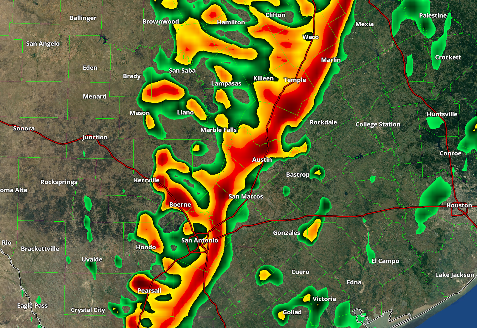
>The Storm Prediction Center (SPC) has issued a TORNADO WATCH for a large portion of north central and north Texas into southeastern Oklahoma through 8 p.m. this evening. This watch does include Temple/Killeen, Waco, and Dallas/Fort Worth.


Tornado Watch Details:
>The SPC warns that a few tornadoes will be possible within and in the vicinity of the watch box, along with the potential for some isolated large damaging hail and some isolated damaging thunderstorm wind gusts to 70 mph.

>>>No watches/warnings are currently in effect for south central Texas, however, the SPC is monitoring our area closely. As of their latest forecast discussion, the SPC is giving our area a 40% chance of being placed under a weather watch over the next several hours. 

Evening/Overnight Forecast:
Scattered storms will continue to develop and move north across the area through the evening and late night hours...some of the storms that develop will become strong/possibly severe with heavy rainfall, lightning, gusty winds, some small hail, and perhaps a tornado or two. The atmosphere is ripe for severe weather and wind profiles are favorable for rotating storms to develop which may in turn allow for a tornado or two to spin up. Please keep an eye to the sky and have a way of receiving the latest watches/warnings issued by the National Weather Service. If you have turned off the severe weather alerts on your smart phones, now would be a good time to turn those back on...they may end up saving your life!

Southerly winds will remain breezy through the evening and may actually increase overnight tonight as the weather system approaches the area...think of these moist, southerly winds as fuel for the storms this evening and overnight and into Sunday morning.

Warm & moist southerly winds off of the Gulf will keep temperatures warm across the area through the overnight hours in the 70s...big temperature drop arrives behind the front Sunday morning!

Severe Weather Risk:
Our risk of severe weather is developing ahead of a potent upper level Pacific storm system and its associated Canadian Cold Front. As this system approaches and moves through the area late tonight into Sunday morning widespread showers and storms will develop. Some of the storms will have the potential of becoming severe. As the cold front moves through the area early Sunday morning, I'm expecting a line of strong storms to push from west to east across the region. This line of storms will have the potential to bring many locations within south central Texas strong wind gusts and heavy rainfall.

MUCH COLDER AIR moves in behind this weather system and cold front on Sunday with lows dropping into the 30s area wide by Monday morning!

Let's continue to remain weather aware!

Tuesday, December 22, 2015

Warm and Unsettled Christmas Week

Forecast Discussion:
Good Tuesday afternoon everybody. Abundant sunshine and a warm southwesterly, down-sloping wind above the surface has allowed for another well above average afternoon across south central Texas. We officially topped out at 79°F at Camp Mabry this afternoon (17 degrees above the average high of 62°F for this time of year) and 78°F at the airport (15 degrees above their average high of 63°F for this time of year). In fact, we came very close to tying the record highs at both official weather stations this afternoon...record high for this date at Mabry is 81°F set back in 1941 and 80°F at the airport set back in 1988.

Tonight/Overnight:
>>>Southerly surface wind flow increasing across the area this afternoon in response to an approaching upper air disturbance from the west. The tail end of the upper level energy with this system will skirt the area overnight and allow a weak Pacific frontal boundary (dry line) to move through the area overnight.

>>>Widespread low clouds with embedded areas of mist and/or drizzle likely across the area late tonight into early Wednesday morning ahead of this approaching weather system. A few scattered light rain showers will be possible here across south central Texas with the potential for some heavier downpours and brief thunderstorms north of our area. An isolated heavy downpour or thunderstorm cannot be completely ruled out late tonight/early Wednesday morning for areas along and east of the I-35 corridor as the Pacific Front/Dry Line crosses the area.

>>>Lows tonight will be significantly warmer across the area thanks to the southerly wind flow off of the Gulf across the area. Lows tonight will actually be warmer than our average highs for this time of year in the mid to upper 60s.

Forecast Clouds/Radar at 1 a.m. (HRRR Model)


Image above courtesy of Penn State Department of Meteorology 

Wednesday's Forecast:
>>>Widespread morning low clouds, drizzle, and scattered rain showers will give way to a mainly sunny, drier, and warmer Wednesday with highs easily expected to climb into the upper 70s to near, if not exceeding, the 80°F mark in a few locations. The west southwesterly wind and dry air behind the dry line will allow for temperatures to warm up nicely. Wednesday night/Christmas Eve morning will be cooler thanks to the drier air in place with lows expected to dip into the upper 40s to lower 50s across the area...some patchy areas of fog may develop by Christmas Eve morning (especially for areas south and east of Austin).

Enhanced risk of severe weather across the southeastern United States (hail, damaging winds, and tornadoes all possible, especially in areas shaded in orange on Wednesday)...just a head's up if you or anyone you know is traveling in that direction tomorrow


Christmas Eve (Thursday) Forecast:
Gulf moisture quickly returns to the area as a deep trough, or dip in the jet stream begins to set up across the western United States...return flow off of the Gulf will allow for moisture to come surging back up into the area and keep highs well above average for this time of year. Highs will easily manage the mid to upper 70s. A few light rain showers will be possible across the area, especially during the evening hours as southerly surface wind flow increases in response to dropping surface pressure across the plains.

>>>Highs: Mid to Upper 70s
>>>Lows: Upper 50s to lower 60s

Christmas Day (Friday) Forecast:
Cloudy and mild start to the day with temperatures near 60°F gives way to a mostly cloudy, warm, humid, and breezy afternoon with highs once again climbing well above average into the mid to upper 70s...some light rain showers will be possible during the daytime and evening hours as southerly flow continues to strengthen ahead of a deepening trough of low pressure across the western United States.

Christmas Weekend: Potentially Stormy & Finally Turning Cooler!
A large and potent upper level low pressure system and deep trough, or valley, of lower atmospheric pressure approaches the area late Christmas Day into Saturday...ahead of this approaching storm system and its associated cold front, southerly flow will persist and keep us in a mostly cloudy, humid, showery, and well above average temperature trend. As the upper level energy and its associated surface cold front cross the area late Saturday into early Sunday I'm expecting widespread showers and storms to develop across the area (moving from west to east across the area). A few of the storms will approach the strong side with heavy rainfall, lightning, gusty winds, and perhaps some small to medium sized hail. Too soon to say just how much rain we are going to receive, but upwards of 0.5 to 1.5 inches would not be out of the question. There is the potential for some drier air to move into the area and mid levels of the atmosphere ahead of this storm system. If that in fact happens, rain chances and amounts would be greatly reduced.

Texas Snow:
On the back side of this cold front and upper level low, cold Canadian Air will come pouring south into the state of Texas. The Panhandle is preparing for a big ice/snow storm...NO SNOW/ICE for central Texas, however, some much cooler air will move into the area behind the front on Sunday and stick around into the new week with highs dropping into the upper 50s and lows dropping into the 30s. We will have to continue to monitor temperature trends over the coming days and continue to monitor the very latest forecast model guidance as things will still change with this system.

Forecast Sea Level Pressure/Precipitation Intensity/Type for 6 a.m. Sunday morning:


Forecast Surface Air Temperatures for 6 a.m. Sunday morning:


Images above courtesy of Tropical Tidbits

Wishing each and every one of you a very Merry Christmas and Happy Holidays. May it be a blessed holiday for each of you spent among great friends and family. Wishing each of you the best of health, happiness, and prosperity. 


Of course I will be monitoring the weather over the next several days as you should too! Especially as we approach the upcoming holiday weekend.

Thursday, December 17, 2015

Thursday Evening Update

Forecast Discussion:
Good Thursday evening everybody. Hope you are all doing well. The weekend is just around the corner.

We started the day on the cold side across the area with temperatures in the 20s and 30s. We officially bottomed out at 39°F this morning at Camp Mabry and 33°F out at the airport. Abundant sunshine and dry air in place allowed for a nice warm-up area wide this afternoon. Temperatures managed to rebound nicely into the 60s...official numbers coming in at 68°F at Camp Mabry and 66°F at the airport.

Cooler Friday:
A reinforcing shot of chilly air will move into the area overnight tonight. In response to the cool air mass moving in, highs will only manage the mid to upper 50s across the area on Friday under a sunny blue sky. We will wake up to temperatures in the 30s area wide (some areas north and west of Austin proper will receive a light freeze).

With clear skies and a dry and cool air mass in place, temperatures will be able to cool off in a hurry Friday night once the sun sets. We will wake up to temperatures in the upper 20s to lower 30s across the area by Saturday morning. Austin proper should stay above the freezing mark (32°F), however, out-lying and especially low-lying areas will have to contend with a light freeze.

Forecast Lows Friday Night/Saturday Morning:


Image courtesy of Tropical Tidbits

Weekend Forecast:
Warming trend quickly returns to the area by Saturday with highs rebounding back into the 60s after a cold start. Southerly winds will quickly return to the area ahead of an approaching upper level disturbance from the west. Temperatures Saturday night will be significantly warmer in the 40s and 50s with increasing clouds. As of right now, Sunday looks to be partly sunny, mild, and breezy with highs in the upper 60s to lower 70s.

Christmas Week: It looks to be a warm one folks and potentially wet
Rain chances return to the forecast for early next week...it's too soon to say how much rain we are going to get out of this next system, however, current forecast model guidance is wanting to keep the heaviest precipitation and highest rainfall accumulation east of the I-35 corridor. Temperatures are forecast to be well ABOVE AVERAGE for this time of year with highs in the lower to middle 70s and overnight lows in the 50s. We may cool off a bit just in time for Christmas Eve and Christmas Day, but that is not a sure thing at this point. Rain may be possible Christmas Day into Christmas weekend, we will just have to wait and see what forecast models decide to do in the coming days.

Long range forecast model guidance is indicating the potential for some colder weather by the end of the month and into the new year, however, we still have plenty of time to watch that.

Climate Prediction Center's 6-10 Day Temperature Outlook (valid Dec. 23-27, 2015)
Forecasting well above average temperatures for the central and eastern United States


Climate Prediction Center's 6-10 Day Precipitation Outlook (valid Dec. 23-27, 2015)
Forecasting wetter than normal conditions for much of the country with the exception of deep south Texas

Saturday, December 12, 2015

Storms Arrive Tonight!

Good Saturday afternoon everybody. Hope you are all doing well. 

Forecast Discussion:
The large area of light rain showers with embedded areas of moderate to at times heavier downpours will continue to shift east and northeast away from the I-35 corridor for the remainder of the day. This activity was able to develop thanks to a disturbance embedded within the strong southwesterly wind flow aloft over the area in advance of a potent and deep upper level trough, or valley, of lower atmospheric pressure to our west. The main upper level low associated with this approaching storm system is currently spinning over the desert southwest (Arizona and New Mexico).

You can clearly see that counter-clockwise rotation along the Arizona/New Mexico Border in the latest visible satellite image loop...that's the upper level low! The long tail of clouds out ahead of the circulation that extends across far west Texas and Mexico is the Pacific Front, pretty cool, huh?


Current 500 millibar Wind Flow (winds around 18,500 feet above the surface, check out that giant dip across the western United States...that's the trough! Image below courtesy of Windyty.com >>> check it out HERE


Current Position of the Pacific Front:
>Breezy southerly winds here at the surface, and especially just above the surface will continue to advect, or more simply, transport, moist Gulf air into the area ahead of the approaching upper level trough and its associated surface frontal system. The Pacific Cold Front is currently moving through far west Texas. In their latest weather observation report, the El Paso International Airport is reporting a wind shift/frontal passage. Winds in El Paso are now gusting out of the west northwest over 25-40 mph with light rain falling and current temperatures in the mid 40s.

Tonight's Storm Threat:
>A line of strong, potentially severe thunderstorms is forecast to move through south central Texas late tonight into early Sunday morning as the upper level trough and Pacific Cold Front force the sticky, Gulf air mass to rise and precipitate. Meteorologists refer to lines of storms as "Squall Lines" and/or QLCS (Quasi-Linear Convective Systems). Squall lines are common in the spring, fall, and winter months in accordance with the presence of cold fronts.

Squall Line Forecast Position 3 A.M. Sunday Morning according to the NAM 4 km Model...this line of storms will stretch from Oklahoma City all the way down I-35 through Dallas, through Austin, through San Antonio to the Mexican Border

***The images below are a forecast model's simulation of what it thinks radar will look like at 3 am...use the images below to get a better idea of what radar MAY look like early Sunday morning...I can tell you, that this is not the only model forecasting this*** Remember, computer forecast models are just another tool in forecasting. 


Zoom In on Central Texas from the Image Above


The biggest threat with tonight's storms will be strong, gusty winds of 40-60 mph. The hail threat and the tornado threat are both low. In addition to the potential strong wind gusts, heavy rainfall and deadly cloud to ground lightning will accompany all thunderstorms. Due to the threat for potentially damaging thunderstorm wind gusts across the area tonight, the Storm Prediction Center out of Norman, Oklahoma has placed all of central Texas in the SLIGHT RISK CATEGORY (yellow-shaded area) for severe weather tonight.


The risk of flash flooding is LOW, due to the fast-moving, progressive nature of this storm system. We can expect to receive between 0.50 to 1.50 inches of rain out of this forecast rainfall event.

Sunday's Forecast:
Showers and thunderstorms will be well east of the area by mid to late Sunday morning as significantly drier and slightly cooler air moves into the area on the backside of this approaching upper level Pacific storm system. We will see plenty of sun and blue sky for your Sunday afternoon with temperatures mainly in the 60s. With a clear sky and dry air in place Sunday night, temperatures will drop into the 30s and 40s across the area, however, we will stay safely above freezing.

Thursday, December 10, 2015

Strong Storms Possible Saturday

Forecast Discussion:
We officially topped out at 78°F this afternoon at Camp Mabry missing the record high of 81°F set back on this date in 1983. We've got a couple more well above average days tomorrow and Saturday ahead of Sunday morning's cold front that will help to knock high temperatures down closer to average for this time of year in the lower to middle 60s. That cooler air will come with a bit of price though on Saturday/Saturday night in the form of some thunderstorms.

>Some areas of fog will be possible across the area once again Friday morning. Please use caution when driving through fog and remember to use your low beam headlights.

>Record high in Austin on Friday is 83°F at Camp Mabry set back in 1950. Temperatures should easily manage the upper 70s to lower 80s across the area...we'll see a high near 80°F right here in Austin.

>Ahead of a deep trough of low pressure and upper level storm system that will be digging south across the western United States, Gulf of Mexico moisture will come flowing back up into the area at the lower levels of the atmosphere with Pacific moisture being brought into the area at the mid/upper levels of that atmosphere.

>This returning moisture will set the stage for showers and storms. As upper level disturbances and a Pacific Cold Front cross the area during the day on Saturday into early Sunday morning showers and thunderstorms look to become likely across the area.

>Some of the storms that develop Saturday afternoon, evening, and early Sunday morning have the potential to become strong or possibly even severe with strong, damaging winds being the primary threat along with locally heavy downpours and dangerous cloud to ground lightning (see more on this farther down)

>>>Moisture Return (Forecast look at wind direction and relative humidity around 18,500 feet aloft in the atmosphere around 9 a.m. Saturday morning...notice the blues and whites moving into Texas...that's Pacific moisture that will get pulled into this approaching storm system (given that there is a very limited amount of moisture that can exist at such high elevations, the Pacific moisture at this altitude helps to enhance the overall rainfall process, with the majority of the moisture with this next system coming from the Gulf of Mexico.


Saturday Storm Threat Timeline:

>>>Some areas of light to moderate rainfall possible with more widespread activity potentially developing towards the midday/early afternoon hours. We'll have to watch for the potential of a capping inversion over the area that may inhibit the amount of storms that are able to develop over the area during the morning hours.

>>>By afternoon, especially with the help of some breaks in the clouds, which helps to further destabilize our atmosphere, widely scattered to scattered showers and thunderstorms will be possible...majority of that activity should be along and east of the I-35 corridor...some heavier downpours with embedded lightning will be possible, strong wind gust and perhaps some small to medium sized hail cannot be ruled out. Remember, WHEN THUNDER ROARS, GO INDOORS!

>>>By late Saturday evening into early Sunday morning, a line of heavy showers and storms looks to approach the I-35 corridor from the west along the leading edge of the Pacific cold front...these storms will have the potential to bring strong gusty winds, heavy rain, and deadly cloud to ground lightning...activity should push well east of our area by midday Sunday, however, some leftover light rain showers will be possible early Sunday morning.

>>>Rainfall accumulation with this approaching storm system and frontal boundary looks to on average bring the area 0.50 to 0.75 inches of rain with higher totals possible along and east of the I-35 corridor and lower totals west. Some locations along and east of the Interstate 35 corridor could receive upwards of 1-2 inches of rain.

Forecast Rainfall Accumulation for the state of Texas according to the latest run of the NAM, or North American Forecast Model:


Saturday's Severe Weather Risk:
>>>The Storm Prediction Center has placed a large chunk of south central Texas in the SLIGHT RISK category for potential severe weather Saturday into early Sunday morning...area shaded in yellow below represents that SLIGHT RISK AREA...a slight risk for severe weather simply means there is a 15% chance at any one spot within that yellow shaded region of seeing severe weather (hail, high winds, tornadoes), although the tornado threat and hail threat does appear to be low. Obviously, it is important to remain weather aware when severe weather threatens.


***Please remember to heed all watches/warnings/advisories issued from the National Weather Service and its affiliates...please know and understand that this forecast may change slightly over the coming days so please stay tuned to the National Weather Service and your local weather for changing conditions***

Tuesday, December 8, 2015

Spring-like Weather ahead of Weekend Cold Front

Forecast Discussion:
We woke up to another chilly day across south central Texas with temperatures in the 30s and 40s area wide. Some patchy areas of fog developed thanks to the very efficient cooling that took place last night thanks to clear skies and dry air in place.

Well-above average Temps/Near Record Heat Possible
>>>Today (Tuesday) marks a warming trend for south central Texas that will take us into the first half of the weekend. Highs will easily manage to climb into the upper 70s to lower 80s by Thursday and Friday with a southwesterly component to the wind flow over the area at the lower levels of the atmosphere. Southwesterly wind flow for us here in central Texas is a warming wind because air is forced to compress as it moves from the higher elevations of northern Mexico into central Texas. Weak high pressure in place will allow for mostly sunny conditions to persist through Friday.

Forecast High Temperature Trend through Sunday
Data below for Camp Mabry, Austin, Texas


>>>A weak surface trough of lower pressure (or more simply a wind shift) will sneak into the area late tonight and shift winds to the west northwest allowing for some drier air to filter into the area. Some areas of fog may be able to develop ahead of this feature late tonight in some locations before drier air filters into the area. Overall, lows will be relatively WARMER tonight across the area in the 40s...upper 40s to near 50°F in Austin.

>>>As a large trough of low pressure digs south across the western United States on Thursday, surface pressures will fall to our north and allow for southerly winds to increase across the area which will effectively allow for Gulf of Mexico moisture to return to the area by Saturday ahead of our next cold front and upper level storm system. This trough of low pressure will track across the state of Texas Saturday and Sunday and give us a threat of storms as cooler air rushes into the state on its back side.

Saturday Storm Threat:
There is a chance for showers and storms with the front Saturday afternoon and evening, with some lingering activity possible into the morning hours on Sunday. The Storm Prediction Center is indicating is monitoring a good portion of central and east Texas for the possibility of some severe weather across the area on Saturday as the front moves through. Obviously, I will continue to keep a close eye on that through the week. As of right now, I feel like the best chance for storms, and appreciable rainfall will come east of the Austin area, however, latest forecast solutions indicate a 30-40% chance for storms Saturday afternoon/evening, some of which may be strong/severe with large hail and damaging wind gusts. Flooding does not look to be an issue with this weather system because of its forecast fast-moving/progressive nature. Rainfall will generally be less than a half an inch, if that. More east, less west.


Cooler Sunday:
Cooler air filters into the area behind the front late Saturday into Sunday on breezy northerly winds. This cold front will help to knock highs and lows closer to slightly below average for this time of year. Highs in the upper 50s to lower 60s with overnight lows in the lower 40s for Sunday/Sunday night...a few morning showers will be possible.

Next Week:
Quick warming trend ensues on Monday ahead of another, potentially stronger cold front by the middle of next week. Latest indications showing several blasts of cooler air arriving leading up to Christmas. I'll be keeping my fingers crossed for model consistency!

Tuesday, December 1, 2015

Sunshine Returns!

Forecast Discussion:
Good Tuesday afternoon everybody and welcome to December. Today is the first day of meteorological winter, the actual winter solstice will take place on December 22nd. After a dreary, wet, and roller-coaster temperature past seven days, a sunny, stable, and seasonably cool stretch of weather is in store for south central Texas.

Past Seven Days Temperature/Rainfall Trend (Austin/Camp Mabry):

HIGH/LOW/RAINFALL ACCUMULATION

*Average highs/lows for this time of year: 67/46

Tuesday (11/24): 64/47/0.00
Wednesday (11/25): 74/62/TRACE
Thanksgiving (11/26): 74/68/0.26
Friday (11/27): 74/41/1.46
Saturday (11/28): 44/39/0.25
Sunday (11/29): 47/42/0.04
Monday: (11/30): 55/45/0.00

Temperature/Rainfall Graph from the Past Seven Days Climate Data
(You can click on it to make it larger)


>>>The upper level low that brought us the clouds and the rain since last week is finally pushing east across the central plains today. As that upper level storm system moves east a dry cold front will be able to move through here tomorrow and effectively clear out our skies and allow high pressure to build in through the first half of the upcoming weekend. That means sunny, cool, and dry weather is in store for us with highs in the upper 50s to middle 60s with overnight lows in the 30s and 40s.

>>>Out-lying, low-lying locations within south central Texas may receive a light freeze Thursday and Friday mornings behind tomorrow's cold front. Temperatures will stay above freezing here in Austin.

>>>After tomorrow's cold frontal passage, our next cold front is set to arrive Sunday with a fast-moving upper level disturbance that may give us a few isolated sprinkles or very light rain showers across the area on Sunday. Other than that, Sunday's front will just work to reinforce the cool, dry air mass that will already be in place.

Looking ahead at the next three months, the Climate Prediction Center is continuing to call for below average temperatures across the southern United States and above average rainfall (typical of an El Niño winter). I have a feeling this is going to be an interesting winter for us, just as this past fall has been and continues to be!

Temperature Outlook (December, January, February)


Rainfall Outlook (December, January, February)

Wednesday, November 25, 2015

Heavy Rain & Cold on the way!

First off, I would like to wish each and every one of you a Happy Thanksgiving...I hope it is a beautiful day for all. Enjoy and cherish all that you are blessed with.

Forecast Discussion:
Good Wednesday afternoon everybody. Another heavy rainfall event looks to be coming together to bring much of the state widespread rainfall beginning tomorrow and persisting through the weekend. This type of weather set-up has the potential to produce flash flooding across the region. Please take that into consideration if you will be doing any traveling across the state this upcoming holiday weekend. It’s important to remember this slogan from the National Weather Service, TURN AROUND, DON’T DROWN if you come across a flooded roadway.

>>>Plentiful amounts of Gulf of Mexico moisture combined with Pacific moisture and moisture from now MAJOR Category 3 Hurricane Sandra (max. sustained winds of 120 mph) in the eastern Pacific will spread over Texas in the coming days. Plentiful moisture combined with the upper level dynamics of a large area of upper level low pressure over the western United States and a strong surface cold front will work together to efficiently wring out that moisture over Texas. The mid and upper level Pacific moisture streaming over the area, combined with the upper level dynamics of Hurricane Sandra, make the rain-making process over our area more efficient. The big dip in the jet stream over the western United States is effectively pulling that Pacific and Gulf moisture into the area.

The latest Infrared Satellite Imagery of Hurricane Sandra (courtesy of SSEC Real Earth)

 
>>>I’m thinking 1-4 inches of rainfall is likely over south central Texas between now and Sunday, with some isolated locations receiving upwards of 6 inches.

>>>Warm and muggy through Friday afternoon for much of south central Texas with temperatures in the 70s

>>>BIG Cold Front arrives Friday afternoon between 2-5 p.m. Temperatures take a nosedive behind the front from the 70s into the 40s on a gusty north wind…check out the forecast surface temperature map for 3 p.m. Friday afternoon (you don’t have to be a meteorologist to find this front…wow!)

 http://www.tropicaltidbits.com/analysis/models/namconus/2015112600/namconus_T2m_scus_16.png


Here's a closer look at south central Texas (courtesy of hazwx.com)...Friday's front is going to bring a 30+ degree drop in temperatures! 

 
 The National Weather Service Austin/San Antonio Forecast Office has issued a HAZARDOUS WEATHER OUTLOOK in anticipation of this event (see below):

This hazardous weather outlook is for south central Texas

Day one…today and tonight…
>NO hazardous weather is expected for today (Wednesday) or tonight

Days two through seven…Thursday through Tuesday
>Thursday night through Saturday…abundant moisture will interact with a cold front over Texas…resulting in a threat for locally heavy rainfall. Current projections are for the cold front to move into central Texas Friday afternoon and push into south Texas Friday night. Widespread rains are expected on both sides of the front…with a chance for locally heavy rainfall and localized flooding late Thursday night through Saturday.

Rainfall Totals Thursday through Sunday should average between 1 and 3 inches…with localized amounts up to 6 inches possible…especially over central Texas and the Hill Country.

Forecast Rainfall Accumulation between now and early Monday morning across the lower 48 courtesy of the Weather Prediction Center:
Notice the bulls-eye of potentially very heavy rainfall over north Texas and southeastern Oklahoma and Arkansas…that region could see upwards of 5-8+ inches of rain over the coming days

 http://www.wpc.ncep.noaa.gov/qpf/p120i.gif?1448509980


Monday, November 23, 2015

Thanksgiving Week Outlook

Forecast Discussion:
Area of surface high pressure that brought us the chilly temps over the weekend behind Saturday morning's windy cold front is now pushing east of the area. Now that we are on the backside (or western side) of this area of high pressure, the clockwise flow around it has allowed light southeasterly winds to return to south central Texas. Over the next couple of days, a trough, or dip in the jet stream aloft over the western United States will help surface pressures to drop across the plains east of the Rocky Mountains. Falling surface pressures to our north will help to increase the southerly flow across Texas. The deepening upper level trough to our west will pull the subtropical jet stream (southwesterly winds aloft) over Texas by the middle to end of the week. This southwesterly wind flow aloft will help to pump in Pacific moisture into the mid and upper levels of our atmosphere. At the same time, upper disturbances, or ripples in the wind flow aloft will help to kickoff on and off showers across the area (beginning as early as Wednesday). Latest forecast model guidance shows a tropical system forming in the eastern Pacific by the middle of the week. The southwesterly wind flow will help to pull some of the moisture from this tropical system over Mexico and into the southern plains. With two sources of moisture in play, heavy rainfall and minor stream and creek flooding may be possible Friday into Saturday.

Forecast 500mb Analysis Thanksgiving Evening (simple map, right?)...big upper level low over Nevada and California (blue shaded area)...reds over western Canada indicating high pressure, that will help to push the cold Canadian Air south into Texas on Friday...the upper level low will send moisture on top of that cold air to produce rain for us! 


Quick Weather Points

>>>We officially received our first freeze of the season in Austin this morning. Camp Mabry bottomed out at 32°F this morning. That freeze comes a week ahead of schedule.  


>>>The airport set two brand new record lows this weekend; 31°F Sunday morning (previous record: 32°F set back in 2005 & 1964) and 27°F this morning (previous record: 28°F set back in 1975)


>>>The average high and low for this time of year in Austin is 69°F and 48°F...as you can see, we were running well below average this weekend


>>>As of 2 p.m. C.S.T. temperatures are running in the lower to middle 60s across the area under mostly sunny skies...high clouds will be increasing from the west later this afternoon/evening and especially overnight and into the day tomorrow. 


>>>With increasing moisture expected across the state of Texas at both the low, mid, and high levels of the atmosphere, we can look for cloudy, balmy, and warm days ahead with highs rebounding into the 70s and lows rebounding significantly into the 60s. What a world of difference a change in wind direction makes this time of year.


>>>No more freezes expected through the end of the week; it will turn colder this weekend, but I think we will stay ABOVE freezing

Thanksgiving Day Forecast: 
Cloudy, mild, and muggy with highs in the middle to upper 70s, we will start the day in the mid to upper 60s. There is a 40-50% chance of on and off showers during the day and evening...the heaviest precipitation and possible storms should manage to stay north and west of the area...that changes though late Thursday evening into Friday (see below). 

Forecast Highs across the U.S. Thanksgiving Day


Black Friday Cold Front/Rain Chances
As it looks right now, the bulk of the rainfall with this next system looks to come late Thanksgiving into Sunday. A strong surface cold front will be moving across the state of Texas on Friday. This front will have some very chilly air behind it, setting up a large contrast in temperatures across the state. I'm thinking a 20-40 degree difference in temperatures on either side of the front. 

>>>Gusty north winds will move in behind the front. Temperatures will drop from the 60s and 70s ahead of the front into the 40s and 50s in a short amount of time.  

>>>The GFS Forecast Model is indicating that once the cold front passes through the area, it will stall, or really slow down just to our south and east and may in fact end up stalling near the Texas Coast. That would mean a 20-30 degree temperature difference between Austin and Houston on Saturday. We will have to wait and see what future model output shows.


GFS Surface Temperature Forecast (noon Friday)
There will be a 40-60 degree temperature difference across the state! You don't have to be a meteorologist to find the front on this map!


Potential Cold Heavy Rainfall Setup:
>>>As the front pushes into the area during the day on Friday, numerous to widespread showers and even some heavier downpours with embedded thunderstorms are likely to develop and persist through the day on Saturday as warm, moist Gulf air is forced to overrun, or move up and over the cold Canadian air at the surface. Combine that overrunning Gulf air with Pacific moisture streaming into the state and heavy rainfall may become an issue across south central Texas. As of right now, forecast models are showing the really heavy rains staying north and east of our area, but that could change.

>>>Temperatures on Saturday likely to stay in the 40s all day with rain falling.

How much rain are we talking? 
Latest forecast model guidance indicating a widespread 1-3 inches of rain possible across the area between now and Sunday evening...some locations may receive more than that (especially north and east of the area, as it looks right now where upwards of 3-5 inches of rain may fall)...there is still plenty of time to watch forecast rainfall accumulation

Wintry Precipitation?

>>>In my last blog I mentioned a threat for wintry precipitation across the area this coming weekend. Based on the latest forecast model guidance, freezing temperatures should stay well north of south central Texas...it looks like the majority of the wintry precipitation will fall in the Texas Panhandle. Portions of the Panhandle could get a very heavy snowfall by the weekend...check out the forecast accumulated snowfall map (this is just a forecast).

***Please know and understand that this is just a forecast...specifics may change over the coming days...remember to heed all watches/warnings/advisories issued by the National Weather Service***


Friday, November 20, 2015

Tomorrow's Cold Front

Forecast Discussion:
T.G.I.F. Everybody! Southerly winds have returned to the area in advance of tomorrow morning's cold front. Moisture levels are increasing across the area as evidenced by dew points in the 50s; this time yesterday, dew points were in the 40s. Dew points in the 60s have already made it as far north as the I-10 corridor. Southerly wind flow currently in place will abruptly come to an end tomorrow morning as the strongest cold front of the fall season thus far sweeps through the area. 

>>>A few rain showers will be possible along and ahead of the front early Saturday morning. Any showers that do in fact develop Saturday morning will be light. No significant rainfall accumulation is expected. However, if travel plans are taking you to south Texas or the coastal plains tomorrow, you may have to contend with some more widespread rains during the morning to early afternoon hours as the front moves through those locations.

>>>Wintry precipitation (sleet, snow, freezing rain) will NOT be an issue with this cold front

>>>Latest forecast model guidance continues to indicate the front moving through south central Texas between the hours of 6-9 a.m. Saturday morning...you will know when the front arrives as winds will switch abruptly to the north, pick up in intensity, followed by a noticeable and quick drop in temperatures and moisture. 

Cold Front's Forecast Position (7 a.m. Saturday Morning)>>>According to the high resolution NAM forecast model (click the image to make it larger)


Saturday's Forecast:
>>>Afternoon temperatures on Saturday will only manage the 50s behind the front. Areas north and west of Austin may stay in the upper 40s all afternoon. Add in a stiff north wind sustained between 15-25 mph (gusting higher than that) and there is definitely going to be a chill in the air. Sky conditions will start off cloudy on your Saturday and gradually become partly to mostly sunny by late morning into the afternoon hours. All of the area drops into the 30s Saturday night under a mostly clear sky; gusty north winds will be letting up by Saturday night. Locations north and west of the Austin Metro Area may receive a light freeze. Another very cold autumn night in store for ALL of south central Texas Sunday night as lows once again dip into the 30s; low-lying locations across ALL of south central Texas may receive a freeze (this includes low spots within the Austin Metro Area and points south and east).

Sunday's Forecast:
>>>High temperatures across the area on Sunday will only manage the 50s under a mainly sunny sky. Another very cold autumn night in store for ALL of south central Texas Sunday night as lows once again dip into the 30s; low-lying locations across ALL of south central Texas may receive a freeze (this includes low spots within the Austin Metro Area and points south and east).

Thanksgiving Week Outlook:
Warming trend ensues as early as Monday as light south southeasterly winds off of the Gulf return to the area. Southerly winds will effectively replenish low and mid level moisture across the area. As a powerful upper level storm system takes shape across the western United States, west, southwesterly winds at the upper levels of the atmosphere will strengthen and send Pacific moisture streaming across Mexico and into the atmosphere above Texas. Returning moisture at the surface and aloft over the area, combined with upper air disturbances, or ripples, in the subtropical jet (southwesterly wind flow) over the Lone Star State will effectively work together to bring rainfall chances back into the forecast for a majority of next week (including Thanksgiving). 

>>>With all of that said, get ready for a balmy, cloudy, and potentially wet Thanksgiving week around here after Monday. The majority of the rainfall next week, looks to be light to moderate, but some heavier rains may be possible late Thanksgiving Day into Black Friday as what looks to be an Arctic Cold Front approaches and moves through the state early Black Friday morning. 

Post Thanksgiving Day Arctic Blast Possible:
Per the latest long range forecast model guidance, this cold front looks to bring a widespread freeze to a good majority of south central Texas (including the Austin Metro Area). In addition to the threat of freezing temperatures, wintry precipitation MAY become an issue with this front for the weekend after Thanksgiving (as it looks right now, for areas north and west of Austin). There is still plenty of time to watch this weather system and a lot may change over the coming days and into next week, however, I felt it is important for you all to know and understand that there is the POTENTIAL for some very cold air and possible frozen precipitation next weekend. There is still plenty of time to watch this! 

Long range forecast guidance from the Climate Prediction Center indicating below average temperatures across a good chunk of the central and western United States (including Texas) for the days/week following Thanksgiving...they are also indicating above average rainfall. 

Wednesday, November 18, 2015

Saturday Cold Front

Forecast Discussion
Good Wednesday Morning. Beautiful day in progress across the Lone Star State behind yesterday's cold front. As of 10 a.m. C.S.T. temperatures are ranging from the 40s across west Texas, 50s across north and central Texas, and 60s and lower 70s across the coastal plains and the Valley under sunny skies statewide. Highs this afternoon with abundant sunshine and dry air in place will rebound nicely into the lower 70s after a very chilly start to the day in the 30s and 40s. We officially bottomed out at 43°F this morning at Camp Mabry and 38°F at the airport.

Wednesday Morning Low Temperatures across central Texas (LCRA Hydromet Network) 


>>>Beautiful fall weather will remain in place through Friday ahead of a strong cold front on Saturday. We can expect highs in the lower to middle 70s through Friday with overnight lows generally in the 40s and 50s across the area under mainly sunny/mostly clear skies<<<

Saturday's Cold Front

>>>According to the latest forecast model guidance, this looks to be the strongest front of the 2015 fall season thus far. The latest run of the GFS Model (also known as the American Model) has the cold front moving into the northwestern Hill Country early Saturday morning between 5-6 a.m. and crossing the I-35 corridor shortly thereafter between 6-9 a.m. and through the remainder of the area after that. The front should be completely through the state and into northern Mexico by mid to late afternoon. Some light rain showers may accompany the frontal passage early Saturday, but chances for significant rainfall are low. Rain along the front looks more likely for south Texas and the coastal plains. This looks to be a strong front and has the potential to drop temperatures into the 40s for a majority of the day Saturday...see the temperature timeline below according to the GFS Model. 

Forecast Surface Map Conditions for Saturday morning across the lower 48 courtesy of the Weather Prediction Center...the blue line with forward-facing blue triangles over Texas is the cold front

Day 3 Fronts and Pressures

BIG Temperature Drop/Temperature Timeline 

>>>As mentioned earlier, this front will likely bring us the chilliest air of the fall season thus far. Latest forecast model guidance has us waking up to temperatures in the mid to upper 50s across the area early Saturday morning ahead of the front with some lower 60s from Austin south. 

Saturday Temperature/Sky Condition/Wind Timeline (for Austin, TX)

6 a.m. >>> Upper 50s to lower 60s (cloudy with some light rain possible) Wind: N/NE 5-10 mph

Forecast Frontal Position
(Notice the dark blue colors pouring into the northwestern Hill Country and the orange arrows...that's the leading edge of the cold front)


9 a.m. >>>Cold Front has arrived! Temperatures quickly dropping into the upper 40s and lower 50s behind the front on a strong and gusty north wind sustained temperatures already in the lower to middle 40s north and northwest of the Austin Metro Area...(cloudy with rain showers possible, however, showers that pop up would be quick-moving and light in nature) Wind: N 20-30 mph G35+ mph

Forecast Frontal Position
(Notice the blue shade has overspread the majority of the area and the arrows are yellow and orange and pointing south, signifying strong north winds)


Noon >>> Cloudy, cold, and windy with temperatures in the 40s area wide; Wind: N 20-25 mph G30+ mph (showers should be over)


3 p.m. >>> Cloudy, cold, and windy with temperatures in the 40s; Wind: N 15-25 mph G30+ mph


6 p.m. >>>Cloudy, cold, and windy with temperatures in the 40s; winds come down slightly, but still gusty; Wind: N 15-20 G25+mph

Mostly cloudy, cold and breezy night with lows dipping into the mid 30s to lower 40s across the area...a few spots across the extreme western and northern Hill Country may receive a light freeze

Forecast Lows Saturday Night (courtesy of Tropical Tidbits)


Sunday's Forecast and Beyond:

Sunday: >>>Cold start in the 30s and 40s will give way to a mostly cloudy and chilly afternoon with highs in the lower 50s

Monday: >>>looks like warmer and more humid Gulf Air moves back into the area with rain chances returning to the area.

>>>The Climate Prediction Center in their latest 6-10 day precipitation outlook forecasting above average rainfall across Texas next week


***Please know and understand that this is just a forecast and is likely to change to a degree over the coming days...the temperature timeline above for Saturday is simply a breakdown of what one particular computer model (the GFS), believes temperatures will look like on Saturday***


Tuesday, November 17, 2015

Tuesday Afternoon Update

Forecast Discussion:
Showers and thunderstorms moved through central Texas early this morning with relatively little fanfare. This morning’s storms have left behind 0.50 to 1.00 inch of rain across the Austin Metro Area, with lesser totals to our west and higher totals to our east. The heaviest rains by far this morning fell east of the I-35 corridor in Bastrop, Lee, and Fayette Counties. An LCRA (Lower Colorado River Authority) Rain Gauge northeast of Muldoon, TX is reporting 3.61 inches of rain in the past 24 hours. Bastrop County as a whole averaged between 1 to 1.50 inches of rain.

>>>Yesterday’s Tornado Outbreak<<<
*As the storms blew through the central Plains yesterday…several of the storms became severe with hail, high winds, and tornadoes…over 40 reports of tornadoes coming in yesterday from the Storm Prediction Center (see the map below…blue dots = reported strong winds, red dots = reported tornadoes, green dots = reported large hail)


Roger Hill, avid storm chaser and storm photographer captured this stunning picture of a tornado that developed between Groom, TX and Pampa, TX yesterday evening...it is going to be interesting to see what these tornadoes are going to be ranked on the EF-Scale...there was a report of a mile-wide tornado just southeast of Pampa, TX yesterday that caused some significant damage. Image below is courtesy of Roger Hill.


>>>Where are the storms currently? (as of noon Tuesday)<<<
The squall line (a.k.a. line of showers and storms) is now well east of the area and is currently working its way through east and southeast Texas where a TORNADO WATCH is currently in effect until 4 p.m. CST…this watch includes far east Texas, central and western Louisiana and extreme southwestern portions of Arkansas (see map below…counties within the bold red lines are under the tornado watch)…storms have slowed down somewhat as they pushed east of us…a slower forward movement will mean heavier rainfall totals for folks east of us.


>>>The upper level low pressure system responsible for all of this weather is currently pin wheeling over the Texas and Oklahoma Panhandles…this system will continue to push east through the day…as it does so, clouds will slowly be decreasing from west to east across the area…the far western Hill Country is already seeing some nice sun breaks<<<

>>>A few additional showers possible through the early afternoon hours...in fact, a handful of showers have popped up across Burnet and Blanco Counties right now...activity is moving southwest to north-northeast<<<


>>>Visible Satellite Imagery across Texas as of 11:45 a.m. CST Tuesday...clouds are slowly beginning to break up across the western Hill Country...that trend will continue across the remainder of the area through evening...clouds may be a bit stubborn though<<<


>>>Temperatures holding in the upper 50s to lower 60s across the area…highs should manage to rebound into the upper 60s to near, if not slightly above 70°F in a few locations (especially those areas that see more sunshine)<<<

>>>As clouds decrease across the area, breezy/gusty westerly winds will be pushing into the area as well, those westerly winds will effectively push very dry air into the area and set us up for a mostly clear and chilly night tonight<<<

>>>Lows dip into the 40s area wide tonight with some low-lying, out-lying locations possibly dipping into the mid to upper 30s (especially north and west of the Austin Metro Area) <<<

>>>Beautiful fall weather settles into the area tomorrow through Friday ahead of a cold front that looks to move across the area Saturday morning…this front has the potential to bring us the chilliest air of the fall season thus far and perhaps a few scattered light rain showers…I will be watching that over the coming days<<<

>>>Rest of the Week<<<
In one word>>>BEAUTIFUL! Mostly sunny/clear with highs in the 70s Wed. and Thurs. with overnight lows generally in the 40s…slightly cooler conditions possible Friday with a slight wind shift…then much chiller air moves in for the weekend!

Hope each of you has a wonderful rest of the week and are able to enjoy the nice weather heading our way.

Monday, November 16, 2015

Tuesday Morning Front/Storms

FORECAST DISCUSSION:
A very potent and dynamic pacific upper level low is currently located over the four corners region…out ahead of the upper level low at the surface, surface pressures are dropping along the front range of the Rockies…this drop in pressure has allowed winds to turn southerly across the area, efficiently allowing lots of gulf of Mexico moisture to roar back into the area…as this upper level low continues to push east through the evening and especially into the overnight hours, southerly winds will pick up across the area allowing for a continual feed of rich gulf moisture to continue to stream into the area ahead of an approaching surface frontal boundary being kicked east by the upper level low located back over the four corners region…the surface cold front is currently located across eastern New Mexico and far west Texas where gusty winds this afternoon have kicked up quite a bit of blowing dust…temperatures in El Paso have dropped into the 40s as of 5 p.m. CST after climbing into the 70s earlier today…winds are currently sustained out of the west in El Paso at 40 mph and gusting over 50 mph…earlier wind gusts approached 60 mph!

SEVERE WEATHER WATCHES/WARNINGS:
The Texas Panhandle, including the cities of Lubbock and Amarillo, is under a TORNADO WATCH until 9 p.m. CST...see map below 


NO WATCHES AND/OR WARNINGS ARE CURRENTLY IN EFFECT FOR SOUTH CENTRAL TEXAS

COLD FRONT/STORMS TUESDAY MORNING:
That cold front will be moving into south central Texas early Tuesday morning and moving through the I-35 corridor between 4-8 a.m. CST tomorrow morning

>>>A LINE OF HEAVY SHOWERS AND STORMS IS FORECAST TO DEVELOP ALONG THE LEADING EDGE OF THIS FRONT AND SWEEP ACROSS THE AREA<<<

>>>THE BIGGEST THREATS FROM THESE STORMS WILL BE HEAVY RAIN, GUSTY WINDS, AND DEADLY CLOUD TO GROUND LIGHTNING. FLASH FLOODING SHOULD NOT BE AN ISSUE DUE TO THE FAST-MOVING NATURE OF THIS STORM SYSTEM<<<

>>>THROUGH THE REMAINDER OF THE EVENING AND LATE NIGHT/OVERNIGHT HOURS SCATTERED LIGHT TO MODERATE DOWNPOURS AND EMBEDDED THUNDERSTORMS WILL BE POSSIBLE ACROSS THE AREA, AS WELL AS AREAS OF VERY LIGHT RAIN, MIST AND DRIZZLE. VISIBILITIES WILL COME DOWN OVERNIGHT AS THE HUMIDITY INCREASES OVER THE AREA, HOWEVER, DENSE FOG SHOULD NOT BECOME A CONCERN DUE TO THE FORECAST BREEZY SOUTHERLY WINDS TONIGHT INTO TUESDAY MORNING<<<

FORECAST RADAR AT 2 A.M. CST (22Z HRRR MODEL OUTPUT)

(Image courtesy of WeatherBell Models)

FORECAST RADAR AT 6 A.M. CST (HRRR MODEL OUTPUT)...THIS PARTICULAR MODEL BRINGS THE COLD FRONT AND ASSOCIATED LINE OF STORMS INTO THE I-35 CORRIDOR AROUND 6 A.M. CST

(Image courtesy of WeatherBell Models)

SEVERE WEATHER RISK:
We are under a marginal risk for severe weather here in central Texas, however, I feel the best chances for severe weather will remain north and west of us here in central Texas…regardless, strong storms capable of 40-50 mph winds will be possible Tuesday morning. Morning commute will be affected by the weather on Tuesday, so please do plan accordingly for that…please use a lot of common sense on roadways tomorrow morning and pack your patience. The good thing is that storms should be moving through here quickly. 


GRAB A JACKET/LIGHT SWEATER BEFORE HEADING OUT THE DOOR TOMORROW, YOU WILL NOTICE THE DROP IN TEMPS!
Much drier and cooler air mass moves into the area behind the cold front and storms tomorrow morning…behind the front, winds will abruptly shift from the south/southeast to the west/northwest and sustain themselves between 10-20 mph across the area with gusts in the 25-30 mph range on Tuesday…skies will slowly clear from west to east during the day Tuesday and we should be in for a mostly clear and chilly night across the area tomorrow night with lows in the 40s area wide. Highs Tuesday will only manage the upper 60s to lower 70s across the area.

COLD FRONT FORECAST POSITION (5 A.M. TUESDAY MORNING)...CHECK OUT THE TEMPERATURE CONTRAST ON EITHER SIDE OF THE FRONT!! 40s and 50s BEHIND THE FRONT, MUGGY 70s AHEAD OF IT...HIGHS TUESDAY AFTERNOON WILL RECOVER INTO THE 60s...40s AREA WIDE TUESDAY NIGHT/WEDNESDAY MORNING...SOME LOW-LYING OUT-LYING AREAS WILL DIP INTO THE 30s!

Image courtesy of WeatherBell Models (annotations done by me)

Forecast Lows across the state of Texas/south central United States Tuesday night/Wednesday morning...check out all of the 40s!! across central Texas...30s across West Texas!

Image courtesy of Tropical Tidbits