First off, I would like to wish each and every one of you a Happy Thanksgiving...I hope it is a beautiful day for all. Enjoy and cherish all that you are blessed with.
Forecast Discussion:
Forecast Discussion:
Good
Wednesday afternoon everybody. Another heavy rainfall event looks to be coming
together to bring much of the state widespread rainfall beginning tomorrow and
persisting through the weekend. This type of weather set-up has the potential
to produce flash flooding across the region. Please take that into
consideration if you will be doing any traveling across the state this upcoming
holiday weekend. It’s important to remember this slogan from the National
Weather Service, TURN AROUND, DON’T DROWN if you come across a flooded roadway.
The latest Infrared Satellite Imagery of Hurricane Sandra (courtesy of SSEC Real Earth)

>>>Warm
and muggy through Friday afternoon for much of south central Texas with
temperatures in the 70s
>>>BIG
Cold Front arrives Friday afternoon between 2-5 p.m. Temperatures take a
nosedive behind the front from the 70s into the 40s on a gusty north wind…check
out the forecast surface temperature map for 3 p.m. Friday afternoon (you don’t
have to be a meteorologist to find this front…wow!)

Here's a closer look at south central Texas (courtesy of hazwx.com)...Friday's front is going to bring a 30+ degree drop in temperatures!

The National Weather Service Austin/San Antonio Forecast Office has issued a HAZARDOUS WEATHER OUTLOOK in anticipation of this event (see below):

The National Weather Service Austin/San Antonio Forecast Office has issued a HAZARDOUS WEATHER OUTLOOK in anticipation of this event (see below):
This hazardous weather outlook is for
south central Texas
Day one…today and tonight…
>NO hazardous weather is expected
for today (Wednesday) or tonight
Days two through seven…Thursday through
Tuesday
>Thursday night through
Saturday…abundant moisture will interact with a cold front over Texas…resulting
in a threat for locally heavy rainfall. Current projections are for the cold
front to move into central Texas Friday afternoon and push into south Texas
Friday night. Widespread rains are expected on both sides of the front…with a
chance for locally heavy rainfall and localized flooding late Thursday night
through Saturday.
Rainfall Totals Thursday through Sunday
should average between 1 and 3 inches…with localized amounts up to 6 inches
possible…especially over central Texas and the Hill Country.
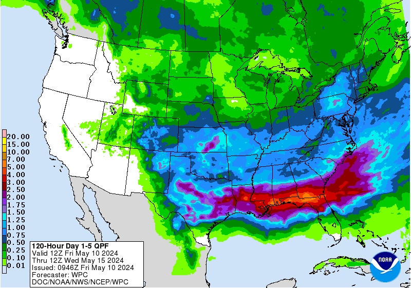
Forecast
Rainfall Accumulation between now and early Monday morning across the lower 48
courtesy of the Weather Prediction Center:
Notice
the bulls-eye of potentially very heavy rainfall over north Texas and
southeastern Oklahoma and Arkansas…that region could see upwards of 5-8+ inches
of rain over the coming days
No comments:
Post a Comment