Friday, September 18, 2015

When is it going to cool off? (Here’s a hint, not very soon)

Forecast Discussion:

Well folks, summer is quickly coming to an end, but temperatures sure aren’t getting the memo. Fall officially begins early next Wednesday morning (September 23rd) at 3:21 a.m. CDT. Looking ahead at the Climate Prediction Center’s 10-14 day outlook, they are wanting to keep things hotter and drier than normal across a good chunk of the lower 48, 
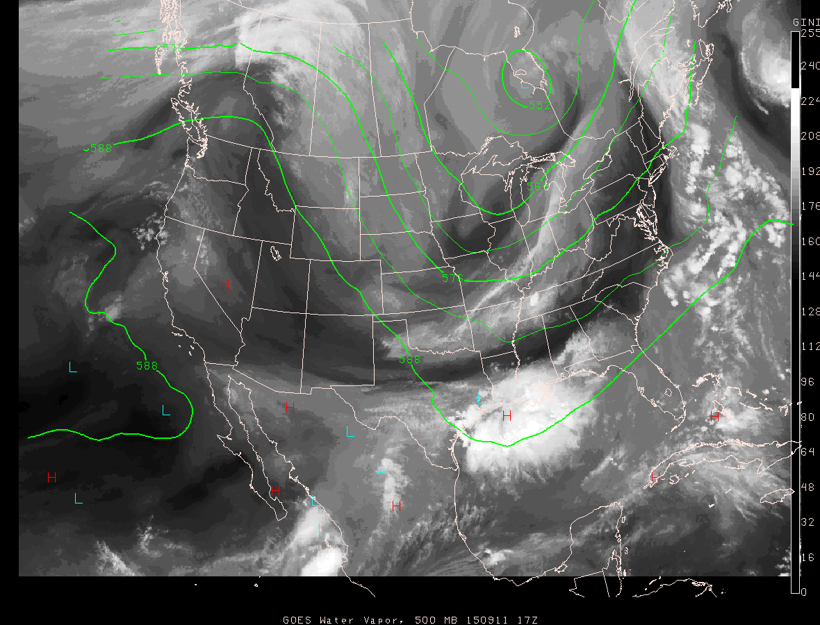
including Texas through the first of October. A large blocking ridge of high pressure continues to dominate our forecast here across the Lone Star State and long range models suggest that is likely to continue through next week. According to the latest model data, moisture levels here across the area should begin to drop off this weekend and into next week thanks to some drier heat air moving into the upper levels of the atmosphere over the area. Although, it will still be hot in the afternoon, less humidity will help things feel a bit better, especially during the evening, overnight, and morning hours. Hey, it’s not much, but at least it’s a start. I’m not seeing any significant cold fronts coming into the area for at least the next seven to ten days. Along with the lack of fronts, there is going to be a big lack of rain as well. Look for highs in the mid/upper 90s through the weekend into next week with overnight lows generally ranging from the upper 60s to the lower 70s. 

Climate Prediction Center 10-14 Day Outlooks:
Maps below valid now through the first of October and are always available at this link: http://www.cpc.ncep.noaa.gov/

Temperature Outlook:


Precipitation Outlook:


Current Drought Monitor:
All of south central Texas has fallen back into moderate to severe drought


El Niño Update:

As we head into October, the infamous El Niño, we have all been hearing so much about, will likely begin to have more of an impact here on Texas with increased chances for precipitation and hopefully some cooler than normal temperatures to go along with the chance of rain. Remember, El Niño seasons tend to bring wetter and cooler than normal conditions to Texas during the fall and winter months. 

Forecast Accumulated Precipitation now through the end of the month: Areas in white represent no rainfall accumulation. This is a look at what the GFS Model believes forecast rainfall to look like across the state. Notice the potential rains to our north and northwest.


Friday, September 11, 2015

September Cold Front

Forecast Discussion:

TGIF! We have some beautiful changes heading our way just in time for the weekend. With high pressure now located over the southwestern United States, a large trough of dip in the jet stream across the central and eastern lower 48 are allowing for the change in our weather pattern. Upper level winds now blowing out of the north northwest over Texas, which helped to pull disturbances and a weak frontal boundary through the area over the past couple of days that worked to generate the showers and storms across the area are pulling a second, stronger cool front through the state now. The leading edge of the drier, continental air mass is now working its way through Waco and should arrive in Austin late afternoon into the evening. As the front moves through a scattered shower or storm is not out of the question, some of which may produce brief heavy rains and lightning. The drier and slightly cooler air is lagging a bit behind the leading edge of the front, but it will be here! Sultry dew points in the 60s and 70s all summer have made things feel like a sauna around here to say the least, dew points will be dropping into the 40s and 50s this weekend and virtually all the sticky air will be swept back down into the Gulf. Look for a mostly sunny and beautiful late summer/early fall weekend with highs in the upper 80s to near 90 and lows in the 60s...low-lying, out-lying areas may even dip into the upper 50s early Saturday morning. Won't that be nice! Unfortunately, the cooler/drier weather will not be sticking around for long, as southeasterly surface winds will return to the area by Sunday into next week allowing for Gulf air and 90s to return.


500mb (~18,500 feet elevation) height level and mid/upper level water vapor imagery for the lower 48...this map is very useful in finding areas of high/low pressure also seeing the amount of mid/upper level water vapor present in our atmosphere...this map does not show clouds

The image below is available for your viewing at anytime by clicking HERE
(Image is courtesy of the department of atmospheric sciences at the University of Arizona)


Something to keep an eye on:

With a front located over the Gulf of Mexico this time of year, it is always wise to watch for any sort of tropical development. A cold front essentially provides lift in the atmosphere which works to spark showers and storms and also works to add, in very simple terms, a bit of spin to the atmosphere. Just something to think about and watch as we head into next week. The major forecast models we look at do not show anything to be concerned with at this time, however, we all know how fast things can change in the world of weather. 

Tuesday, September 8, 2015

Rain and a SLIGHT cool down on the way! Finally!

Forecast Discussion:

Hello everybody. I hope all of you are doing well. I've finally got some good news. It looks like rain and slightly cooler weather are finally on the way thanks to an early September cold front. Now don't expect to pull out the parka anytime soon, but some added cloud cover, rain, and a shift in wind direction should all contribute to some cooler and eventually drier air around here. We have been on a triple digit streak since the weekend, but that ended today as the mercury only (haha) soared to 99ºF...thanks Mother Nature.

Latest surface analysis as of 11:20 p.m. CDT showed a weak, stationary frontal boundary draped across Oklahoma extending west southwest through the TX Panhandle and into southern New Mexico. That front will continue to push slowly south over the next several days and as it does so, will work to boost our chances for showers and thunderstorms (doesn't that sound refreshing?)


Widespread showers and thunderstorms formed along that frontal boundary today across Oklahoma and the TX Panhandle and are still ongoing...heaviest activity is now located in southeastern Oklahoma as of 11 p.m. CDT Tuesday evening


Latest runs of the high resolution forecast models continue to indicate scattered showers and storms moving into south central Texas Wednesday afternoon...I think our best rain chances will come late Wednesday into Thursday as the actual frontal boundary (a.k.a. cold front) moves into the area. Quick weather lesson: a cold front in very simple terms is a boundary that separates two different air masses, in this case, drier continental air (or air originating over the continent) and sticky, tropical Gulf of Mexico air. As those two air masses meet, air along the boundary is forced to rise. It is in fact the dynamic lift produced by the cold front that allows, when given the correct conditions, for showers and storms to develop...I'm keeping my fingers crossed we are going to see some of that around here over the next several days.

If things go as planned over the next several days we could see up to an inch of rain in spots with most areas averaging between 0.25 to 0.50 inches of rain. At this point, we will take every drop we can get. Given the added clouds and chances for precipitation highs will come down slightly over the next several days into the lower to middle 90s vs. the upper 90s and 100s...by the time we get into the weekend slightly drier air will help it feel a little cooler around here (especially during the nighttime and early morning hours with lows dipping into the 60s and lower 70s, however, it will still be warm in the afternoon with highs in the lower to middle 90s.

Remember, it is still September after all, and we really don't see our first significant cool down until the end of September into October, but hey, I'm not complaining. At least we are heading in the right direction.

***Just a brief reminder, WHEN THUNDER ROARS, GO INDOORS***