Forecast Discussion:
The large area of light rain showers with embedded areas of moderate to at times heavier downpours will continue to shift east and northeast away from the I-35 corridor for the remainder of the day. This activity was able to develop thanks to a disturbance embedded within the strong southwesterly wind flow aloft over the area in advance of a potent and deep upper level trough, or valley, of lower atmospheric pressure to our west. The main upper level low associated with this approaching storm system is currently spinning over the desert southwest (Arizona and New Mexico).
You can clearly see that counter-clockwise rotation along the Arizona/New Mexico Border in the latest visible satellite image loop...that's the upper level low! The long tail of clouds out ahead of the circulation that extends across far west Texas and Mexico is the Pacific Front, pretty cool, huh?

Current 500 millibar Wind Flow (winds around 18,500 feet above the surface, check out that giant dip across the western United States...that's the trough! Image below courtesy of Windyty.com >>> check it out HERE

Current Position of the Pacific Front:
>Breezy southerly winds here at the surface, and especially just above the surface will continue to advect, or more simply, transport, moist Gulf air into the area ahead of the approaching upper level trough and its associated surface frontal system. The Pacific Cold Front is currently moving through far west Texas. In their latest weather observation report, the El Paso International Airport is reporting a wind shift/frontal passage. Winds in El Paso are now gusting out of the west northwest over 25-40 mph with light rain falling and current temperatures in the mid 40s.
Tonight's Storm Threat:
>A line of strong, potentially severe thunderstorms is forecast to move through south central Texas late tonight into early Sunday morning as the upper level trough and Pacific Cold Front force the sticky, Gulf air mass to rise and precipitate. Meteorologists refer to lines of storms as "Squall Lines" and/or QLCS (Quasi-Linear Convective Systems). Squall lines are common in the spring, fall, and winter months in accordance with the presence of cold fronts.
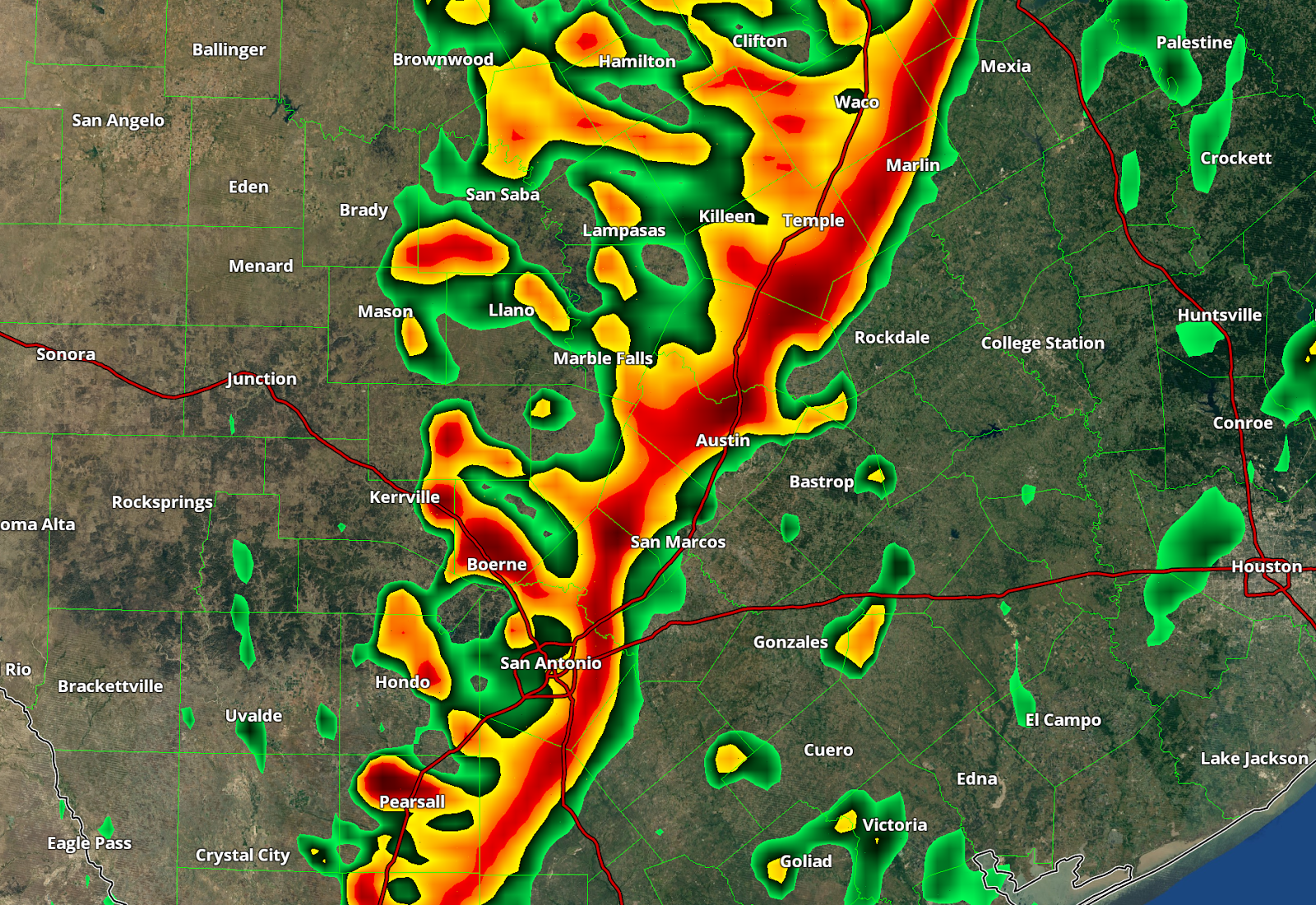
Squall Line Forecast Position 3 A.M. Sunday Morning according to the NAM 4 km Model...this line of storms will stretch from Oklahoma City all the way down I-35 through Dallas, through Austin, through San Antonio to the Mexican Border
***The images below are a forecast model's simulation of what it thinks radar will look like at 3 am...use the images below to get a better idea of what radar MAY look like early Sunday morning...I can tell you, that this is not the only model forecasting this*** Remember, computer forecast models are just another tool in forecasting.

Zoom In on Central Texas from the Image Above
The biggest threat with tonight's storms will be strong, gusty winds of 40-60 mph. The hail threat and the tornado threat are both low. In addition to the potential strong wind gusts, heavy rainfall and deadly cloud to ground lightning will accompany all thunderstorms. Due to the threat for potentially damaging thunderstorm wind gusts across the area tonight, the Storm Prediction Center out of Norman, Oklahoma has placed all of central Texas in the SLIGHT RISK CATEGORY (yellow-shaded area) for severe weather tonight.

The risk of flash flooding is LOW, due to the fast-moving, progressive nature of this storm system. We can expect to receive between 0.50 to 1.50 inches of rain out of this forecast rainfall event.
Sunday's Forecast:
Showers and thunderstorms will be well east of the area by mid to late Sunday morning as significantly drier and slightly cooler air moves into the area on the backside of this approaching upper level Pacific storm system. We will see plenty of sun and blue sky for your Sunday afternoon with temperatures mainly in the 60s. With a clear sky and dry air in place Sunday night, temperatures will drop into the 30s and 40s across the area, however, we will stay safely above freezing.
No comments:
Post a Comment