Dew Point Temperatures Friday Morning:

Increasing moisture levels at both the surface and aloft combined with several disturbances that will be passing over central Texas this weekend from the southwest will make showers and thunderstorms likely. As a cold front approaches the area next Tuesday, the threat for heavy rain will increase.
Day by Day Forecast:
Friday: Cloudy, mild, and muggy AM in the 70s will give way to a partly sunny, warm, and muggy afternoon with highs in the mid to upper 80s area wide. There is a 30% chance for showers during the afternoon and evening.
Saturday: 50% chance for showers and scattered thunderstorms; some of the rain may be heavy at times (especially during the afternoon hours thanks to daytime heating which helps to destabilize the atmosphere). Highs will be in the 80s with lows in the 70s.
Sunday: 60% chance for showers and thunderstorms; some of the storms will produce heavy downpours. Highs will be in the 80s with lows in the 70s.
How much rain are we talking?
The Weather Prediction Center (WPC) is forecasting a good 1-2 inches of rain to fall between Friday and the middle of next week across central Texas.

The latest GFS Forecast Model is suggesting just over 2 inches of rain for the Austin Area between Friday and the middle of next week.
COLD FRONT
A fairly strong cold front looks to move through the area next Tuesday. Behind the front skies will rapidly clear and drier and cooler air will invade central Texas on breezy northerly winds. Highs will be knocked down into the 70s and lower 80s with lows in the 40s and 50s for the middle/end of next week under mainly sunny/clear skies. Ahead of the front on Tuesday, heavy rain looks to be likely.
Front moving in Tuesday Afternoon:
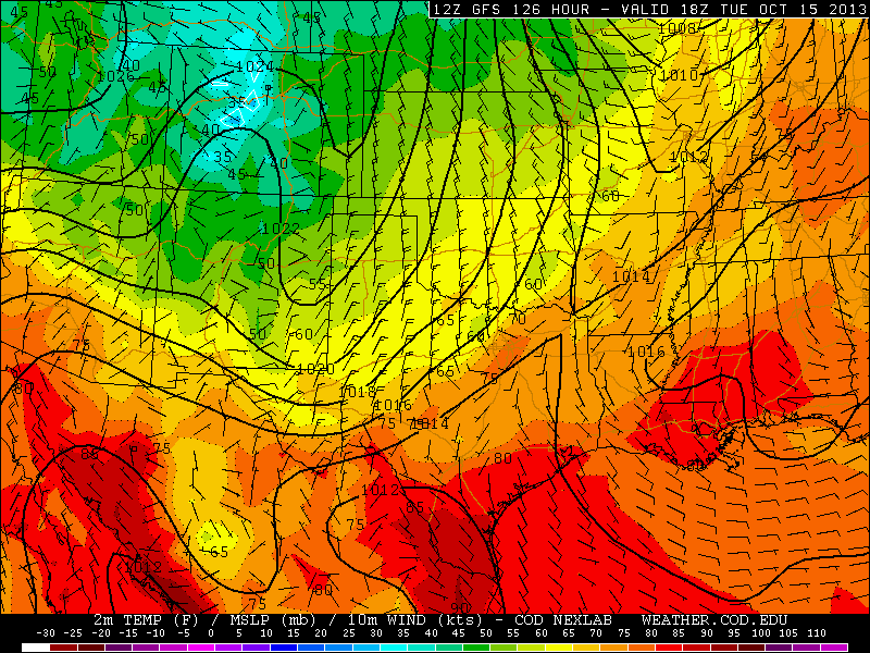
The GFS Model has a good chunk of the state of Texas in the 40s by early Thursday morning of next week!

No comments:
Post a Comment