Saturday, March 30, 2013

Relief on the way! Severe Storms Possible too!

Good afternoon everybody. I hope you are all having a wonderful Easter weekend. As of 4 p.m. the mercury has climbed to 84ºF here in Austin under a partly to mostly cloudy sky. Tonight, mostly cloudy, breezy, mild and humid with lows in the 60s. A large cluster of thunderstorms is forecast to develop across Oklahoma late tonight and push south into north Texas through the overnight hours. As that disturbance approaches central Texas during the day tomorrow, showers and storms are likely to erupt across the area. The Storm Prediction Center has placed all of central Texas under the SLIGHT RISK category for severe weather tomorrow (Easter). There is a 50% chance for showers and storms, some of which may become strong or severe with damaging winds and large hail being the primary threats. Highs will climb from the 60s Easter morning into the 70s and 80s by afternoon under a mostly cloudy sky. Storms will be sporadic and fast-moving in nature, therefore, beneficial rainfall is not likely, however, a few locations may receive a healthy dousing.

Forecast radar at 8 a.m. Easter Morning (large cluster of storms pushing into north Texas out of Oklahoma):


Forecast radar at 2 p.m. Easter afternoon shows some strong/severe storms possible in central Texas: 


YELLOW = RISK OF SEVERE THUNDERSTORMS


Much better chances for widespread, beneficial rainfall comes Tuesday and Wednesday of next week. Highs will climb well into the 80s Monday afternoon ahead of a strong cold front that will push through the area during the morning hours of Tuesday with a cluster of showers and thunderstorms. Rain will continue behind front for Tuesday night and Wednesday. The GFS model is forecasting widespread rainfall amounts over an inch between now and Thursday across all of central Texas. Keep your fingers crossed. Still expecting a significant cool down behind the front for late Tuesday into Wednesday.

GFS Forecasted Rainfall Accumulation:


NAM Model is forecasting much less in the way of rainfall for central Texas with north Texas receiving the heaviest amounts.

COOL SHOT OF LIGHTNING OVER LAKE TRAVIS FROM THE STORMS THAT MOVED THROUGH BACK ON MARCH 20th


Friday, March 29, 2013

Storm Chances, Easter, and a BIG Cold Front!

Hello everybody! Let's jump right into it. Moist, southerly flow has definitely returned to the area as evidenced by the BIG increase in humidity, cloud cover, and warmer temperatures. Just think, we had a near area wide freeze Monday night/Tuesday morning. 

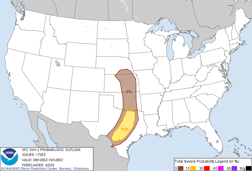
The Storm Prediction Center has placed eastern portions of the Texas Panhandle, portions of northwest Texas, and western Oklahoma under the SLIGHT RISK category for severe weather this afternoon. Disturbances moving from west to east at about 18,000 feet will interact with warm surface temps, plentiful amounts of moisture, and the infamous dry line to produce a decent shot for strong/severe storms late this afternoon/evening across those areas. The storms would be capable of producing large hail, damaging winds, and possibly an isolated tornado. Latest high resolution forecast models keep those storms away from central Texas tonight, however, they show that there is the possibility for those storms that develop across the Panhandle and western Oklahoma to organize into a squall line (line of storms) and possibly blow through the DFW Metroplex early Saturday morning (before sunrise) if they are able to maintain their strength. 

SLIGHT RISK = YELLOW/GENERAL THUNDERSTORMS = GREEN


FORECAST RADAR AT 10 P.M. THIS EVENING


FORECAST RADAR AT 3 A.M. SATURDAY MORNING


As for us here in central Texas, it is going to be a long stretch of mostly cloudy, warm, and humid days. Highs will climb into the 80s Saturday-Monday ahead of a strong cold front that will blast through the area late Monday/early Tuesday...there is a 20-40% chance for showers and storms Saturday-Monday across central Texas...strongest storms would be experienced across the western Hill Country (storms that develop across west Texas along the dry line will have the potential to push as far east as the Hill Country)...it is not completely out of the question that if an organized line of showers and storms forms out west, it may make it as far east as the I-35 corridor. Slightly better chance for storms late Monday as that strong front I mentioned sweeps through the area with gusty northerly winds sustained near 20 mph developing behind the front as highs drop some 25-30ºF across the area from Monday afternoon to Tuesday afternoon. Temps will climb well into the 80s Monday with highs only expected to make the 50s to possibly 60 Tuesday afternoon under a cloudy and showery sky. This front will not give us a freeze as widespread heavy cloud cover will keep ALL of central Texas safely above freezing.

BIG FRONT: (How's this for a temperature difference???) Source of the cold air is far northern Canada!

Laredo will be close to 100ºF on Monday while Amarillo will be below freezing! Waco will be at 85ºF while Dallas will be in the 40s by late Monday afternoon! Incredible front! Looks like winter is playing some tricks on spring this year)

3 p.m. Monday:


6 p.m. Monday:


Easter Forecast:

Cloudy, drizzly AM in the 60s will give way to a partly sunny & WARM afternoon with highs in the 80s; there is a 20% chance for a shower or thunderstorm.

Keep your fingers crossed that we receive some rainfall because the latest soil moisture models are quite depressing. Much of the state of Texas has less than 10% moisture in the soil...that's DRY! As of the latest drought monitor released yesterday, 98% of the state of Texas is in drought...central Texas is in the severe to extreme drought categories.

Soil Moisture Percentages:

Texas:

United States:

Drought Monitor:


***IF YOU ARE ON FACEBOOK, PLEASE LIKE MY WEATHER PAGE, MICHAEL'S WEATHER CENTER, FOR MORE FREQUENT WEATHER UPDATES***


Friday, March 22, 2013

THE CAP

The infamous cap; where shall I begin. Over the coming months you will most likely see me writing a lot about the cap. The cap is a critical forecasting element for severe weather season here in central Texas which runs from March 1st through mid June. So, I'm sure you're asking yourself, what is the cap? In this blog I hope to help you all better understand the cap and its effects on the weather here in central Texas.

Weather Scenario: 

It is mid May here in Austin and it is HOT and HUMID...the temperature is at 90ºF and the dew point [measure of the amount of moisture in the air] is high at 72ºF. Gusty southeasterly surface winds continue to pump in plentiful amounts of sticky, moist Gulf of Mexico Air feeding into a strong area of surface low pressure over southwestern Oklahoma and northwestern Texas; extending southwestward across west Texas is a strong frontal boundary separating the hot and humid air over central, north and south Texas from the cool, dry air across west Texas. Basically what I am getting at is that it is the perfect set up for severe thunderstorms to form.

There are three key ingredients needed for thunderstorm development. The first ingredient is moisture, the second is instability (warm rapidly rising air into cooler air aloft), and lift (trigger for air at the surface to rise...several factors cause air to rise, the most common of these triggers is convection). Remember, warm air rises because it is less dense than cool air, therefore, hot air at the surface will rise...as that air rises it is forced to expand and cool, when the air reaches the saturation level [level where the air temperature is equal to the dew point temperature] the relative humidity jumps to 100% [meaning the air is saturated] it cannot hold any more moisture. When that rising air passes the saturation level, air is condensed and forms clouds. As that air continues to rise into even colder air aloft, eventually passing the freezing line, the growing cumulus cloud is able to strengthen into a thunderstorm.

So, where does the cap fit into all of this? Remember my description of the perfect severe weather setup in the second paragraph? Watching the latest visible satellite imagery, I see towering cumulus clouds trying to develop across west Texas along the frontal boundary, however, as fast as they rise they drop. Something is inhibiting those towering cumulus clouds from building into thunderstorms. That "something" is the cap [a.k.a. lid on the atmosphere]. 

What is the Cap? Where does it come from?

GEOGRAPHY OF MEXICO (SHADED RELIEF MAP):
 

In order to understand the Cap, we need to understand the geography of our neighbor to the south, Mexico, first. There are two major mountain ranges in Mexico running from northwest to southeast; The Sierra Madre Oriental occupies the eastern side of Mexico and the Sierra Madre Occidental occupies the western side of Mexico...in between these two mountain ranges is a high and dry plateau that consists mainly of deserts. That desert air is generally trapped in between the two mountain ranges for much of the year, however, when strong mid-latitude cyclones (low pressure systems) blow across the United States during the winter and spring air is forced to move north into the low pressure system from areas of higher pressure around it. Remember, high pressure flows into low pressure. Therefore, that desert air is forced to move out of Mexico to the north...keep in mind, the plateau is at least 4,000 feet in elevation while Austin sits at 750 feet above sea level, therefore, that warm and dry desert air moves south to north at or above 5,000 feet aloft...that layer of desert air that is forced northward is known as the cap (or the lid) on our atmosphere.

Here are some graphics to help better explain this weather phenomenon: 

Wind Direction:


CAP SETUP: HOT, DRY AIR ALOFT INHIBITS THUNDERSTORM FORMATION:


DAY WHEN THE CAP IS PRESENT AND STRONG:


REAL IMAGERY EXAMPLE:


 DAY WHEN THE CAP IS NOT PRESENT OR VERY WEAK:


It may be helpful to think of the cap and its influence on the weather here in central Texas as a boiling pot of water on the stove. If you put a lid on a boiling pot of water, all of the heat energy (lift) being produced from the boiling water will be trapped under the lid and continue to build up; eventually the increasing pressure and built up energy under the lid will eventually cause the lid to blow off of the pot of boiling water in a violent fashion. If warm, rising air is able to break through the cap, very severe storms are likely to develop which would have the potential to produce extremely large hail, destructive winds, and violent tornadoes. If there was no lid on the pot, the energy produced from the boiling water would be able to freely distribute itself and escape. That warm, rising air into cooler air aloft (above) allows for thunderstorms to develop much more sufficiently.

Unfortunately, the cap does block a lot of our rain chances here in central Texas during the spring months, however, it also saves us from seeing a great deal of severe weather during certain instances. Remember, if the rising air is able to break through the cap, watch out, severe weather is likely.

Here's another great graphic explaining the cap from WFAA-TV Meteorologist Steve McCauley in Dallas:


Updrafts and Downdrafts:


Friday, March 8, 2013

Severe Weather Possible This Weekend

Well we officially received 0.16 inches of rainfall at Camp Mabry and 0.05 inches of rainfall at the airport today. Currently seeing a lull in the activity and that should continue through the evening as a pocket of drier air passes over central Texas from the west. Warm, moist southerly flow over the cooler air here at the surface allowed for the light rain and drizzle across portions of the area earlier today; we call that overrunning. 

Taking a look at latest water vapor satellite imagery, our next low pressure system that will be bringing us a good chance for widespread shower and thunderstorm activity is clearly visible spinning counter-clockwise over Arizona.


Here's a look at the latest visible satellite imagery as of 4:35 p.m. CST. Thunderstorms are starting to fire across portions of the Texas Panhandle. Do you see that clear spot out west of San Angelo in between Midland? That's the pocket of drier air I was mentioning that should give us a lull in the rainfall chances for this evening.


As that upper level low pressure system coupled with a surface low and a strong cold front push across the area late Saturday into the early-morning hours of Sunday, I am expecting a line of showers and thunderstorms to develop. Some of those storms that develop tomorrow evening/night will become strong or severe with damaging winds and large hail; an isolated tornado cannot be completely ruled out. The Storm Prediction Center (SPC) out of Norman, Oklahoma has placed all of central and north Texas (including the major metro areas along the Interstate 35 corridor) under the SLIGHT RISK CATEGORY for severe weather...areas shaded in yellow have the best shot at seeing severe weather.


CAPE Values will be on the moderate to high side across the area, therefore, the slight risk of severe weather must be included in the forecast. The higher the CAPE values the better the chance for severe weather. CAPE basically looks at how fast the air is rising; quickly rising air will form stronger storms.


Saturday's Forecast:

Warm and moist southerly winds will pick up through the day as the storm system out west pushes closer to central Texas. Those breezy southerly winds will allow for temperatures to climb well into the 70s. South Texas will climb well into the 80s and lower 90s! Laredo's forecast high temperature for Saturday is 92°F. Skies will start cloudy on Saturday with mild temperatures in the upper 50s and lower 60s. Skies will turn partly sunny by afternoon with a 30% chance for scattered showers.

Latest high resolution forecast models are indicating that between 9 p.m. Saturday and 12:00 a.m. Sunday, storms will begin developing across the Hill Country and push their way across the Interstate 35 corridor after midnight. Behind the line of storms light to moderate rain will persist into the early morning hours of Sunday. 

Forecast Radar Image at Midnight Sunday Morning: (Showers and Storms Developing out west)


Forecast Radar at 3 a.m. Sunday Morning (Showers and storms overhead):


Forecast Radar at noon Sunday (Rain pushing east of central TX):


Skies will slowly clear through the day on Sunday as much drier and cooler air filters into the region on strong northerly breezes. Lows will fall into the 30s and 40s Sunday night with highs only managing the 60s on Monday under a sun-filled blue sky. Temps drop into the 30s area wide Monday night; some low-lying and out-lying areas may receive a light freeze.

So, how much rain are we talking? The latest NAM model is not very impressive with much of the area receiving 1/4 inch or less of rainfall. The GFS Model is much more optimistic, forecasting a widespread 1/2 to 1 inch of rainfall across the area (I personally believe most will end up with at least a half an inch of rain).

GFS Forecasted Rainfall Accumulation: (Check out the KEY to see how much rainfall your area is forecasted to see)


Tuesday, March 5, 2013

Rain???

Rain chances look to return to central Texas for this coming weekend and may begin as early as Friday night, peaking on Sunday and then decreasing for the start of next week. 

I'm already watching a strengthening low pressure system just off of the coast of the coast of the Pacific Northwest this morning. This is the system that would move across the southern plains and Texas and bring us our rain chances.


Rain Chances:

Friday Night: 20% chance for light showers

Saturday: 20% (Rain chances increasing across the Hill Country late in the day)

Sunday: 50% chance for a line of showers/thunderstorms to blow through

Latest Rainfall Projection for central Texas between now and next Sunday evening look to be anywhere from 0.25 to 0.50 inches. We can use every drop. According to our latest drought monitor all of central Texas is experiencing moderate to severe drought conditions.


ECMWF Model showing storm system approaching us:


GFS Model showing storm system approaching us:


GFS Model shows a line of showers and storms developing across west Texas late Saturday and moving through central Texas during the early-morning hours Sunday: 


The greatest risk for possible severe storms (large hail, damaging winds) will be across west Texas on Saturday:


Line of storms would not be able to develop much farther south than San Antonio due to a strong capping inversion over south Texas on Sunday...southwesterly winds at 5,000 feet aloft blowing into the approaching low pressure system pulls dry, warm air off of the Mexican Plateau and pushes it over Texas. This acts as a lid on the atmosphere because you need warm air rising into cool air aloft for rain to develop. In the case of the cap, warm air rises into cool air, however, it hits a layer of warm, dry air (the cap) which inhibits rain development.

Forecasted Cap: (Blues, pink, and gray indicate strong cap, or lid)


It will be interesting to see how strong the cap will be over the area by the weekend. If there is enough lift in the atmosphere (rising air) associated with the low pressure system and enough forcing at the surface along a pacific frontal boundary, the cap will be able to weaken and allow for showers and thunderstorms to blossom. 

Sunday, March 3, 2013

Warm Monday!

Good evening everybody. Hope you are all enjoying this beautiful Sunday. We officially climbed to 77°F this afternoon at Camp Mabry thanks to a gusty southerly wind and a warm, westerly wind aloft. Temps will fall into the 40s and 50s area wide tonight with a southerly breeze continuing. 

Monday's Forecast: Cool start will give way to a mostly sunny & WARM afternoon with highs expected to top out in the 80s across the area; 90s are likely across the Texas-Mexico Border. We can thank strong southwesterly winds aloft and at the surface for the big warm-up. Very windy cold front will blow through the region late Monday into the early morning hours of Tuesday will drop highs back down into the 60s on Tuesday. RED FLAG WARNINGS have already bee issued for all of Central Texas for Tuesday as dry air, gusty northerly winds of 20-35 mph and dry vegetation will allow for critical fire weather conditions to develop. We drop into the 30s Tuesday and Wednesday nights. 


Rain chances look to be on the increase for the weekend, especially for Sunday. Keep your fingers crossed.