Thursday, June 12, 2014

Severe Threat Today

Good Afternoon everybody. I hope you are all doing well. I just wanted to send out a quick weather update to inform you all on what has the potential to be a rather stormy late afternoon/evening around central Texas. Several factors are coming together to make the atmosphere prime for severe weather later this afternoon and into the evening hours. The Storm Prediction Center out of Norman, Oklahoma has placed a large portion of Texas, including central Texas, under the SLIGHT RISK CATEOGRY for severe weather today. Much of Central Texas, including the Austin Metro Area, has been placed under an enhanced risk for severe weather this afternoon. Storms that develop will have the potential to turn rapidly severe with extremely large hail, ranging from the size of dimes to as large as baseballs, damaging winds in excess of 60 mph, torrential downpours, and thousands upon thousands of strikes of deadly cloud to ground lightning. The Storm Prediction has even mentioned that a tornado or two is not out of the question this afternoon. 

RISK AREA (ENHANCED RISK SHADED IN RED):


I’m putting the chance for thunderstorms this afternoon/evening at 50%. That means that anywhere in central Texas has a 50% chance of seeing a thunderstorm today. Of course, it is hard to pinpoint exactly where these storms will develop, however, the most likely point for storm initiation will be the far western and northwestern Hill Country (these storms that develop will have the best potential for producing hail up the size of baseballs and possibly a tornado or two), however, that is not to say that large hail and an isolated tornado is out of the question for the I-35 corridor.

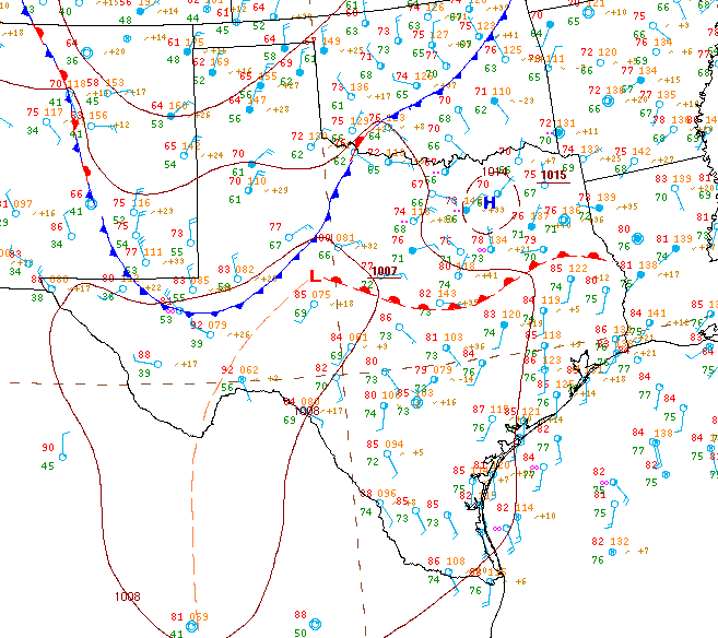
TODAY'S WEATHER SET-UP:

See Image Below:
A weak cold front (currently located in northwest Texas, that’s the blue line with the blue triangles). That cold front is located near an area of surface low pressure which is dragging plenty of rich, gulf moisture into central Texas as evidenced by dew points in the 70s! That is south Florida air! Just ahead of the cold front is the dry line which separates moist Gulf Air to the east of it from dry desert air to the west. As these features approach the area from the west this afternoon, combined with a quick moving disturbance in the upper levels of the atmosphere, severe storms are likely to develop. While there is a fairly strong cap in place, a layer of warm, dry air around 5-8,000 feet above the surface, sufficient daytime heating and lift should allow for storms to erupt given the strong cap in place. The intensity of the storms is all going to depend on how much sun we see and how hot we are able to get. Areas to our southwest along the Texas-Mexico border will be well into the 100s this afternoon with temperatures approaching 110°F in a few locations.

LATEST SURFACE ANALYSIS:


The area of high pressure that was parked over us much of last week and the past couple of days has retreated back to our southwest into northern Mexico. The clockwise flow around high pressure develops a west and northwesterly wind above Texas around 18,000 feet into the atmosphere. Those steering winds will pull storms that develop to our north and west into our area. Think about the winds as a river of air, embedded within that river are ripples (a.k.a disturbances) that produce lift in our atmosphere.

NORTHWEST FLOW GRAPHIC:


FORECAST RADAR:


Wednesday, June 4, 2014

Early June Outlook

Hello everybody! Meteorological summer officially started on Sunday (June 1st). With a ridge of high pressure firmly in control of our weather after last week’s wonderful rains things have been quite boring around here with the typical morning clouds giving way to partly sunny, warm, and humid afternoons. Honestly, that pattern looks to continue through the weekend. Slight rain chances look to enter the forecast by Sunday Night and persist through the first half of the day on Tuesday of next week. The ridge of high pressure that is currently dominating our weather will briefly break down by late this weekend and shift to our southwest. That puts a northwesterly flow across Texas in the upper levels of the atmosphere (around 18,000 feet), meaning winds will be blowing from northwest to southeast across the state.

This northwesterly flow is important because storm complexes that develop across far northwestern portions of the state are forced to move towards the southeast into both north and south central Texas. This is a very common early summer set-up. If those storm complexes that develop several hundred miles to our north are able to survive the trip south, they have the potential to bring us some good rainfall as well as a slight risk of severe weather, mainly in the form of strong damaging winds and lightning. Until then, expect more of the same with cloudy, warm and humid nights in the upper 60s and lower 70s giving way to partly cloudy, warm, and humid afternoons with highs in the upper 90s. Thanks to last week’s drenching downpours the soil is still quite moist which has helped to keep afternoon highs quite a bit lower than they could be for early June. However, as that soil moisture begins to dry up temperatures will begin to soar. These northwest flow thunderstorm events are hard to predict this far out, stay up to date with all of the latest weather developments on my Facebook Page: Michael's Weather Center and my Twitter account: WeatherMinute (Just click the names of my pages to access them).

Northwest Flow Graphic:


Last week’s rains have helped the drought across the area somewhat, especially for areas along and east of Interstate 35 where drought conditions have dropped into the abnormally dry and moderate drought categories. A large portion of the Hill Country is still stuck in Extreme Drought Conditions and areas southwest of the Hill Country towards Del Rio are stuck in the Exceptional Drought Category (the worst type of drought).

Latest Drought Monitor:


Both lakes Buchanan and Travis are 39% full and currently hold about 788,463 acre-feet of water, according to the LCRA. The surface of Lake Travis is currently sitting at 629.23 feet above sea level and the monthly average for Lake Travis this time of year is closer to 670.01 feet above sea level. Lake Travis is over 40 feet below average!! Unfortunately, the Climate Prediction Center is forecasting drought conditions to persist and intensify across a good chunk of Texas and Oklahoma as well as southern Kansas between now and the end of August. The three month temperature outlook is forecasting above normal temperatures through the summer with equal to below normal chances for rain.

Drought Outlook:


3-Month Temperature Outlook:


Given a possible developing El Niño, NOAA (The National Oceanic and Atmospheric Administration), is forecasting a near normal or below average hurricane season. They are predicting three to six hurricanes to form in the North Atlantic this season. Keep in mind, the season could be an active one even though the forecasts are forecasting differently. Accuweather is forecasting areas from the central and eastern Gulf of Mexico up through the East Coast will be most vulnerable for impacts from a tropical storm. It is going to take a persistently wet fall and winter or a major rainmaker from the Tropics to help us with our drought situation.