Sunday, December 31, 2017

Arctic Cold

Forecast Discussion

Frigid, Arctic Air continues to ooze south into the lower 48 and the far southern extent of this enormous Arctic Air Mass is just beginning to move into central Texas. We have already reached our high for today in Austin of 43ºF (at midnight) and have already fallen to 38ºF as of the noon update. Many locations across the western and northwestern Hill Country have already dropped into the upper 20s and lower 30s. Waco and Dallas have already dropped below the freezing mark (32ºF). 

12 p.m. CST Air Temperatures across the Nation [Sunday, December 31, 2017]


Potential Freezing Drizzle New Year's Eve

Thick cloud cover with embedded areas of mist/drizzle will be possible through the day today and into the evening hours tonight. As temperatures drop below the freezing mark (which should happen around 6-7 p.m. this evening in Austin), we will have to keep an eye out for any freezing drizzle that may develop and potentially cause some issues on area roadways later this evening as folks are out and about ringing in the new year. Elevated roadways (bridges and overpasses) will need to be monitored closely should and if any freezing mist and/or drizzle decides to fall. The folks at the National Weather Service believe the majority of the freezing drizzle concern should stay well west of the I-35 corridor, see their graphic below (areas in blue not expected to receive light freezing drizzle):


Arctic Cold Freezing Tips

Temperatures will drop below freezing across the area this evening and potentially could stay below freezing until Tuesday afternoon for many areas (especially north and west of Austin). This prolonged period of subfreezing temperatures can wreak havoc on your plants and pipes if you do not take appropriate action to protect them. It's a good idea to wrap any/all exposed pipes and water faucets/hydrants on your property and when temperatures drop below freezing it may be a good idea to play it safe and drip one or two faucets in your house and leave cabinet doors under your sink open for warm air to circulate (especially for those sinks/pipes that are located next to/along an exterior wall). In addition to plants/pipes remember to protect yourself from the cold by dressing appropriately in layers and making sure to protect your head and chest, and please don't forget about your pets. 

Slight Chance Freezing Rain/Sleet on New Year's Day

A disturbance moving across the area on New Year's Day may generate some areas of light freezing rain and sleet (especially for areas south and west of Austin). We will need to monitor this closely as this may cause a concern for elevated roadways.


Day by Day Forecast (valid for Austin, TX):


Tonight: 25º | Cloudy, cold, and breezy; patchy light drizzle/and/or freezing drizzle possible early; wind chills in the teens...use caution on roads

New Year's Day: 32º | Mostly cloudy and cold with a slight chance for sleet (ice pellets)...wind chills in the 20s

New Year's Day Night: 22º | Partly cloudy and very cold; 10s in out-lying/low-lying areas 

Tuesday: 35º | Partly sunny and cold

Tuesday Night: 20º | Mainly clear and very cold; 10s in out-lying/low-lying areas

Wednesday: 45º | Mostly sunny and warmer

Hazardous Weather Outlook from the Austin/San Antonio National Weather Service:


The coldest air of the season will move into the region with
temperatures falling below freezing across the entire area New
Year`s Day morning. Temperatures across the Hill Country will stay
below freezing until sometime Wednesday. Low temperatures Tuesday
and Wednesday will in the middle teens in the Hill Country and
lower to middle 20s elsewhere.

Locations across the Hill Country could experience freezing
temperatures for more than 60 consecutive hours beginning New
Year`s Eve. Some locations along the I-35 corridor from Austin to
San Antonio could experience freezing temperatures for 24 to 36
consecutive hours beginning early New Year`s morning.


Wednesday, December 27, 2017

New Year's Eve Arctic Blast

Forecast Discussion

Hello folks. I hope all of you had a wonderful Christmas holiday. Cold, Arctic Air has settled in across a large portion of the country. Modified Arctic Air has made it into central Texas and has helped to drop temperatures into the 30s and 40s across the area. Highs Wednesday only made it to 41ºF at Camp Mabry and Austin Bergstrom International Airport. As of Wednesday evening, temperatures have dropped into the 30s area wide with wind chills in the upper 20s to lower 30s. 

7 p.m. Wednesday Evening Nationwide Temperatures 


SLOW Warm-Up Ahead of New Year's Eve Arctic Cold Front

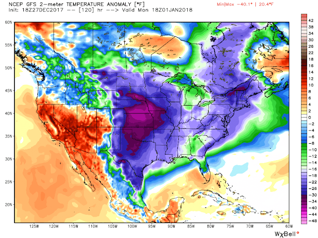
Temperatures over the next several days will slowly continue to rise ahead of an Arctic Cold Front that is forecast to arrive in Central Texas on New Year's Eve. Highs on Thursday will slowly "warm" back into the middle to perhaps upper 40s across the area under a mainly overcast sky, lower to middle 50s by Friday, and lower 60s by Saturday as southerly winds return to the area. The Arctic Cold Front looks to arrive late Sunday morning into early Sunday afternoon with rapidly falling temperatures and a gusty north winds. It looks like temperatures will be at or slightly below the freezing mark when the clock strikes midnight New Year's Day with wind chills in the teens and 20s across the area. Some forecast models are hinting there will be an opportunity for some freezing drizzle/rain and/or a few snow flurries New Year's Eve. We will need to watch this closely. We all know that it only takes a small amount of ice to wreak havoc on area roadways (especially elevated bridges and overpasses). Latest forecast model guidance is indicating that the majority of the precipitation should dry up just before temperatures drop below freezing in Austin, but it will need to be monitored closely. Especially if your travel plans take you north and west of Austin.

Forecast Upper Level Winds Favor an Arctic Air Mass to move south

Forecast Temperature Anomaly (indicating well below normal temperatures across a large portion of the country early next week)


Arctic Cold to ring in 2018

A frigid Arctic air mass will remain entrenched across the area through at least the middle of the first week of 2018 keeping highs in the 30s Monday (New Year's Day) and Tuesday, most likely not much above freezing, with hard freezes likely during the overnight hours as temperatures are likely to drop into the lower to middle 20s across the region. You will need to make sure and wrap your exposed pipes as we have the potential to remain below freezing for long amounts of time. 

Thursday, December 21, 2017

First Day of Winter

Forecast Discussion

Near Record Warmth Today
Despite the fact that winter officially arrived at 10:28 a.m. CST this morning, afternoon high temperatures on this first day of winter topped out just below record highs. Camp Mabry’s high coming in at an astoundingly balmy 79°F (record high 81°F set back in 1970) and the airport topped out at 78°F (record high 81°F set back in 1970). The average or “normal” high for this time of year should be closer to 62°F. Breezy south southwesterly winds at the surface, sunshine, and southwesterly winds above the surface allowed for the spike in temperatures today.

Cold Front Arrives Tomorrow (Friday) with Rain and Sharply Colder Temperatures
The first of two Canadian cold fronts is set to arrive in Austin Friday morning between 9-noon. As of 6:00 p.m. CST Thursday evening, the leading edge of the cold front is just approaching Lubbock and the temperature in Amarillo has already dropped to 32°F. As the upper level storm system associated with this surface frontal system approaches the area late tonight, areas of showers and isolated thunderstorms have the potential to develop and possibly become more widespread as the cold front gets closer to the area during the early to mid-morning hours. Those locations that receive rain will likely receive somewhere between 0.10 to as much as 0.50 inches of rain. This rainfall event does not look to be as heavy as the rains we experienced across the area late Monday and Tuesday of this week.

6 P.M. CST Thursday Evening Temperature Map


With that being mentioned, the Storm Prediction Center has placed the area in a very low end risk category for severe weather on Friday (especially for areas east and southeast of the I-35 corridor saying this, “A marginal threat for a severe storm or two may exist across central/eastern Texas, primarily during the day.” Area shaded in dark green on map below under the marginal risk for severe weather on Friday (very slim chance). 


If the cold front moves through earlier in the day, the threat of severe weather/strong storms will be near zero…if the cold front decides to slow down a bit and let the air mass ahead of it heat up and destabilize, then there is a SLIGHTLY better chance for an isolated strong/severe storm. I’m thinking the front moves through early enough to only generate some general rain shower activity with some pockets of moderate to heavy rainfall from time to time. Some of the models keep things fairly dry, others continue to indicate rain is going to fall.

Despite the rain and the storms, a noticeable drop in temperatures will be felt behind the front with temperatures dropping from the 60s and 70s ahead of the front into the 40s and 50s (some spots across the northern and western Hill Country may spend quite a bit of the day in the 30s) behind it. You’ll definitely want to leave the house in the morning with a rain jacket/winter coat. Everybody drops into the upper 30s and lower 40s Friday night/Saturday morning. No wintry precipitation is expected!

Christmas Weekend and Christmas Day
Skies will clear out for the most part on Saturday as high pressure builds into the area from the west behind Friday’s cold front/storm system. Sunshine will help highs climb into the 50s to near 60°F across the area (it will be a nice, albeit cool sort of day). Lows dip into the 30s Saturday night (above freezing for most of the area with the exception of some out-lying, low-lying, typically colder locations).

Christmas Eve Cold Front & Christmas Day
A reinforcing shot of cold, Canadian Air will move in on Christmas Eve with highs likely in the 50s and setting stage for a near area wide freeze Christmas morning…the middle of Austin may stay a few degrees above the freezing mark, but out-lying, low-lying locations should receive a freeze. Highs on Christmas Day under a mainly sunny sky should manage to rebound into the upper 40s to lower 50s across the area. Perfect for Christmas!


Thursday, December 14, 2017

Rain Chances Increasing, Early Look at Christmas

Thursday (12/14/17) Evening Weather Update

…Rain chances on the increase for the first half of the upcoming weekend…a few thunderstorms will be possible too along with chilly temps…no severe weather is expected...

An active subtropical jet (southwesterly wind flow aloft) is to blame for the persistent and widespread high cloud coverage. At the surface, a weak cold front is moving across the region and will help to reinforce the cool, dry air mass in place across the area. Lows tonight will drop into the upper 30s to middle 40s across the area under a mostly cloudy sky. Those clouds and a northerly breeze will help to keep temperatures above the freezing mark across the area. Some sprinkles may try and approach the area late tonight from the south, but given the extremely dry air in place at the surface and the majority of the upper level dynamics to produce rain staying to our south, most locations will likely remain sprinkle-free.

Friday’s Forecast:
A chilly start to the day in the upper 30s-mid 40s will give way to a mostly cloudy and cool afternoon with highs only managing the mid-50s to 60°F. Rain is not expected across the area on Friday.

Weekend Forecast:
Rain is likely on Saturday (especially during the afternoon and evening hours) as an upper level disturbance moves across the area from west to east. A few thunderstorms cannot be ruled out on Saturday, but no severe weather is expected. Given the widespread clouds and rain, highs on Saturday will likely stay on the chilly side in the 50s. It’s definitely going to feel cold and damp with the rain.

On average 0.5 to 1 inch of rain could fall for areas along and east of the I-35 corridor, with lesser amounts likely for areas west of the Highway 281 corridor. Rain will clear out from west to east late Saturday night into Sunday and set the stage for a pleasant Sunday with mostly sunny skies and afternoon highs in the 60s.

Early Look at Christmas:

Long range models have consistently been hinting that some significantly colder weather (Arctic Air) looks to arrive the Friday before Christmas (12/22) and perhaps drop highs into the 30s and 40s and overnight lows into the 20s. Those same models predicting the cold air moving in are also showing chances for wintry precipitation across the area too. It’s too early to say how cold it’s going to be and just how much if any precipitation we will see, but it’s worth noting that the weather trend is looking to be much colder and potentially wetter as we head into Christmas. Stay tuned. 

8-14 Day Temperature Outlook (valid 12/22-28/17)
Below Normal Temperatures Forecast


8-14 Day Precipitation Outlook (valid 12/22-28/17)
Above normal precipitation forecast 


Thursday, November 30, 2017

Colder Days Ahead

Forecast Discussion

This November will likely go down as the third warmest November in Austin's recorded weather history. A La Niña weather pattern currently in place is largely to blame for the warmer and drier than normal conditions this fall. La Niña occurs when cooler than normal waters are present in the Equatorial Pacific. Fluctuations in water temperature in that region of the Earth play a significant role in weather patterns across the globe. La Niña typically brings Texas warmer and drier weather during the fall/winter, but that doesn't mean we will not see any cold weather. In fact, La Niña's are known to bring severe, but short-lived cold snaps to Texas.

Drought Returning

The lack of rainfall across the state, despite the devastating rains brought to the area from Harvey, has led to drought development across a large portion of the state. Areas shaded in tan on the map below are considered to be in a "moderate" drought, areas in yellow are considered "abnormally dry," and areas in orange are considered to be in a "severe" drought.


Colder Days Ahead

Looking ahead, major forecast models are indicating a pattern shift that will unlock cold Polar and Arctic Air and send it south into the lower 48 next week. That pattern shift can be seen on the Climate Prediction Center's 6-10 day temperature and precipitation outlooks.

Valid December 6-10th the Climate Prediction Center is forecasting "colder than normal" conditions across the Lone Star State and much of the eastern half of the United States and "above normal precipitation" for the Northeast, East Coast, Southeast and South Central Plains. (see graphics below).

Temperature:


Precipitation:


Highs in central Texas will continue in the 70s through Monday of next week, before colder air begins to move into the area sometime Tuesday of next week. Highs a couple of days next week are likely to only be in the 40s/50s with overnight lows in the 30s. Too soon to say just how cold it's going to get, but colder weather is on the way. Along with the forecast cold temperatures, rain chances look to sneak into the forecast as well for next week. Too soon to say how much rain we are going to see, but it's nice to see rainfall chances back in the forecast.

Monday, November 6, 2017

Roller Coaster Weather

Forecast Discussion


Hello folks! After a stretch of very warm and humid weather with highs in the 80s and lows in the 70s, the weather will be turning sharply colder by as early as tomorrow evening and especially on Wednesday.


Current Temperatures across the nation as of 5 p.m. CST...much colder air lurking to the north...we are the warm spot here in Central and South Texas


Near Record Highs Today


The temperature soared to 88°F this afternoon in Austin at Camp Mabry, missing the record high for this date of 89°F set back in 1963 by just one degree. Today's high of 88°F is 13 degrees above "average" for this time of year and our morning low of 72°F is 18 degrees above average for this time of year.

Tuesday Evening Cold Front


The "well-advertised" cold front that will be returning fall weather to the area is looking to arrive Tuesday evening with gradually falling temperatures behind it. Temperatures will drop from the 70s and 80s Thursday afternoon into the 40s and 50s by the time we are all waking up Wednesday morning. Highs Wednesday will actually occur at midnight as temperatures are expected to hover or slowly tick down through the day. The majority of the day will be spent in the 50s across the area, with 40s for areas north and west of the city of Austin. In addition to the chilly temperatures, scattered light rain is likely to fall on and off through the day as an overrunning pattern develops across the area (warm, humid air being forced to rise up and over the cooler air at the surface). This is a typical fall/winter weather pattern for us here in central Texas. Rainfall amounts will be very light. It will be more of a nuisance type rain. Rain, chilly temps, and a breezy north wind will make for a raw, Pacific northwest type of day across the area on Wednesday.

Forecast Model Showing Front Approaching Austin at 5 p.m. Tuesday evening
(NAM Hi-Res Forecast Model)


Forecast Temperatures for 1 p.m. Wednesday afternoon 
(NAM Hi-Res Forecast Model)

Clouds/Rain Clear Away Wednesday Night


Clouds and rain will slowly clear away Wednesday night as temperatures drop into the 40s area wide and potentially some upper 30s for areas north and west of the Austin Metro Area. No freezing temperatures and/or frozen precipitation are expected.

Brisk End to the Week


After a chilly start to the day on Thursday in the upper 30s-mid 40s afternoon highs will only manage the lower 60s under a mainly sunny sky...lows dip back into the 40s Thursday night before temperatures begin to warm a bit further towards the 70°F mark by Friday afternoon as southeasterly winds slowly return to the area.

Thursday, October 26, 2017

October Cold Blast

Forecast Discussion

The strongest cold front of the 2017 fall season arrives early Friday morning. After a chilly start today in the 40s and 50s, afternoon highs were able to rebound nicely into the upper 70s - mid 80s area wide thanks to abundant sunshine, dry air, and a breezy south southwesterly surface wind. 

Current Temperatures across the Nation as of 5:00 PM CDT

Cold Front Timeline/Impacts

Friday

The cold front will arrive early Friday morning (before sunrise) with gusty northerly winds and falling temperatures. Afternoon "highs" on Friday will struggle to climb much above the upper 50s to lower 60s across the region. Breezy north winds sustained between 10-20 mph, frequently gusting 25-30 mph will make it feel even colder. While no substantial rain is in the forecast, a sprinkle or two cannot be ruled out (especially across northern areas of central Texas) Friday morning.

Highs | Upper 50s to Lower 60s

Friday Night 

Temperatures plunge into the 30s and lower 40s area wide late Friday night into Saturday morning...some areas north and west of the city of Austin may get within a degree or two of the freezing mark (32°F).

Lows | Mid 30s to Lower 40s

Saturday/Saturday Night/Sunday Morning

A chilly start to the day in the 30s and lower 40s will give way to a mainly sunny and brisk afternoon with afternoon highs climbing into the lower to middle 60s across the area before the bottom drops out once again Saturday night/Sunday morning as temperatures drop even further into the 30s across the area. The best opportunity for a freeze will come early Sunday morning for out-lying and low-lying areas across central Texas. Since cold air is more dense than warm air, on clear/calm nights the coldest air drains to the lowest lying locations (river beds, valleys, creek beds, etc.)...a freeze is NOT expected for Austin proper, although the airport may get very close because of their weather station's location near Onion Creek.

Highs | Lower to Middle 60s

Lows | Lower to Upper 30s; some low 40s in urban areas

Sunday & Beyond

After a very cold start to the day for late October, afternoon highs will rebound into the lower 70s with the help of a south southwesterly surface wind. Our next cold front and our next significant chance for showers and thunderstorms looks to arrive on Tuesday (Halloween).

Thursday, October 12, 2017

Warm End to the Week ahead of Sunday Cold Front

Forecast Discussion
After a brief taste of fall air earlier this week, above normal temperatures returned to central Texas Thursday afternoon. Surface high pressure moving to our east today allowed for south southeasterly surface winds to return. That shift in wind direction is bringing increasing moisture to the area this evening and warmer overnight lows. Highs climbed to 88ºF at Camp Mabry Thursday afternoon and 87ºF at Austin Bergstrom International Airport. Highs will remain in the upper 80s/lower 90s both Friday and Saturday under mostly sunny/partly cloudy skies. Overnight lows will remain mild in the upper 60s and lower 70s. 

The Forces Driving the Cold Front/Rain???
A developing trough of low pressure, or dip in the jet stream, will strengthen and cross the center of the country this weekend. That dip in the jet stream will push a cold front through the area Sunday morning. A moist air mass out ahead of the front will allow for a chance for scattered showers and thundershowers Sunday morning as the front sweeps through the region from the north. Given the fast-moving nature of this cold front, rainfall accumulation is looking to be rather light. Some locations may receive upwards of 0.25 inches of rain. Some folks may not see any rain as the front crosses their neighborhoods. 

Forecast Model Showing the Dip in the Jet Stream across the center of the country on Saturday

How Much Cooler???
A significantly cooler and drier air mass will filter into the area on Sunday on breezy/gusty north winds sustained between 10-20 mph and gusting between 25-30 mph. Skies will slowly clear from north to south through the day on Sunday before skies go completely clear late Sunday into Monday as temperatures drop into the 50s to lower 60s area wide by early Monday morning. It's going to feel great! This cool air mass will stick around through the middle of next week before warmer temperatures return by the end of next week.

Forecast Lows Next Tuesday October 17th 
40s and 50s area wide


Monday, October 9, 2017

Cold Front Arrives Tonight!

Forecast Discussion || Cold Front Arrives Tonight
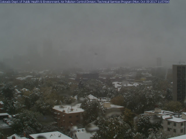
Our first significant cold front of the 2017 fall season arrives late tonight into early Tuesday morning. Latest indications are that the front will arrive between midnight to 3 a.m. CDT. There is a 30-40% chance for scattered showers and/or brief thunderstorms as the cold front pushes through the area generating lift (rising air). Behind the frontal boundary, a significantly cooler and drier air mass will invade the area from the north on breezy/gusty north winds. Winds will gust between 25-30 mph well into Tuesday morning. This same storm system is producing snow across Colorado today. Denver is currently a winter wonderland with between 4-6 inches of snowfall accumulation already being reported and it's still snowing. This is Denver's earliest reported snowfall in the past 5 years.

Denver Web Cam Shot taken at 1:00 p.m. CDT today (12:00 p.m. MDT):


Where is the front?
As of 1 p.m. CDT, the leading edge of the cold front is currently pushing through northwest Texas, just now reaching portions of the I-20 corridor. It's 55°F in Amarillo and 92° in Dallas.

Current Temperatures across the nation as of 1:00 p.m. CDT 


How much cooler?
Highs on Tuesday should only manage the 70s after starting the day in the 50s and 60s area wide. Lows Tuesday night into early Wednesday morning will dip into the 50s area wide with typically cooler locations dipping into the 40s. Highs on Wednesday should only manage the 70s to near 80 before the above normal temperatures return for the end of the week and the upcoming weekend. The average high/low for this time of year in Austin is 84/63.


Sunday, October 1, 2017

Rain Chances Returning

Forecast Discussion
Welcome to October! After a wet and dreary week, the sun finally came out this weekend across central Texas. Moisture will be on the increase as we start the new week. That increase in tropical moisture will lead to the chance for widespread showers and thunderstorms across the area on Tuesday and Wednesday. The clockwise wind flow around high pressure centered across the southeastern United States will allow for that tropical Gulf moisture to move into the area.

Rain opportunities Tuesday and Wednesday will be driven by daytime heating as there will be no focus (i.e. a cold front) for showers and storms to develop along. While I’m not expecting very impressive rainfall totals (generally between ½ to 1 inch of rain), some locally higher amounts will be possible for those locations that see more thunderstorm activity (rainfall rates higher in storms).


By Thursday, high pressure will begin to take control of our weather and allow for conditions to dry out and clear out.  

Long Range Outlook
The 8-14 day outlook courtesy of the Climate Prediction Center valid for October 9-15th is forecasting cooler than average temperatures and drier than average rainfall (see images below). True fall air may be right around the corner.

Temperature Outlook


Precipitation Outlook

Sunday, August 27, 2017

Tropical Storm Harvey | Sunday Evening Update

The Latest on Harvey

Hurricane Harvey Approaching the Texas Coast (Thursday-Friday)
GIF above courtesy of NASA Earth Observatory

As of 10 PM CDT, Harvey is still a tropical storm with maximum sustained winds at 40 mph. Harvey’s center of circulation (as of 10 PM) is located in between Edna and Port Lavaca (about 20-25 miles east of Victoria) and is inching closer and closer to the Texas Coast at 3 mph.

Harvey’s slight shift east and southeast is allowing for decreasing rainfall rates across the I-35 corridor as drier and more stable air moves in from the north on the western side of Harvey. This is good news for folks along the I-35 corridor, but bad news for folks across eastern sections of central Texas and southeast Texas where heavy tropical rain bands continue to regenerate and spiral into those already water-logged areas. The persistent rain that we have been experiencing all weekend long will become scattered on Monday and significantly lighter. The heaviest rain threat will continue to be focused across southeast Texas and the Houston Metro Area.

The latest official forecast track from the National Hurricane Center does show Harvey’s center of circulation moving back over the Gulf of Mexico sometime Monday before making a second landfall south of the Houston Metro Area (potentially in between Lake Jackson and Galveston), before tracking north through the Houston Metro Area as upper level steering conditions become favorable to pull Harvey north and out of the state of Texas by late Thursday into Friday. Check out the forecast graphic below for more detail (click/tap to make larger).


 Rainfall Totals as of 10 PM CDT Sunday Evening (past 48 hours)

Central Texas


Travis County
Camp Mabry | 7.33 inches
Austin Bergstrom International Airport | 10.42 inches
Lakeway | 4.60 inches
Jollyville | 6.64 inches
Bull Creek at Loop 360 | 6.33 inches
LCRA Redbud Center | 7.43 inches
Manor | 9.41 inches
Elroy | 12.83 inches

Hays County
Buda | 11.30 inches
Kyle | 8.79 inches
Driftwood | 7.38 inches

Bexar County
San Antonio International Airport | 2.01 inches
Bastrop County

Colorado River at Bastrop | 16.11 inches
Cedar Creek | 13.81 inches
Smithville | 21.86 inches
Fayette County

La Grange | 21 inches
Muldoon | 21.12 inches

Southeast Texas


Harris County
Houston Intercontinental Airport | 25.57 inches
Houston Hobby Airport | 25.86 inches

Observed Peak Wind Gusts/Rainfall Totals

Courtesy of the National Weather Service Austin/San Antonio Forecast Office