Forecast Discussion
Hello folks. I hope all of you had a wonderful Christmas holiday. Cold, Arctic Air has settled in across a large portion of the country. Modified Arctic Air has made it into central Texas and has helped to drop temperatures into the 30s and 40s across the area. Highs Wednesday only made it to 41ºF at Camp Mabry and Austin Bergstrom International Airport. As of Wednesday evening, temperatures have dropped into the 30s area wide with wind chills in the upper 20s to lower 30s.
7 p.m. Wednesday Evening Nationwide Temperatures
SLOW Warm-Up Ahead of New Year's Eve Arctic Cold Front
Temperatures over the next several days will slowly continue to rise ahead of an Arctic Cold Front that is forecast to arrive in Central Texas on New Year's Eve. Highs on Thursday will slowly "warm" back into the middle to perhaps upper 40s across the area under a mainly overcast sky, lower to middle 50s by Friday, and lower 60s by Saturday as southerly winds return to the area. The Arctic Cold Front looks to arrive late Sunday morning into early Sunday afternoon with rapidly falling temperatures and a gusty north winds. It looks like temperatures will be at or slightly below the freezing mark when the clock strikes midnight New Year's Day with wind chills in the teens and 20s across the area. Some forecast models are hinting there will be an opportunity for some freezing drizzle/rain and/or a few snow flurries New Year's Eve. We will need to watch this closely. We all know that it only takes a small amount of ice to wreak havoc on area roadways (especially elevated bridges and overpasses). Latest forecast model guidance is indicating that the majority of the precipitation should dry up just before temperatures drop below freezing in Austin, but it will need to be monitored closely. Especially if your travel plans take you north and west of Austin.
Forecast Upper Level Winds Favor an Arctic Air Mass to move south
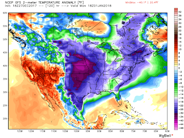
Forecast Temperature Anomaly (indicating well below normal temperatures across a large portion of the country early next week)
Arctic Cold to ring in 2018
A frigid Arctic air mass will remain entrenched across the area through at least the middle of the first week of 2018 keeping highs in the 30s Monday (New Year's Day) and Tuesday, most likely not much above freezing, with hard freezes likely during the overnight hours as temperatures are likely to drop into the lower to middle 20s across the region. You will need to make sure and wrap your exposed pipes as we have the potential to remain below freezing for long amounts of time.


No comments:
Post a Comment