Taking a look at latest water vapor satellite imagery, our next low pressure system that will be bringing us a good chance for widespread shower and thunderstorm activity is clearly visible spinning counter-clockwise over Arizona.

Here's a look at the latest visible satellite imagery as of 4:35 p.m. CST. Thunderstorms are starting to fire across portions of the Texas Panhandle. Do you see that clear spot out west of San Angelo in between Midland? That's the pocket of drier air I was mentioning that should give us a lull in the rainfall chances for this evening.

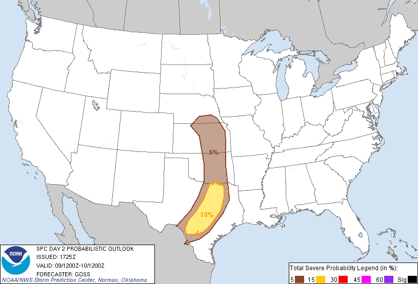
As that upper level low pressure system coupled with a surface low and a strong cold front push across the area late Saturday into the early-morning hours of Sunday, I am expecting a line of showers and thunderstorms to develop. Some of those storms that develop tomorrow evening/night will become strong or severe with damaging winds and large hail; an isolated tornado cannot be completely ruled out. The Storm Prediction Center (SPC) out of Norman, Oklahoma has placed all of central and north Texas (including the major metro areas along the Interstate 35 corridor) under the SLIGHT RISK CATEGORY for severe weather...areas shaded in yellow have the best shot at seeing severe weather.
CAPE Values will be on the moderate to high side across the area, therefore, the slight risk of severe weather must be included in the forecast. The higher the CAPE values the better the chance for severe weather. CAPE basically looks at how fast the air is rising; quickly rising air will form stronger storms.
.gif)
Saturday's Forecast:
Warm and moist southerly winds will pick up through the day as the storm system out west pushes closer to central Texas. Those breezy southerly winds will allow for temperatures to climb well into the 70s. South Texas will climb well into the 80s and lower 90s! Laredo's forecast high temperature for Saturday is 92°F. Skies will start cloudy on Saturday with mild temperatures in the upper 50s and lower 60s. Skies will turn partly sunny by afternoon with a 30% chance for scattered showers.
Latest high resolution forecast models are indicating that between 9 p.m. Saturday and 12:00 a.m. Sunday, storms will begin developing across the Hill Country and push their way across the Interstate 35 corridor after midnight. Behind the line of storms light to moderate rain will persist into the early morning hours of Sunday.
Forecast Radar Image at Midnight Sunday Morning: (Showers and Storms Developing out west)

Forecast Radar at 3 a.m. Sunday Morning (Showers and storms overhead):

Forecast Radar at noon Sunday (Rain pushing east of central TX):

Skies will slowly clear through the day on Sunday as much drier and cooler air filters into the region on strong northerly breezes. Lows will fall into the 30s and 40s Sunday night with highs only managing the 60s on Monday under a sun-filled blue sky. Temps drop into the 30s area wide Monday night; some low-lying and out-lying areas may receive a light freeze.
So, how much rain are we talking? The latest NAM model is not very impressive with much of the area receiving 1/4 inch or less of rainfall. The GFS Model is much more optimistic, forecasting a widespread 1/2 to 1 inch of rainfall across the area (I personally believe most will end up with at least a half an inch of rain).
GFS Forecasted Rainfall Accumulation: (Check out the KEY to see how much rainfall your area is forecasted to see)

No comments:
Post a Comment