
What causes these massive sandstorms?
In particular, let's focus on the recent Western Australia Sandstorm. Below are the photos of the massive sandstorm that struck portions of western Australia.


First, let's take a look at the general landscape of Australia. Deserts make up 44% of the continent of Australia; another 37% of Australia is made up of semi-arid conditons and grasslands. Add both those numbers up and nearly 81% of Australia is made up of desert/semi-arid conditions. Deserts are classified as an area that receives less than 10 inches of rain a year. Check out all of the red sand across Australia (clearly visible on high resolution satellite imagery). The area circled in yellow is where the dust storm occurred.

Several factors came together this past Wednesday in Australia to lead to the incredible show that Mother Nature put on. First, Australia has been dealing with one of their worst, if not the worst, heatwave on record. Remember, it is summer in the southern hemisphere right now. This past Monday, Australia sweltered through its hottest day on record with a nationwide average temperature of 104.5°F (40.3°C), breaking the previous record of 104.3°F set back in 1972. Four of Australia's hottest 10 days have just been recorded this year! Believe it or not, the Australian Weather Bureau had to add new colors to their temperature maps to accomodate the insanely high temperatures that baked central portions of Australia. Temps exceeded 122°F in central Australia earlier this week. Purple blob in the center of Australia forecasted temperatures above 122°F (50°C) across central Australia earlier this week. Incredible!


Extremely dry conditions, gusty winds, and extreme heat have allowed for numerous wildfires to burn out of control across Tasmania and southeastern Australia...Sydney, Australia (located along the southeastern coastline of Australia) is expected to hit 102°F later this afternoon before a big cool down arrives tomorrow and lasts through the majority of next week. The average high for Sydney in January is 78°F.

Sydney, Australia Skyline:

Australia has got a lot going on right now in the weather department. Heatwaves, fires, winds, and tropical cyclones!
Just to the north and west of the area that experienced the large sandstorm on Wednesday is Tropical Cyclone Norelle with sustained winds of 125 mph (Category 3 Hurricane Strength)...hurricanes in the northern hemisphere spin counter-clockwise, however, in the southern hemisphere, they spin clockwise.

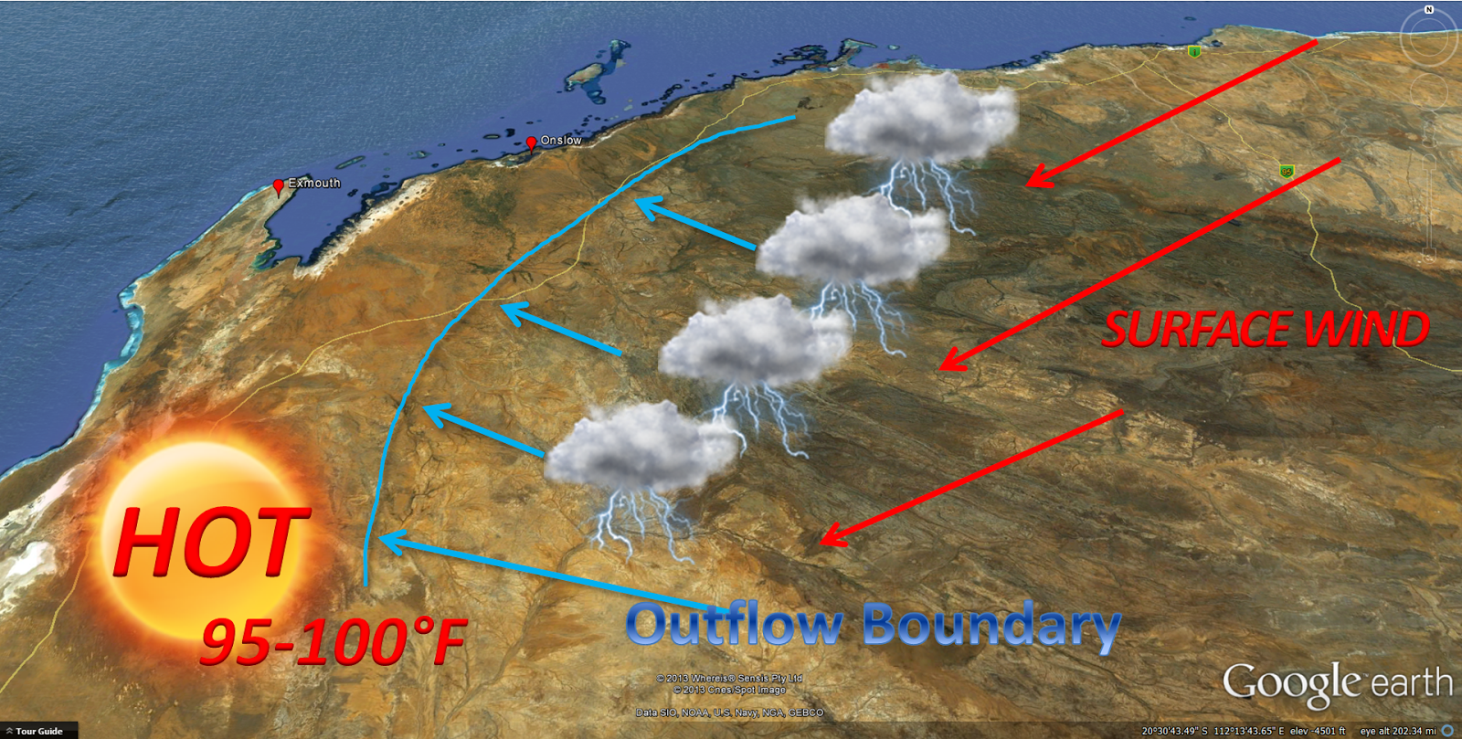
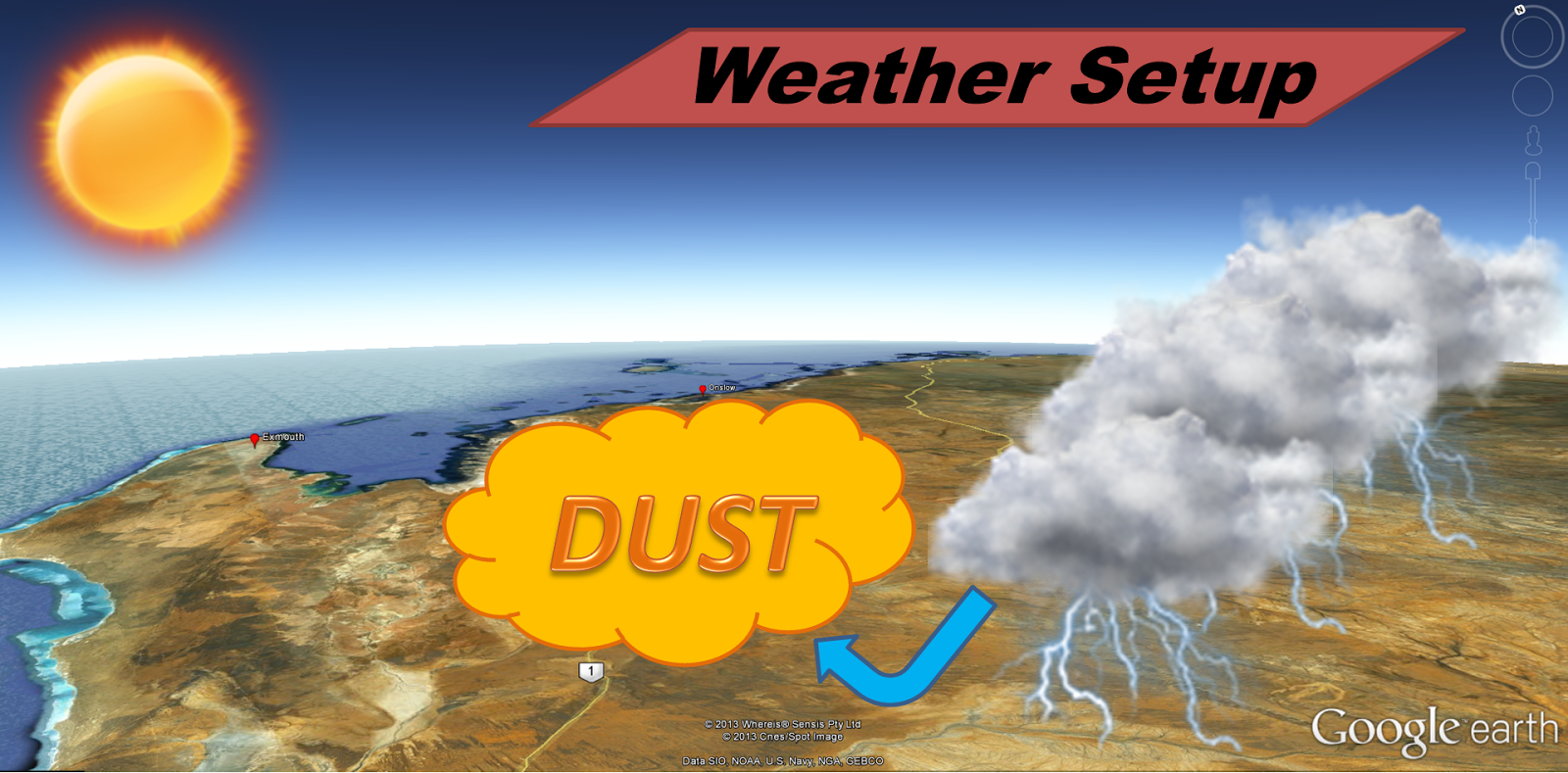
The clockwise flow around Norelle and the counter-clockwise flow around the massive dome of high pressure sitting on top of central Australia, allowed for a east northeasterly surface wind flow to develop across western Australia, as that hot, dry air moved from inland Australia towards the coast, it runs into some mountain ranges, the air is forced to rise as it hits the higher elevations producing a weather setup known as orographic lift. The orographic lift combined with the intensely hot temperatures (which produce enough lift by themselves) forced showers and thunderstorms to develop east of the coastline...as these storms died, they sent out a rush of cold air, a downdraft. Since cold air is much denser than warm air, it rapidly falls from the base of the thunderstorm towards the desert floor. Once the cold air hits the desert floor and mixes with the warm air, the battle is on between hot and cold. Therefore, strong, gusty winds develop. Those wind gusts, which exceeded 60 mph, picked up the dust and sand across the desert floor, in turn creating a massive sandstorm. The rush of cool air out of the dying storms is known as an outflow boundary, a mini cool front. Outflow boundaries are very typical here in central Texas during the summer months with short-lived showers and storms during summer afternoons. Because, we do not live in a desert, there is no sand to be picked up.
Tropical Cyclone Norelle will remain off the coast of western Australia, however, folks along the western coast of Australia will experience gusty winds and torrential tropical downpours. Another tropical cyclone looks to affect northwestern Australia by the middle to end of next week.
500mb weather maps clearly show the massive ridge of high pressure over Australia and Norelle! Norelle is located in the left-hand side, circular area of red and yellow. Upper level winds around the high will keep Norelle off of the coast and swing it south of Australia by next week.

Great impressive pics....thank you ...I lived in W. Australia back 1970s ...brought back great memories of Sand Storms near Southern Cross
ReplyDeleteThis is a fascinating look at how weather patterns can create such dramatic events.
ReplyDelete