
Today's weather setup: Warm and dry southwesterly winds allowed for highs to climb into the 80s this afternoon.


Tonight, a cool front will blow through the region and turn winds out of the north, allowing for much cooler air to infiltrate the region by morning when we will wake up to temperatures in the 30s and 40s. We should be in the lower to middle 40s here in Austin tonight with highs climbing into the upper 60s to near 70°F for Tuesday afternoon under a mostly sunny sky.

As a the jet stream takes a dip south and an upper level storm system riding it approach us from the west, clouds will begin to increase from the west late in the day on Tuesday, signifying our change in weather. In fact, showers are possible overnight Tuesday into Wednesday morning and through the day on Wednesday. There is a 60% chance for showers on Wednesday. That cold front that is blowing through the area tonight will move back north on Wednesday as a warm front and really kick up the winds out of the south southeast across the area. Those southerly winds off of the Gulf of Mexico will allow for muggy air to return to central Texas. Late Wednesday into early Thursday, a Pacific Front will sweep through the area from west to east. There is a 50% chance for showers and storms to develop along the front late Wednesday. Heaviest weather looks to stay north of central Texas, however, we will still have to watch out for the chance for an isolated strong or severe storm with hail and high winds being the biggest threats. The Storm Prediction Center has placed the northern half of central Texas, from San Marcos north, including the Austin Metro Area, under the SLIGHT RISK CATEGORY for severe weather.


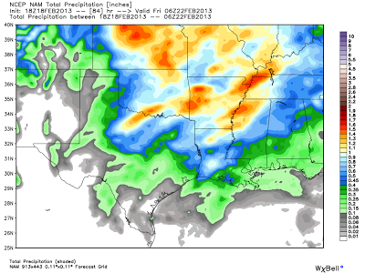
Now, how much rain are we talking. The latest NAM model is forecasting around 0.25 inches of rainfall on average for central Texas with some areas looking to receive even less. However, the GFS Model is forecasting anywhere from 0.25 to as much as an inch of rainfall possible across central Texas, with highest totals falling east of the 35 corridor. Keep your fingers crossed that the GFS verifies because we can use every drop of water that we can get!
NAM Model Forecast Rainfall Accumulation:
GFS Model Forecast Rainfall Accumulation:

NAM Model Forecast Rainfall Accumulation:

GFS Model Forecast Rainfall Accumulation:

Behind the Pacific Front on Thursday, dry and warm westerly winds will kick in and allow for temperatures to climb into the 70s. Highs on Wednesday will only be in the 60s (which is normal for this time of year).
Latest seven day forecast:

Latest seven day forecast:

No comments:
Post a Comment