Sunday, August 27, 2017

Tropical Storm Harvey | Sunday Evening Update

The Latest on Harvey

Hurricane Harvey Approaching the Texas Coast (Thursday-Friday)
GIF above courtesy of NASA Earth Observatory

As of 10 PM CDT, Harvey is still a tropical storm with maximum sustained winds at 40 mph. Harvey’s center of circulation (as of 10 PM) is located in between Edna and Port Lavaca (about 20-25 miles east of Victoria) and is inching closer and closer to the Texas Coast at 3 mph.

Harvey’s slight shift east and southeast is allowing for decreasing rainfall rates across the I-35 corridor as drier and more stable air moves in from the north on the western side of Harvey. This is good news for folks along the I-35 corridor, but bad news for folks across eastern sections of central Texas and southeast Texas where heavy tropical rain bands continue to regenerate and spiral into those already water-logged areas. The persistent rain that we have been experiencing all weekend long will become scattered on Monday and significantly lighter. The heaviest rain threat will continue to be focused across southeast Texas and the Houston Metro Area.

The latest official forecast track from the National Hurricane Center does show Harvey’s center of circulation moving back over the Gulf of Mexico sometime Monday before making a second landfall south of the Houston Metro Area (potentially in between Lake Jackson and Galveston), before tracking north through the Houston Metro Area as upper level steering conditions become favorable to pull Harvey north and out of the state of Texas by late Thursday into Friday. Check out the forecast graphic below for more detail (click/tap to make larger).


 Rainfall Totals as of 10 PM CDT Sunday Evening (past 48 hours)

Central Texas


Travis County
Camp Mabry | 7.33 inches
Austin Bergstrom International Airport | 10.42 inches
Lakeway | 4.60 inches
Jollyville | 6.64 inches
Bull Creek at Loop 360 | 6.33 inches
LCRA Redbud Center | 7.43 inches
Manor | 9.41 inches
Elroy | 12.83 inches

Hays County
Buda | 11.30 inches
Kyle | 8.79 inches
Driftwood | 7.38 inches

Bexar County
San Antonio International Airport | 2.01 inches
Bastrop County

Colorado River at Bastrop | 16.11 inches
Cedar Creek | 13.81 inches
Smithville | 21.86 inches
Fayette County

La Grange | 21 inches
Muldoon | 21.12 inches

Southeast Texas


Harris County
Houston Intercontinental Airport | 25.57 inches
Houston Hobby Airport | 25.86 inches

Observed Peak Wind Gusts/Rainfall Totals

Courtesy of the National Weather Service Austin/San Antonio Forecast Office


Friday, August 25, 2017

Hurricane Harvey

Hurricane Harvey Update
Impacts on central/south central Texas

I’m really concerned about 3 things for central/south central Texas (Austin/San Antonio Metro Areas)

  • Dangerous/potentially deadly historical rainfall accumulation/flash flooding 
  • Strong, gusty winds that will likely bring power outages
  • A few tropical tornadoes possible


As of 1:00 PM CDT Friday afternoon, the eye of category 2 Hurricane Harvey is currently located 65 miles southeast of Corpus Christi, TX and moving northwest at 10 mph…maximum sustained winds as of the 1 PM CDT update from the National Hurricane Center were sustained at 110 mph gusting to 130 mph.

Per the 1 PM CDT Update from the National Hurricane Center, Harvey is still expected to make landfall as a major category three hurricane with winds sustained at 120 mph gusting to 150 mph late tonight into early Saturday morning most likely somewhere in between Corpus Christi and Port O’Connor. Instead of moving through quickly, Harvey is going to move slightly inland or hug the coast through the weekend. This will only work to exacerbate flooding and storm surge concerns for coastal areas and inland areas well away from Harvey’s center. Hurricane Force Winds (74 mph +) currently extend outward up to 35 miles from Harvey’s center, and tropical storm force winds (39-73 mph) extend outward up to 140 miles per hour.

Latest Visible Satellite Image of Harvey (NASA GOES-16)


Latest Doppler Radar Imagery
Counties shaded in pink along the coast are under a TORNADO WATCH until 2 AM CDT Saturday Morning


Latest Forecast Track from the National Hurricane Center


Projected Rainfall Accumulation from Harvey through Tuesday


Local Statement on Hurricane Harvey from the NWS Austin/San Antonio Forecast Office as of 1:31 PM CDT

Current Watches and/or Warnings
A Tropical Storm Warning is in effect for Atascosa, Bastrop, Bexar, Caldwell, Comal, Fayette, Gonzales, Guadalupe, Hays, Lavaca, and Wilson counties until further notice.
Harvey is still moving slowly northwestward in the Gulf of Mexico,
currently as a strong category 2 hurricane, and continuing to
strengthen as it approaches the Texas coastline. This northwestward
movement is expected to continue and Harvey should make landfall
Saturday morning. Confidence remains high in a major rainfall event
taking place across much of South Central Texas, in addition to some
locations closer to the coast experiencing hurricane force and tropical
storm force winds.

At this stage, a life-threatening and catastrophic heavy rainfall
event appears imminent for much of South Central Texas east of
Interstate 35 and Interstate 37.
This could lead to significant flash
flooding across these areas. Average storm total rainfall amounts of
10 to 20 inches are expected east of Interstate 35 and Interstate
37 today through Tuesday. Isolated higher amounts in excess of
25 inches are possible near and south of the Interstate 10 corridor.


For the Interstate 35 corridor and the eastern Hill Country, including
the cities of San Antonio and Austin 6 to 12 inches are forecast with
isolated higher amounts.

Harvey is expected to stall or move very slowly over the area. With
these forecasted rainfall amounts catastrophic river flooding is also
very likely east of Interstate 35 and south of Interstate 10 in the
Colorado, Guadalupe, and San Antonio river basins.

Additionally, hurricane force winds of 70 to 80 mph will be possible
for the counties within the Hurricane Warning. 40 to 50 mph winds with
some gusts to 60 mph, in the tropical rain bands, will be possible for
areas within the Tropical Storm Warning including San Antonio and San
Marcos. The Austin area could see winds of 20 to 30 mph with gusts to
40mph within rain bands. The timing of these winds look to arrive
Friday night through Saturday morning. There is a low risk of brief
tornadoes east of Interstate 35 and south of Interstate 10 Friday
evening into the weekend associated with tropical rain bands.


Thursday, July 27, 2017

Brutal Heat ahead of Hopeful Pattern Change

Forecast Discussion
We officially topped out at 103°F Thursday afternoon in Austin at Camp Mabry and 101°F at the airport. Today makes our 24th day of triple digit heat in Austin for 2017 and our 10th day in a row of 100°+ heat. We’ve got two more really hot days on tap before a gradual weather pattern change occurs for the second half of the weekend and into next week.

The hottest official temperature recorded in Austin so far this year has been 104°F set back on June 23rd and July 21st (both reached at Camp Mabry). We have a very good chance of hitting 104°F again in Austin tomorrow (Friday) and an even better chance of exceeding 104°F on Saturday as the relentless summer heat builds more ahead of an approaching weak late July cool front. The only sliver of good news is that slightly drier afternoon air is helping to keep heat indices (feels like temperatures) from climbing to crazy high levels.

Friday Forecast High (Austin/Camp Mabry): 104°F (record high = 105°F set back in 1923)
Saturday Forecast High (Austin/Camp Mabry): 105°F (record high = 105°F set back in 1923)

Saturday's Forecast Highs (High Resolution North American Model)
Late Weekend/Early Next Week Rain Chances
A weak frontal boundary in the area combined with weak upper air disturbances may allow for some scattered showers and thunderstorms to develop around the area on Sunday and Monday. While severe weather is not expected, summertime thunderstorms still pose a hazard with deadly cloud to ground lightning, brief heavy rainfall, small hail, and gusty winds.

Medium to Long Range Outlook
The Climate Prediction Center in their 6-10 day outlook is continuing to indicate below normal temperatures and above normal precipitation for Texas August 2-6 and potentially beyond. We will wait to see if those long range forecasts verify. Medium to long range forecast models are hinting that the big dome of high pressure that has been controlling our weather for the past several weeks will begin to shift west and allow for low pressure to take its place. Low pressure promotes rising air which promotes the development of clouds and hopefully beneficial rains. Let’s keep our fingers crossed.

Texas Drought Update

Moderate to severe drought conditions have returned to central and south central Texas as noted on the Drought Monitor’s latest update (see below)


Saturday, April 29, 2017

Severe Thunderstorm Risk This Evening

Forecast Discussion
Good afternoon folks! Another very warm spring day in progress across central and south central Texas ahead of an approaching upper level disturbance and its associated surface cold front. As of the 3 p.m. update at both Camp Mabry and Austin Bergstrom International Airport the temperature is 90°F with a feels like temperature of 97°F thanks to the very soupy Gulf air mass in place thanks to strong southerly winds feeding this approaching storm system.

Severe Weather Threat this Evening
DETAILED FORECAST DISCUSSION
The atmosphere is very unstable across the area right now, however, a strong capping inversion, or lid on the atmosphere, is currently holding strong across the area. The leading edge of the cold front is currently pushing through the far western Hill Country and has already moved through places like Llano and Junction where temperatures are closer to 80°F with breezy northwesterly winds in place.

The upper level energy with this approaching storm system is still located across west Texas, but is beginning to rapidly move east towards the I-35 corridor. The latest high resolution forecast models continue to indicate that storms will initially have a hard time developing for areas along and west of the I-35 corridor in central Texas late this afternoon and evening given the strong capping inversion in place, however, the models do indicate that storms may have an easier time developing once the front crosses the I-35 corridor and moves into eastern sections of central and south central Texas.

Because the atmosphere is so unstable across the area, any storm that is able to get going this afternoon/evening, will have a good chance of becoming severe with large hail and damaging winds. Storms will initially be isolated to scattered in nature this afternoon/evening, but likely to increase in coverage as they move along and east of the I-35 corridor. With this in mind, please remain weather aware and have a way to receive any watches and/or warnings issued by the National Weather Service.

Severe Weather Risk Outlook
Given the threat of severe weather, the Storm Prediction Center has placed counties along and east of the I-35 corridor in the SLIGHT RISK (yellow shaded region) category for potential severe weather this afternoon/evening...an ENHANCED RISK (orange shaded region) of severe weather has been put in place for areas well north and east of the Austin Metro Area where severe weather is more likely to develop.


Storm Timeline
Between 4pm-Midnight scattered storms will be possible, some of which may be severe with large hail and damaging winds...keep an eye to the sky this evening. The storms that develop between now and midnight will be the ones that have the best potential of bringing severe weather.

Midnight-7 a.m. Sunday Morning additional showers and thunderstorms may move across the area, however, these are not likely to be severe, but one or two may be on the strong side

Conditions rapidly clear from west to east early Sunday morning as much drier and cooler air infiltrates the region on breezy northwesterly winds...highs Sunday only in the 70s with lows dipping into the 40s and 50s by early Monday morning. It's going to feel great!

Saturday, April 1, 2017

Severe Weekend Weather

Forecast Discussion
A potent upper level low spinning over the desert southwest is approaching the state of Texas from the west. Out ahead of this upper level storm system, Gulf of Mexico moisture is streaming north into our area as evidenced by the widespread clouds and patchy sprinkles across the area this afternoon. This approaching upper level low combined with Gulf moisture and a surface frontal system will work together to produce widespread showers and thunderstorms across the area beginning late tonight across west Texas and shifting into central Texas Sunday morning/afternoon. The storms that develop are very likely to be strong/severe capable of producing all modes of severe weather (large hail, damaging winds, and tornadoes). Along with the threat of severe weather, torrential downpours and localized areas of flash flooding will be possible.

Sunday Severe Risk
The Storm Prediction Center has placed areas east of Austin from Milam, Lee, and Fayette Counties to southwestern Louisiana including the Houston Metro Area and Bryan/College Station area under a MODERATE RISK for severe weather on Sunday. This is a threat level 4 on the severe weather risk scale.

The Storm Prediction Center has placed the I-35 corridor from Waco to San Marcos (including the Austin Metro Area) under an ENHANCED RISK for severe weather on Sunday. This is a threat level 3.

The Storm Prediction Center has placed the Hill Country west of the Austin Metro Area under a SLIGHT RISK for severe weather on Sunday. This is a threat level 2.


THREAT LEVEL 4: MODERATE RISK (red shaded region)
Widespread, intense, and long-lived severe storms likely; strong tornadoes possible along with widespread wind damage and destructive hail in excess of 2 inches in diameter...Houston Metro Area included in this category

THREAT LEVEL 3: ENHANCED RISK (orange shaded region)
Numerous severe storms possible (storms will be more persistent and/or widespread, a few of the storms will be intense capable of producing a few tornadoes, several reports of wind damage and damaging hail between 1-2 inches in diameter...Austin Metro included in this category

THREAT LEVEL 2: SLIGHT RISK (yellow shaded region)
Scattered severe storms possible, short-lived and/or not widespread, isolated intense storms possible capable of producing one or two tornadoes, reports of strong winds/wind damage, and hail of about, but not limited to 1 inch in diameter...San Antonio Metro included in this category

***We need to remain weather aware over the next 24-36 hours across central and south central Texas. The chance for significant severe weather is in place. Please have a way of receiving severe weather alerts. If you have turned off your emergency alerts on your cell phone, this is a good time to turn those alerts back on, they may end up saving your life***


Tuesday, March 28, 2017

Severe Weather Risk Overnight

Forecast Discussion
…risk of strong and/or severe thunderstorms across central and south central Texas late tonight into early Wednesday morning
…strongest storms will be capable of producing large hail, strong gusty winds, torrential downpours, and dangerous cloud to ground lightning…
…an isolated tornado cannot be ruled out, but does not appear to be likely at this time…
…overall, 0.50-1.50 inches of rain can be expected across the area…flooding threat appears to be low at this time given the progressive (fast-moving) nature of this storm system…

Severe Weather Threat
The Storm Prediction Center (SPC) has placed areas along and west of the I-35 corridor (including the Austin Metro Area) under a SLIGHT RISK for severe weather late this evening and overnight...MARGINAL RISK for areas south and east of Austin.

The greatest threat for severe weather and tornadoes will be across west Texas and especially northwest Texas from Abilene to Wichita Falls to Childress where they are under a MODERATE RISK for severe weather (red shaded region).


Understanding Severe Risk Categories 
…the slight risk outlook is considered a threat level 2 in the 5 threat severe weather outlook system.
1.      Marginal
2.      Slight
3.      Enhanced
4.      Moderate
5.      High
(See chart below for a more detailed understanding of each threat level)


Detailed Forecast Explanation
A potent upper level low pressure system and its attendant cold front will move from west to east across the area during the overnight hours tonight lifting the warm, muggy, and unstable air mass currently in place across the area. The lift associated with this low pressure system at the mid and upper levels of the atmosphere will work together with surface lift provided by an eastward moving cold front to produce a line of thunderstorms across west Texas that will march east towards central Texas late tonight/early Wednesday morning. Some of the embedded storms within this line of storms are expected to be severe as they move across the area late tonight (especially across the Hill Country).

Storm Timeline
10pm to Midnight | Storms approach the western Hill Country
Midnight to 2am | Storms moving through the Hill Country…approaching Travis, Hays, and Williamson Counties
2am to 5am | Storms moving through the I-35 corridor and counties just east of the I-35 corridor
5am to 7am | Storms moving through eastern areas of central Texas
After 7am | Storms exiting the area to the east as drier and more stable air infiltrates the region from the west…clearing skies expected midday Wednesday

Forecast Radar (2 a.m. Wednesday morning)

Wednesday, March 22, 2017

Thunderstorm Risk Friday

Weather Re-Cap 
Good Evening Folks! It's another warm and breezy March afternoon across the area. Wednesday's official high temperatures are coming in at 83°F at both Camp Mabry and Austin Bergstrom International Airport. We started the day on a very mild note with temperatures in the mid to upper 60s.

An approaching upper level Pacific storm system (currently located along the west coast) is traveling east and will be increasing our chances for showers and thunderstorms across the area late Thursday into Friday. Ahead of Friday's storm chance, breezy southerly winds can be expected across central and south central Texas on Thursday. Southerly winds gusting 25-30 mph will be possible. Those southerly winds will be transporting plentiful amounts of Gulf of Mexico moisture into the area out ahead of Friday's showers and thunderstorms.

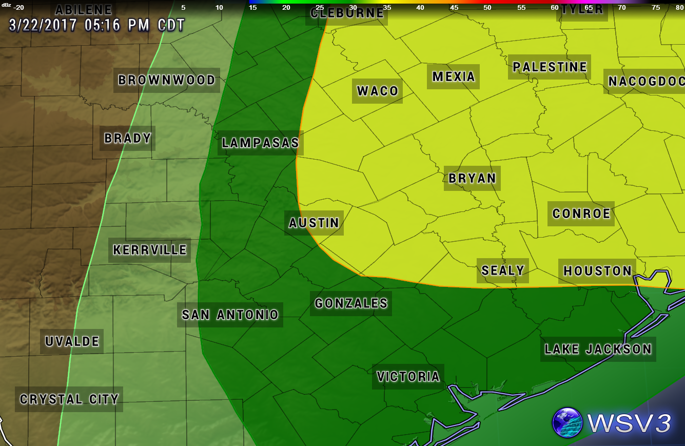
Friday Severe Weather Risk
Overall, the severe weather risk is looking to be fairly low for all of central Texas on Friday, however, one or two strong/potentially severe storms cannot be ruled out along and especially east of the I-35 corridor.

The Storm Prediction Center (SPC) has placed the area in the MARGINAL to SLIGHT Risk category for potential severe weather on Friday. The Marginal Risk area encompasses the eastern Hill Country down through San Antonio and to the Gulf Coast. The Slight Risk area encompasses areas from Austin to the north and east.

MARGINAL RISK = DARK GREEN SHADED AREA (5% risk of severe weather)

  • Isolated severe thunderstorms possible (limited in duration and/or coverage/intensity)
  • Low tornado risk
  • Hail up to 1" in diameter (quarter-sized)
  • Thunderstorm wind gusts of 40-60 mph

SLIGHT RISK = YELLOW SHADED AREA (15% risk of severe weather)

  • Scattered severe storms possible (short-lived and/or not widespread, isolated intense storms possible)
  • One or two tornadoes possible
  • Reports of strong winds/wind damage possible
  • Hail of about 1" in diameter possible, isolated 1.5-2" possible
Severe Weather Threat Map (valid late Thursday Night into Friday)


Storm Timeline
Per the latest forecast model guidance, a line of storms is likely to develop across west Texas late Thursday night and push east towards the I-35 corridor during the overnight hours. The high resolution North American Forecast Model has the line of storms moving through the: 
  • Hill Country between 4-9 a.m. CDT Friday morning and pushing 
  • through the I-35 corridor, including the Austin and San Antonio Metro Areas between 9-NOON CDT Friday
  • and 1-5 p.m. CDT for areas east of Austin.
Forecast Radar 10 a.m. CDT Friday (shows a line of storms along the I-35 corridor from Dallas to San Antonio)


Forecast Rainfall Accumulation
Generally less than an inch for most, 0.25-0.50 is a good bet for most locations (especially along and east of the Highway 281 corridor)...higher totals east, lower totals west

After Friday's Storms
Showers and thunderstorms should come to an end along the I-35 corridor by early Friday afternoon with clearing skies expected from west to east during the afternoon hours, a weak cool front will move through the area late Friday night/early Saturday morning and usher in some slightly cooler and drier air into the area for the first half of the weekend...lows in the 50s expected early Saturday morning and again on Sunday morning with highs in the 80s...storm chances increase a bit Sunday night with another disturbance and again for the middle of next week. Plenty of time to watch that.