Forecast Discussion
A potent upper level low pressure system currently moving over New Mexico promises to bring widespread shower and thunderstorm activity to central Texas late tonight into Tuesday morning. Dynamic upper level atmospheric lift provided by the approaching upper level low pressure system and its attendant surface low and attendant cold front will force air to rise over the area and produce showers and storms. Some of the storms that develop tonight/early Tuesday morning will have the potential to become severe with large hail of up to an inch in diameter and gusty thunderstorm wind gusts in excess or equal to 58 mph.
Current Position of Upper Level Storm System (500 mb height map/mid/upper level water vapor imagery)
Image courtesy of the University of Arizona
The Storm Prediction Center out of Norman, Oklahoma has placed a good majority of central Texas, including the Austin Metro Area, under a MARGINAL RISK for severe weather. Areas south and west of Austin, including San Antonio and points west to the Texas-Mexico Border have been placed under a SLIGHT RISK for severe weather (see map/definitions below)
Marginal Risk: "Isolated severe storms possible...limited in duration and/or coverage and/or intensity...winds 40-60 mph possible, hail up to 1" in diameter possible, low tornado risk"
Slight Risk: "Scattered severe storms possible...short-lived and/or not widespread, isolated intense storms possible, one or two tornadoes possible, reports of strong winds/wind damage possible, hail of 1" in diameter as large as 2" in diameter possible"
Forecast Rainfall Accumulation
Latest forecast model guidance indicating that we could receive a widespread 1-2 inches of rain across the area tonight through noon Tuesday. Given our drought conditions, that would be a welcome sight.
Flooding should NOT be a major issue tonight, however, some urban street flooding, especially in typical poor drainage areas may become dangerous overnight as the heaviest of the rainfall is expected to move through.
Weather Set Up
A weak cool front moved through the area yesterday evening and has now stalled out to our south...that boundary will lift back north tonight ahead of the upper level storm system and allow for southerly winds to increase over the area. Returning southerly winds will only help to prime the atmosphere over the area for showers and thunderstorms.
As the potent upper level storm system/disturbance moves across the area from west to east, a line/complex of storms will push east with it. As it looks to me, the heaviest storms/storms with the greatest potential of producing severe weather may stay south of Austin, potentially affecting the San Antonio Metro Area and points south the hardest. You can clearly see that on the latest run of the High Res Radar...check out that nasty bowing line of storms southeast of San Antonio with lots of moderate/heavy rainfall across central Texas.
Forecast Radar 1 a.m. Tuesday Morning (HRRR Model...High Resolution Rapid Refresh Model)
Image courtesy of WeatherBell Models
WINDY/Cooler Tuesday and Wednesday
On the back side of this disturbance a windy cold front will sweep through the area and really kick up the winds for your Tuesday, especially Tuesday afternoon when winds could easily gust above 40 mph across the area. With that being mentioned, the National Weather Service has issued a WIND ADVISORY for all of central and south central Texas
Significantly cooler and drier air will pour into the area Tuesday afternoon on those strong, gusty winds.
Let's remain weather aware over the next 24-36 hours as this storm system and cold front move through the area.
Please remember to heed all watches/warnings/advisories issued by the National Weather Service. They issue these for your safety and the protection of your property.
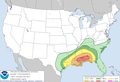
Southeastern US/Gulf Coast Potential Tornado Outbreak Tuesday:
As this same storm system travels east during the day on Tuesday, there is the potential for a dangerous/deadly tornado outbreak across the Gulf Coast/Southeastern United States. The Storm Prediction Center has placed areas along the Gulf Coast under a MODERATE RISK for severe weather. The Storm Prediction Center/National Weather Service defines a moderate risk of severe weather like this: "Widespread severe storms likely...long-lived, widespread, and intense. Strong tornadoes, widespread wind damage, and destructive hail of 2 inches in diameter and greater possible"


No comments:
Post a Comment