Forecast Discussion:
Good
Wednesday evening everybody. We have got some changes on the way and they are
not all that far away. I’m watching a fairly strong August cold front making
its way south down Interstate 35 right now…the front has already passed through
the DFW Metroplex and will continue to push south through the evening and into
the overnight hours…this is a fairly strong cold front for mid-August, places
like Oklahoma City are sitting in the upper 60s to lower 70s right now with a
nice cool dry breeze. They will be dipping into the 50s tonight! How nice does
that sound?
3 p.m. Temperatures Across the lower 48, check out the swath of cooler temps across the middle of the country!

Visible satellite, radar, and wind barb composite map across the state as of the 4 pm hour with cold front position superimposed on top, notice the breezy north winds across the DFW Metroplex, storm graphics indicate scattered convection (showers and storms) possible through the evening into the day on Thursday:
Image is courtesy of GREarth

What's driving this abnormally strong August cold front? The answer is a big dip in the jet stream out of Canada which is more typical of spring and fall, not summer...this dip in the jet stream, also known as a trough of low pressure, acts as an atmospheric valley and pulls cool air from the north down into the lower 48...you can see that dip, or trough clearly on this 500mb (18,500 feet) upper air pressure map, if any of you are familiar with reading topographic maps, you know that the closer the lines are together, the steeper the mountain/cliff being represented, it can be thought of in the same way with air...areas of high pressure are like mountains while areas of low pressure act more like valleys: The big area shaded in blue represents the trough, or dip in the jet stream

What
does this front mean for us here in central Texas?
In
simple terms, as the front continues to move south, our warm, moist, and
unstable air mass will be forced to rise…the lift produced along the frontal
boundary will allow for scattered showers and thunderstorms to develop across
the area later this evening and into the overnight and early morning hours on
Thursday. A few of the storms that develop will have the potential to become
strong, or possibly severe with pocket-change sized hail and damaging wind
gusts being the primary concerns in addition to deadly cloud to ground
lightning and the potential for some brief, localized heavy downpours that may
create some street ponding. Rainfall accumulation will be fairly scattered with
most areas generally receiving less than 0.25 inches of rain, however, there is
the potential for some locations to receive over an inch of rain with any heavy
storms that are able to get going or any storms that develop and sit over the
same area or train, meaning storms that move repeatedly move over the same
areas again and again like a train on tracks.
Behind
the front on Thursday winds will turn to the north northeast across central
Texas and allow for highs to drop into the mid to upper 80s compared to the mid
to upper 90s that we are experiencing today. With the frontal boundary stalling
just south of the area, the potential for additional scattered showers and
storms will be possible across the area during the day Thursday…strongest
activity should be confined to our south and southeast along and ahead of where
the actual frontal boundary decides to stall out.
Unfortunately
the mini cool down will be brief as long range forecast models continue to
indicate a return to typical hot August weather as the large blocking ridge of
high pressure that has been sitting over us for much of the summer returns
again…models show us easily returning into the upper 90s and lower 100s by the
weekend into next week.
Ridge Building = Heat Building and Rain Chances Dropping:

Tropical
Update:
Tropical
Storm Danny has developed out in the mid-Atlantic and is making weather
headlines because of the lack of tropical activity this year across the
Atlantic. We can thank a strengthening El Niño for that which tends to increase
atmospheric pressure over the Atlantic and contribute to stronger than normal
wind shear (wind that changes speed and direction with height)…wind shear
effectively rips the tops off of developing tropical systems which ultimately
allows them to fall apart, weaken, or not even have a shot at developing.
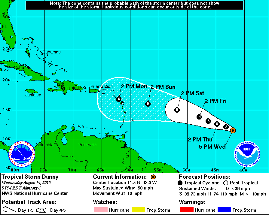
Latest Forecast Track for Tropical Storm Danny with maximum sustained winds of 50 mph traveling west at 10 mph, likely to become a category one hurricane by Friday as it continues to push west with sustained winds of 75-80 mph:
Active Pacific Storm Season thanks to El Niño:
The
same cannot be said for the Pacific, as this year is challenging records…warmer
than normal waters across the Equatorial Pacific create lots of evaporation and
rising air and allow areas of low pressure to develop and flourish, hence the
reason for such an active tropical weather year across the Pacific. Two monster
super typhoons across the eastern Pacific making headlines are Super Typhoon
Goni and Super Typhoon Atsani…they are both equivalent to a category 4
hurricane, although Atsani is nearing category 5 status. A typhoon is just a
different name for a hurricane that is used across the eastern Pacific. There
is no difference between a hurricane and typhoon other than their names. They
are both warm core tropical areas of low pressure that develop in response to
the unequal heating of the earth…warm at the equator, cold at the poles…hurricanes
and typhoons are simply ways of moving excess heat from the tropics into
cooler, northern latitudes.
Here
are two very impressive Infrared satellite shots of Super Typhoon Goni and Super
Typhoon Atsani via Japan’s Himawari Satellite, you can clearly see the eyes of
both of these monsters!
Labeled
Version (monochrome):

False
Color Background with IR Satellite imagery superimposed:

No comments:
Post a Comment