Wednesday, June 24, 2015

JUNE COLD FRONT...WEEKEND STORM CHANCE

FORECAST DISCUSSION:
Good Wednesday afternoon everybody…I hope you all are doing well. Another typical warm and muggy June day in progress across the area with temperatures in the upper 80s and lower 90s…high dew points making it feel more like it’s in the upper 90s to near 100°F…sea breeze moving up into the Austin Metro Area as of 4:53 pm CDT will likely kick off a tiny shower or two as it moves through the metro area within the next hour…heaviest sea breeze activity is confined to our southeast across Fayette County where a fairly heavy downpour with some lightning and sub-severe gusty winds has developed. The rain chance at any one location this evening is 20%, dropping below 10% after 7 pm as we begin to lose the heat of day. Additional sea breeze showers and thundershowers possible again on Thursday.


Radar Snapshot (Wednesday, 4:49 pm CDT)…thin green line = sea breeze boundary…yellows/reds = heavy downpours


Pattern Shift
Pattern shift sets up across the lower 48 as we head into the next couple of days with a large ridge of high pressure setting up to our west and a deep trough of low pressure setting up to our east. That upper level wind configuration will create northerly winds aloft over Texas which will help to pull a rare June cool front into the area on Saturday…the front will bring a SLIGHT, did I mention slight, drop in temperature/humidity for the second half of the weekend, but more importantly, this front will provide sufficient lift as it moves into the area to generate some potentially heavy showers and thunderstorms across the area during the day Saturday into early Sunday morning. Storms that develop will have the potential to produce locally heavy downpours, deadly cloud to ground lightning, and gusty winds. Right now, I’m putting storm chances at 50% for Saturday and 30% for Sunday. The majority of the storms that develop Sunday into early next week should be confined to areas generally SOUTH of the Austin Metro Area as that is where the cool front will stall out and ultimately fizzle.

Forecast 500 MB (18,500 feet above ground level) wind flow across North America early Sunday morning…large ridge out west, deep trough out east…pink arrows = upper level wind flow


Meteorologists pay very close attention to upper level atmospheric dynamics because they ultimately create/steer surface weather systems (pardon the advanced image below and focus on the big H over the west, the big L over the great lakes and the pink arrows)

This weather pattern will be bringing well above normal temperatures to the western U.S. with below normal temperatures expected from the central into the eastern U.S. (This image shows temperature forecast for June 30th through July 4th)


Massive ridge of high pressure will be bringing record-breaking heat to portions of northern California and the Pacific Northwest…check out some of these forecasts for select cities in those areas over the coming days (forecasts courtesy of the National Weather Service)

Portland, OR

Medford, OR


Redding, CA


Forecast Rainfall Accumulation/Lightning Safety
Pinpointing how much rain we see across the area, I’m thinking a fairly scattered 0.25 to 0.50 inches of rain possible across much of the region with locally higher totals exceeding an inch or two inches possible as the atmosphere will be plenty juicy. We will have to be on the lookout for any slow-moving storms along the front, as they may pose a flash flooding risk. Overall, I’m going to be more concerned with folks outdoors and the potential for deadly lightning. Remember, if you can hear thunder, go indoors…it does NOT have to be cloudy or raining over your location for lightning to strike…it is a FACT that lightning can strike some 5-20 miles away from a parent thunderstorm…those bolts are commonly referred to as “bolts from the blue” and tend to produce the majority of lightning fatalities.

“Bolt from the Blue” Image: (Image Attached)


Photo courtesy of Ace Flint Hills’ photographer Jim Saueressig II

Wednesday, June 17, 2015

FLASH FLOOD WATCH CONTINUES...

FORECAST DISCUSSION:

Hello everybody. Tropical Storm Bill thankfully moved through the central and eastern half of south central Texas late last night with relatively little fanfare…folks out east in Bastrop, Lee, and Fayette Counties saw the most rain from Bill with rainfall accumulations averaging between 2-4 inches across those areas…average of 1-2 inches fell across the IH35 corridor with some areas receiving significantly less, especially in the western zones of those counties.

Bill has been downgraded to a tropical depression and his center of circulation is now beginning to push over the DFW Metroplex…Bill is still producing some breezy winds and some heavy rains, but thankfully Bill is on the move and his rain is not as intense as it could be. What’s left of Bill will continue to move north into Oklahoma and then shift northeast into the Midwest where flooding concerns will become an issue as Bill’s moisture gets caught up with another storm system.

GOOD CHANCE FOR STORMS THIS AFTERNOON/EVENING

Even though Bill’s center of circulation has moved north of the area we are still under the gun today for some potentially very heavy tropical showers and thunderstorms. The atmosphere over central Texas is still plenty moist and unstable and I am concerned that some rotating rain bands may develop over the area this afternoon. These rain bands tend to train, or move over, the same areas over and over as additional storms fire along them…that’s why the FLASH FLOOD WATCH is still in effect for all of south central Texas through midday Thursday. Storms that develop today will have the potential to drop a quick 1-3 inches of rain. The sunshine we are seeing out there now will only help to further destabilize our atmosphere and provide additional fuel for shower and thunderstorm development this afternoon/evening.

This is a look at current Doppler radar and visible satellite imagery across the area…I’ve labeled Bill’s center of circulation with the big red “L” south of the DFW Metroplex…the area shaded in red is the region I am paying close attention to this afternoon for additional shower and thunderstorm development (I’ve also attached this image for your convenience):


Monday, June 15, 2015

***Eyes on the Gulf...Flooding Potential***


Forecast Discussion: 

***HEAVY RAIN/FLASH FLOOD POTENTIAL NOW THROUGH THURSDAY AS A TROPICAL DISTURBANCE MOVES INTO TEXAS FROM THE GULF***

Good Monday morning everybody…I hope you all had a nice and relaxing weekend. The weather is about to get quite a bit more interesting around here as we head into the next several days. I’m keeping my eye on a large area of disturbed weather over the Gulf of Mexico right now, the center of this disturbance is located about 350 miles southeast of Corpus Christi as of 10:50 a.m. Monday morning. A large area of high pressure parked over the southeastern United States will steer this tropical disturbance, possibly soon-to-become tropical depression/storm Bill towards Texas.


Latest Infrared and Visible Satellite Imagery of the tropical system over the open waters of the Gulf:


Visible Satellite Imagery (Monochrome view of the Earth as it is seen from space):


Infrared Satellite Imagery (This looks at cloud top temperatures, the brighter/darker the reds the colder the cloud top temperatures indicating, tall convection, or strong thunderstorms that extend vertically well up into the atmosphere):


For a current look at the IR Satellite Imagery for this system, use this link: http://wwwghcc.msfc.nasa.gov/cgi-bin/


As of the 8:00 a.m. EDT update, the National Hurricane Center is giving this area of disturbed weather an 80% chance for development into a tropical depression or storm within the next 48 hours…here is the very latest from the National Hurricane Center concerning this tropical system:

TROPICAL WEATHER OUTLOOK
NWS NATIONAL HURRICANE CENTER MIAMI FL
800 AM EDT MON JUN 15 2015

For the North Atlantic...Caribbean Sea and the Gulf of Mexico:

1. Thunderstorm activity with the broad area of low pressure in the
south-central Gulf of Mexico has become a little more concentrated
this morning.  A Hurricane Hunter aircraft is just now beginning its
investigation of the system, and will help to determine whether the
low-level circulation has become any better defined since yesterday.
Satellite observations overnight suggest that the low continues to
produce tropical-storm-force winds well to the east and northeast of
the center.  Upper-level winds are forecast to become more favorable
for development while this system moves northwestward across the
western Gulf of Mexico, and a tropical depression or tropical storm
could form at any time before the system reaches the Texas coast
sometime tomorrow.

Interests in and along the northwestern Gulf of Mexico should
monitor the progress of this system.  Regardless of tropical cyclone
formation, tropical storm conditions are possible along portions of
the middle and upper Texas coast and the western Louisiana coast
Monday night and Tuesday.  The system is also likely to bring
heavy rainfall with possible flooding across portions of eastern
Texas and western Louisiana.  For additional information, please see
High Seas Forecasts and products issued by your local National
Weather Service forecast office.
* Formation chance through 48 hours...high...80 percent
* Formation chance through 5 days...high...80 percent

High Seas Forecasts can be found under AWIPS header NFDHSFAT1 and
WMO header FZNT01 KWBC.

Forecaster Franklin


Click HERE, to go to the National Hurricane Center Website for updates

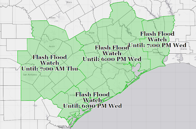
With all of this in mind, the National Weather Service has issued a FLASH FLOOD WATCH for the majority of south central Texas from Highway 281 east all the way to the coast and the Louisiana Border…various forecast offices issue different flash flood watches, therefore, the expiration times on all of these watches are different. For us here in central Texas the Flash Flood Watch is in effect from today through early Thursday morning…we are likely to begin feeling the impacts of this tropical disturbance, potentially tropical depression/storm Bill, here across south central Texas as early as tomorrow morning with potentially heavy tropical rain bands moving through the area…the weather service is calling for rainfall amounts of 2-4 inches across central Texas from Highway 281 east with localized amounts of 6-8 inches possible. 


Now, let’s look at forecast rainfall accumulation between now and Saturday morning on a state-wide level, the Weather Prediction Center is still focusing the heaviest of the rainfall to occur east of the Austin/San Antonio Metro Areas, however, with that being said, 2-4 inches with localized 6-8 inches is nothing to talk down, especially given our saturated ground…depending on the eventual track and strength of this system, there is the potential for some very serious flooding across portions of central Texas over the coming days…this is going to need to be monitored closely and it is up to each and every one of you to remain weather aware...please take all watches/warnings issued by the weather service seriously and remember, DO NOT ATTEMPT TO CROSS A FLOODED ROADWAY, REMEMBER, TURN AROUND, DON’T DROWN!!! 


Here’s a look at the latest computer model forecast guidance of where this system is likely to go…as you can see on the image below, a good majority of the models want to bring this system onto the middle Texas Coast (somewhere in between Houston and Corpus Christi) around midnight tonight…possibly later/earlier depending on the forward speed of this system. THE EVENTUAL TRACK OF THIS SYSTEM AND ITS STRENGTH ARE GOING TO BE CRUCIAL IN DETERMINING HOW MUCH RAINFALL WE SEE HERE IN CENTRAL TEXAS…IF THE BULK OF THE SYSTEM MOVES TO OUR EAST, WE WILL BE ON THE DRIER SIDE OF THE SYSTEM AND MAY NOT SEE AS MUCH RAIN, HOWEVER, IF THIS SYSTEM DECIDES TO MOVE DIRECTLY UP I-35 OR WORSE YET, WEST OF I-35, WE ARE MORE LIKELY TO RECEIVE SOME SERIOUS FLOODING ISSUES…THESE MODELS ARE NOT SET IN STONE AND ARE LIKELY TO CHANGE OVER THE COMING HOURS.