FORECAST
DISCUSSION:
Good
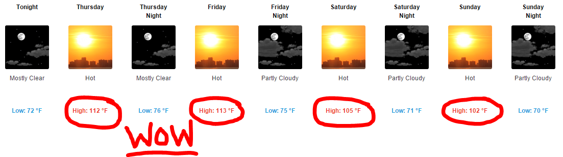
Wednesday afternoon everybody…I hope you all are doing well. Another typical
warm and muggy June day in progress across the area with temperatures in the
upper 80s and lower 90s…high dew points making it feel more like it’s in the
upper 90s to near 100°F…sea breeze moving up into the Austin Metro Area as of
4:53 pm CDT will likely kick off a tiny shower or two as it moves through the
metro area within the next hour…heaviest sea breeze activity is confined to our
southeast across Fayette County where a fairly heavy downpour with some
lightning and sub-severe gusty winds has developed. The rain chance at any one
location this evening is 20%, dropping below 10% after 7 pm as we begin to lose
the heat of day. Additional sea breeze showers and thundershowers possible
again on Thursday.
Radar
Snapshot (Wednesday, 4:49 pm CDT)…thin green line = sea breeze
boundary…yellows/reds = heavy downpours

Pattern
Shift
Pattern
shift sets up across the lower 48 as we head into the next couple of days with
a large ridge of high pressure setting up to our west and a deep trough of low
pressure setting up to our east. That upper level wind configuration will create
northerly winds aloft over Texas which will help to pull a rare June cool front
into the area on Saturday…the front will bring a SLIGHT,
did I mention slight, drop in temperature/humidity for the second half of the
weekend, but more importantly, this front will provide sufficient lift as it
moves into the area to generate some potentially heavy showers and
thunderstorms across the area during the day Saturday into early Sunday
morning. Storms that develop will have the potential to produce locally heavy
downpours, deadly cloud to ground lightning, and gusty winds. Right now, I’m
putting storm chances at 50% for Saturday and 30% for Sunday. The majority of
the storms that develop Sunday into early next week should be confined to areas
generally SOUTH of the Austin Metro Area as that is where the cool front will
stall out and ultimately fizzle.
Forecast
500 MB (18,500 feet above ground level) wind flow across North America early
Sunday morning…large ridge out west, deep trough out east…pink arrows = upper
level wind flow

Meteorologists pay very close attention
to upper level atmospheric dynamics because they ultimately create/steer
surface weather systems (pardon the advanced image below and focus on the big H
over the west, the big L over the great lakes and the pink arrows)
This
weather pattern will be bringing well above normal temperatures to the western
U.S. with below normal temperatures expected from the central into the eastern
U.S. (This image shows temperature forecast for June 30th through
July 4th)

Massive
ridge of high pressure will be bringing record-breaking heat to portions of
northern California and the Pacific Northwest…check out some of these forecasts
for select cities in those areas over the coming days (forecasts courtesy of
the National Weather Service)
Portland, OR

Medford, OR

Redding, CA
Forecast
Rainfall Accumulation/Lightning Safety
Pinpointing
how much rain we see across the area, I’m thinking a fairly scattered 0.25 to
0.50 inches of rain possible across much of the region with locally higher
totals exceeding an inch or two inches possible as the atmosphere will be
plenty juicy. We will have to be on the lookout for any slow-moving storms
along the front, as they may pose a flash flooding risk. Overall, I’m going to
be more concerned with folks outdoors and the potential for deadly lightning.
Remember, if you can hear thunder, go indoors…it does NOT have to be
cloudy or raining over your location for lightning to strike…it is a FACT
that lightning can strike some 5-20 miles away from a parent thunderstorm…those
bolts are commonly referred to as “bolts from the blue” and tend to produce the
majority of lightning fatalities.
“Bolt
from the Blue” Image: (Image Attached)

Photo
courtesy of Ace Flint Hills’ photographer Jim Saueressig II
No comments:
Post a Comment