Thursday, August 1, 2013

Saharan Dust

Saharan Dust heading to Texas? Believe it or not, it's possible! Matter of fact, it has already happened a couple of times this summer. Two days ago NASA's MODIS satellite photographed a massive dust storm pushing east off of the northwest coast of Africa with origins in the western Sahara Desert. Strong winds in that region this time of year frequently pick up large amounts of fine dust particles and strong easterly trade winds frequently carry that large cloud of dust and dry air across the Atlantic and into North America. This layer of dry, dusty air suppresses tropical storms and hurricanes from developing. Therefore, expect a quiet couple of weeks ahead in terms of tropical activity in the Atlantic. This massive cloud of dust and dry desert air is known as the SAL (Saharan Air Layer).

Massive Dust Storm moving off the coast of Africa (Image taken: July 30, 2013...MODIS)


Incredible animation of the dusty dry air moving across the Atlantic. The yellows, reds, and pinks indicate that dry dusty air. It is amazing to see just how much dust is crossing the Atlantic and at how fast it is traveling.


Information below was taken from Dr. Jeff Masters' WunderBlog
 
How dust affects hurricanes
Saharan dust can affect hurricane activity in several ways:

1) Dust acts as a shield which keeps sunlight from reaching the surface. Thus, large amounts of dust can keep the sea surface temperatures up to 1°C cooler than average in the hurricane Main Development Region (MDR) from the coast of Africa to the Caribbean, providing hurricanes with less energy to form and grow. Ocean temperatures in the MDR are currently 0.7°F above average, and this anomaly should cool this week as the dust blocks sunlight.

2) The Saharan Air Layer (SAL) is a layer of dry, dusty Saharan air that rides up over the low-level moist air over the tropical Atlantic. At the boundary between the SAL and low-level moist air where the trade winds blow is the trade wind inversion--a region of the atmosphere where the temperature increases with height. Since atmospheric temperature normally decreases with height, this "inversion" acts to but the brakes on any thunderstorms that try to punch through it. This happens because the air in a thunderstorm's updraft suddenly encounters a region where the updraft air is cooler and less buoyant than the surrounding air, and thus will not be able to keep moving upward. The dust in the SAL absorbs solar radiation, which heats the air in the trade wind inversion. This makes the inversion stronger, which inhibits the thunderstorms that power a hurricane.

3) Dust may also act to produce more clouds, but this effect needs much more study. If the dust particles are of the right size to serve as "condensation nuclei"--centers around which raindrops can form and grow--the dust can act to make more clouds. Thus, dust could potentially aid in the formation and intensification of hurricanes. However, if the dust acts to make more low-level clouds over the tropical Atlantic, this will reduce the amount of sunlight reaching the ocean, cooling the sea surface temperatures and discouraging hurricane formation (Kaufman et al., 2005.)


Incredible forecast model showing where the dust layer should be over the coming days provided by NOAA's Visualization Laboratory using the NOAA NGAC Aerosol Model. Some of that dust is likely to make it to Texas sometime next week! When that happens our skies turn a milky, hazy color instead of blue and sunsets take on a characteristic red glow. Of course, the dust in the air will put air quality levels in the moderate category. Therefore, those that are sensitive to dust and allergens will need to limit time spent outdoors or just avoid outdoor activity altogether. 

 http://www.youtube.com/watch?v=F3Q8Sh2AjPo

As for our weather here in central Texas over the next 7-10 days, expect more of the same. With high pressure directly overhead air is forced to sink. When air sinks it compresses and heats up. That sinking air combined with our dry ground is the perfect combination to give us day after day after day of triple digit heat. You can think of high pressure as a big shield over Texas keeping rain out.


New drought report just put out today shows that 97% of the state of Texas is in drought. Unfortunately new forecasts out today also show our drought persisting into the fall.


HEAT RELIEF?
 
Don't get excited yet, because it is August and it is a long way's out, however, long range forecast models are showing a cool front pushing into Texas late next week or next weekend that may help to push highs back into the lower to middle 90s for a couple of days. However, because of that front we may see extremely HOT temps in the 104-108°F range by the time we get into the middle to end of next week ahead of the front. 


Monday, July 15, 2013

RAIN, RAIN, RAIN

It is not often that I get to write that glorious "r-word," RAIN, in the middle of July. Here I am at 11:25 a.m. in the morning and it is only 73°F here in Austin...we are normally in the upper 80s and lower 90s across the area at this time. 

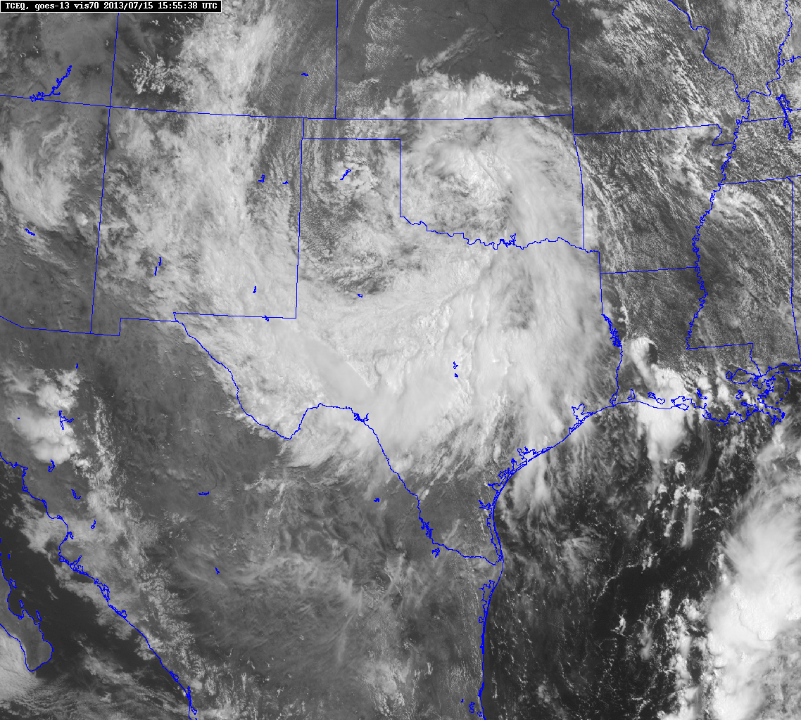
So, what's causing this cloudy and showery weather during the middle of July? Well, it's not out of the tropics like one would expect this time of year, however, it is thanks to a strange tracking area of upper level low pressure that was located across the Mid-Atlantic states last week. Remember that BIG ridge of high pressure that gave us 104°F on Friday and 105°F on Saturday? Well, that ridge of high pressure has pushed west and allowed for a large area of low pressure to be pulled into the southern plains. Remember, low pressure causes air to rise...rising air in turn produces clouds which in turn produces showers and thunderstorms. High pressure does the exact opposite. The clouds and rain will help to keep temperatures below average for the next couple of days.

Low's Track: 


 Upper Level Low clearly evident on water vapor imagery (distinct counter-clockwise rotation):


Latest Visible Satellite Imagery over Texas:


Latest Doppler Radar Loop: More heavy downpour popping along the I-35 corridor and another large area of heavy showers approaching from the west...A LOT MORE RAIN is on the way! Enjoy! 


If you haven't received any rain yet, don't give up. We have decent rain chances through Thursday. Some spots, such as Burnet, have already picked up over 6 inches of rain!!! This area of low pressure will continue to slowly push west over the next several days where it is likely to fall apart over the desert southwest. 

Latest high resolution forecast models say as much as 6 inches of additional rainfall could fall in spots across central Texas with some folks only picking up a half of an inch of rainfall through Wednesday evening.

Forecast Radar Monday Evening:


Projected Rainfall Totals through Wednesday Evening:


Friday, June 28, 2013

RECORD HEAT


Well folks, we officially did it. We climbed to 106°F this afternoon at Austin’s Camp Mabry which beat the previous record high for this date of 104°F set all the way back in the hot summer of 1923. Austin Bergstrom International Airport also set a brand new record high of 105°F this afternoon beating their previous record high of 103°F set back in 1956. Strong ridge of high pressure centered across the four corners region is allowing for strong subsidence (sinking air) across the state of Texas, hence, the lack of cloud coverage across the region the past couple of days. Sinking air compresses and heats up rapidly. With plenty of sun and relatively dry ground, temps were able to skyrocket today. Add to that combination an approaching frontal boundary, which actually makes conditions even HOTTER ahead of it thanks to additional compression.

Check out this giant ridge of high pressure (that is one big mountain of hot air)-

 I just finished scanning all of the latest computer models and they are indicating that Saturday has the potential to be even HOTTER than today. The record high on Saturday for Austin is 105°F set back in the very hot summer of 2009. Some forecast models want to push highs to near 110°F across the region for Saturday. While models may be over estimating a bit, I’m still thinking temperatures will likely range anywhere from 103-107°F across central Texas on Saturday. The only difference on Saturday is that moisture levels may begin to creep up a bit more in the mid-levels of the atmosphere above central Texas which could aid a few spotty, but STRONG storms to form across the area. These storms would be capable of very strong, damaging winds given the extreme heat.

High Resolution NAM Forecast Model for Saturday (Forecast High Temps)- 


As “cooler” air begins to filter into the region early Sunday morning, highs are likely to stay below 100°F with a chance for showers and storms. With high pressure pushing farther off to the west and a trough of low pressure setting up across Texas, northwesterly winds in the upper levels of the atmosphere would help to carry disturbances (areas of lift/complexes of showers and storms) out of eastern New Mexico into central Texas. At least one of the forecast models shows a cluster of storms moving into central Texas Sunday evening.

Forecast Radar Sunday afternoon/evening:

If it makes you feel any better we are not the only ones suffering through extreme heat, temperatures are approaching 120°F across the Phoenix Metro Area this afternoon with temps nearing 130°F expected across Death Valley, CA…In fact, even the Pacific Northwest is heating up in the 80s. Portland, Oregon may hit 100°F by early next week with Seattle close behind in the 90s. Overall, once we get past Saturday conditions look to cool down here in central Texas with at least slight rainfall chances coming into the picture. Of course you can always get the latest weather information on my Facebook page, Michael’s Weather Center. 

National Temps as of this afternoon: Anywhere shaded in white is above 100°F...anywhere shaded in purple is above 90°F! Anywhere shaded in gray is above 110°F!!!


Tuesday, May 28, 2013

FLASH FLOOD WATCH

Good Afternoon everybody! As of 4 p.m. we are currently sitting at 90°F here in Austin under a partly cloudy sky. The National Weather Service has just issued a FLASH FLOOD WATCH for much of central Texas, including, but not limited to: Burnet, Blanco, Williamson, Travis, Hays, Comal, Bexar, Bastrop, Caldwell, Lee, and Fayette counties. The FLASH FLOOD WATCH will go into effect at 7 a.m. Wednesday morning and continue through 7 p.m. Wednesday evening. All the counties shaded in dark green are under the FLASH FLOOD WATCH on Wednesday. This is not a sure thing right now, however, IF storms are able to develop they could dump anywhere from 1-3 inches of rain across central Texas on Wednesday.


Here's the Set-Up:

A trough of low pressure (a dip in the jet stream/elongated area of lower atmospheric pressure) will be approaching Texas and much of the central plains from the west...as this trough of low pressure approaches air is forced to rise ahead of it. As warm, humid air rises into cooler air aloft it will condense and in turn precipitate. The jet (river of fast moving air) flowing around trough carries disturbances (areas of lift) within it...those areas of lift help to further enhance shower and thunderstorm activity.


The National Weather Service posted this along with the FLASH FLOOD WATCH: An upper level disturbance is expected to force thunderstorms developing over the mountains of northern Mexico and west Texas right now east towards far western portions of central Texas this evening. That complex of storms will continue to march east into the Texas Hill Country and finally into the I-35 corridor during the day on Wednesday. The complex of storms that is forecast to develop is known as an MCS (Mesoscale Convective System). Once this MCS develops it will have plenty of deep Gulf moisture to allow for it to continue to move east into central Texas. While the risk of large hail and destructive winds looks to be low for Wednesday, the biggest threat from the storms will be torrential downpours that could lead to flooding. Already saturated ground will result in rapid runoff. We picked up between 3-4 inches of rain here in Austin last Friday and Saturday with the San Antonio Metro Area picking up over 12 inches of rain last Friday and Saturday. In fact, San Antonio recorded their second wettest day EVER on Saturday with 9.87 inches of rainfall! Most models are not forecasting a major rainfall event, however, it is possible! The models did not forecast last week's rains either!


Highs across the area should be held down in the 80s thanks to the added cloud cover and the chance for storms. However, the humidity levels will be quite high making it feel rather sticky. Lows tonight will only fall into the lower 70s.

This same trough of low pressure that MAY bring us storms here in central Texas will be wreaking havoc across the central Plains where they will be under a MODERATE RISK for severe weather: large hail, large tornadoes, and destructive winds all likely in the areas shaded in red! Much of western Oklahoma and central Kansas is under the MODERATE RISK.


Monday, May 20, 2013

Severe Weather Threat Increasing Tomorrow

Good Afternoon everybody! As of 2 p.m. we are up to 92°F here in Austin with plenty of haze and humidity in the air as well. Breezy, moist southerly winds off of the Gulf of Mexico will be fueling large tornadic thunderstorms across Oklahoma, extreme north Texas, northwestern Arkansas, and southern Missouri later this afternoon. Taking a look a the latest visible satellite imagery, storms are already beginning to fire along a stationary frontal boundary across Oklahoma and extreme north Texas. In fact, the Storm Prediction Center is currently monitoring areas from the Red River south into extreme northern portions of central Texas for the issuance of a possible SEVERE STORM WATCH or TORNADO WATCH within the coming hours. 

Intense heat and moisture combined with a slow moving southward moving frontal boundary will increase our chances for severe storms here in Central Texas for Tuesday. The main threats from the storms that develop Tuesday afternoon will be very large hail, damaging winds, and isolated tornadoes. The greatest tornado threat on Tuesday looks to be across northeastern portions of Texas, however, a tornado can never be ruled out when severe thunderstorms are in the forecast. The chance for storms tomorrow is at 50-60% for central Texas. Highs will climb well into the 90s Tuesday afternoon and that intense heat combined with lift produced from the boundary will work together to allow for explosive thunderstorm development. The Storm Prediction Center says there is at least a 30% chance for every storm that develops to produce some sort of severe weather. Hail up to the size of baseballs is not out of the question!

Storm Prediction Center's Outlook for Tuesday:


Storm Prediction Center's Probabilistic Outlook for Tuesday:


Future Simulated Radar for Texas tomorrow evening...strong/severe storms will be stretching from northeast Texas all the way back down into central Texas:


The atmosphere will be extremely unstable across much of Texas tomorrow as evidenced by EXTREMELY HIGH cape values...cape is a measure of how quickly the air is rising...the higher the cape the worse the storm...CAPE VALUES will be anywhere from 3000 to 5000 joules/kilogram across the state tomorrow:


By the way, if you are wondering why it has been so hazy lately it is due to the large agricultural fires burning across Mexico...farmers burn sugar cane this time of year in southern Mexico and strong southerly winds carry that smoke into Texas. 

Tuesday, May 14, 2013

More storms on the way!

Hello everybody! I hope you all had a wonderful weekend and got a chance to enjoy the beautiful weather. As for today (Tuesday) skies will remain mostly sunny to partly cloudy and temps will be quite warm in the middle to upper 80s across the area. Southerly winds have returned to the area and have allowed for low-level Gulf of Mexico moisture to return to the area; as evidenced by dew points climbing into the 50s and 60s today as compared to numbers in the 40s yesterday. 


 The Storm Prediction Center out of Norman, Oklahoma has placed southern portions of west Texas (from San Angelo to Del Rio) under the SLIGHT RISK CATEGORY for severe weather. This slight risk area does include the extreme western Hill Country as well. Latest high resolution forecast models show a strong disturbance moving out of northern Mexico later this afternoon/evening will produce enough lift to generate strong/severe storms across southwestern Texas...those storms will be capable of producing very large hail and damaging winds in excess of 60 mph. An isolated tornado can never be ruled out during a severe thunderstorm event.


 So, why should we care what's going on in west Texas? Well, those storms that develop across northern Mexico and Del Rio, Texas later this afternoon will organize into a line of storms and push east towards central Texas late tonight and into the early morning hours of Wednesday. If the storms are able to hold together, they will have the potential to bring strong gusty winds, heavy rainfall, small hail, and plenty of lightning to the area overnight.  The chance for storms tonight is 60% across the Hill Country, 50% along the I-35 corridor, and 40% for areas east of I-35.

One high resolution model I look at brings a solid line of storms into central Texas between midnight and 2 a.m.


 Another high resolution model I look at brings a line of storms into central Texas early Wednesday morning between 4-8 a.m.


 Once the possible storms blow through early Wednesday, skies will clear and temps will soar back into the 80s (the atmosphere will recharge itself)...the warmer we get, the more unstable conditions will become. The high resolution NAM model is forecasting very high CAPE values to return to central Texas Wednesday afternoon/evening (especially across the Hill Country). CAPE values may exceed 4000 joules per kilogram over the Hill Country which means storms that develop will quickly become severe with large hail and damaging winds. The higher the CAPE the more unstable the atmosphere (meaning that air will be rising very quickly and forcefully into the atmosphere aloft)...remember, you need lots of rising air to get storms.


 As that disturbance moves from northern Mexico into north central Texas tomorrow a line of storms should develop west of the DFW Metroplex across the Interstate 20 corridor...upper level winds will push those storms towards central Texas late Wednesday afternoon/evening. Individual storms that are able to develop tomorrow afternoon across central Texas will have to be monitored closely for the possibility of very large hail and damaging winds. The chance for rain Wednesday is at least 50%.


 Models are indicating a widespread 0.50 inches of rainfall could fall between tonight and Wednesday night across the area...of course, some areas may receive as much as 1.50 inches of rainfall if caught under a heavy downpour.


Wednesday, May 8, 2013

Severe Weather on the Way!

Hello everybody! I hope you are all doing well. I know it has been a while since I last posted. Well, moisture levels have really come up across the area from just 24 hours ago thanks to a southerly surface wind flow off of the Gulf of Mexico...those breezy southerly winds will persist through Friday ahead of our next strong storm system and frontal boundary that will work together to bring us a very good chance for thunderstorms on Friday. 

The Storm Prediction Center in Norman, Oklahoma has placed central Texas under the SLIGHT RISK CATEGORY for severe thunderstorms capable of producing large hail, damaging winds, and isolated tornadoes on Thursday and Friday. Honestly, I think areas north and west of Austin will have the greatest risk for severe weather on Thursday, however, severe storms will still be a possibility in Austin. The greater risk for severe weather comes on Friday as a Pacific Frontal Boundary attached to a low pressure system clashes with the warm, humid air over central Texas.

Forecast Radar for Friday Evening: Storms develop in Hill Country and push east towards Austin!


Thursday's Severe Weather Risk Area: 


Friday's Severe Weather Risk Area:


Besides the threats for large hail, damaging winds, and isolated tornadoes, latest computer models continue to indicate a good soaking for much of central Texas with the storms that are expected to arrive late Thursday and persist through Saturday. Of course the storms will come in waves, it is not going to be storming for 48 hours straight. Highs will continue in the 80s through the next seven days with lows in the 60s!

GFS Forecast Rainfall Accumulation: 0.50-1.50 inches


NAM Forecast Rainfall Accumulation: 1-2 inches


Weather Prediction Center's Forecast Rainfall Accumulation: 1-2 inches


Mother's Day Forecast: As of now, Mother's Day looks to be partly sunny and warm with highs in the lower 80s. Rain will have moved well east of central Texas by then. Overall, looks to be a nice day.