Hello everybody! I hope you all had a wonderful weekend and got a chance to enjoy the beautiful weather. As for today (Tuesday) skies will remain mostly sunny to partly cloudy and temps will be quite warm in the middle to upper 80s across the area. Southerly winds have returned to the area and have allowed for low-level Gulf of Mexico moisture to return to the area; as evidenced by dew points climbing into the 50s and 60s today as compared to numbers in the 40s yesterday.
The Storm Prediction Center out of Norman, Oklahoma has placed southern portions of west Texas (from San Angelo to Del Rio) under the SLIGHT RISK CATEGORY for severe weather. This slight risk area does include the extreme western Hill Country as well. Latest high resolution forecast models show a strong disturbance moving out of northern Mexico later this afternoon/evening will produce enough lift to generate strong/severe storms across southwestern Texas...those storms will be capable of producing very large hail and damaging winds in excess of 60 mph. An isolated tornado can never be ruled out during a severe thunderstorm event.
So, why should we care what's going on in west Texas? Well, those storms that develop across northern Mexico and Del Rio, Texas later this afternoon will organize into a line of storms and push east towards central Texas late tonight and into the early morning hours of Wednesday. If the storms are able to hold together, they will have the potential to bring strong gusty winds, heavy rainfall, small hail, and plenty of lightning to the area overnight. The chance for storms tonight is 60% across the Hill Country, 50% along the I-35 corridor, and 40% for areas east of I-35.
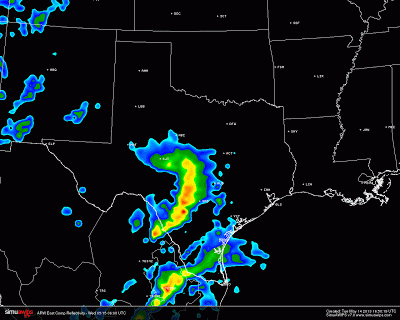
One high resolution model I look at brings a solid line of storms into central Texas between midnight and 2 a.m.
Another high resolution model I look at brings a line of storms into central Texas early Wednesday morning between 4-8 a.m.
Once the possible storms blow through early Wednesday, skies will clear and temps will soar back into the 80s (the atmosphere will recharge itself)...the warmer we get, the more unstable conditions will become. The high resolution NAM model is forecasting very high CAPE values to return to central Texas Wednesday afternoon/evening (especially across the Hill Country). CAPE values may exceed 4000 joules per kilogram over the Hill Country which means storms that develop will quickly become severe with large hail and damaging winds. The higher the CAPE the more unstable the atmosphere (meaning that air will be rising very quickly and forcefully into the atmosphere aloft)...remember, you need lots of rising air to get storms.
As that disturbance moves from northern Mexico into north central Texas tomorrow a line of storms should develop west of the DFW Metroplex across the Interstate 20 corridor...upper level winds will push those storms towards central Texas late Wednesday afternoon/evening. Individual storms that are able to develop tomorrow afternoon across central Texas will have to be monitored closely for the possibility of very large hail and damaging winds. The chance for rain Wednesday is at least 50%.
Models are indicating a widespread 0.50 inches of rainfall could fall between tonight and Wednesday night across the area...of course, some areas may receive as much as 1.50 inches of rainfall if caught under a heavy downpour.


No comments:
Post a Comment