Good Afternoon everybody! As of 4 p.m. we are currently sitting at 90°F here in Austin under a partly cloudy sky. The National Weather Service has just issued a FLASH FLOOD WATCH for much of central Texas, including, but not limited to: Burnet, Blanco, Williamson, Travis, Hays, Comal, Bexar, Bastrop, Caldwell, Lee, and Fayette counties. The FLASH FLOOD WATCH will go into effect at 7 a.m. Wednesday morning and continue through 7 p.m. Wednesday evening. All the counties shaded in dark green are under the FLASH FLOOD WATCH on Wednesday. This is not a sure thing right now, however, IF storms are able to develop they could dump anywhere from 1-3 inches of rain across central Texas on Wednesday.
Here's the Set-Up:
A trough of low pressure (a dip in the jet stream/elongated area of lower atmospheric pressure) will be approaching Texas and much of the central plains from the west...as this trough of low pressure approaches air is forced to rise ahead of it. As warm, humid air rises into cooler air aloft it will condense and in turn precipitate. The jet (river of fast moving air) flowing around trough carries disturbances (areas of lift) within it...those areas of lift help to further enhance shower and thunderstorm activity.
The National Weather Service posted this along with the FLASH FLOOD WATCH: An upper level disturbance is expected to force thunderstorms developing over the mountains of northern Mexico and west Texas right now east towards far western portions of central Texas this evening. That complex of storms will continue to march east into the Texas Hill Country and finally into the I-35 corridor during the day on Wednesday. The complex of storms that is forecast to develop is known as an MCS (Mesoscale Convective System). Once this MCS develops it will have plenty of deep Gulf moisture to allow for it to continue to move east into central Texas. While the risk of large hail and destructive winds looks to be low for Wednesday, the biggest threat from the storms will be torrential downpours that could lead to flooding. Already saturated ground will result in rapid runoff. We picked up between 3-4 inches of rain here in Austin last Friday and Saturday with the San Antonio Metro Area picking up over 12 inches of rain last Friday and Saturday. In fact, San Antonio recorded their second wettest day EVER on Saturday with 9.87 inches of rainfall! Most models are not forecasting a major rainfall event, however, it is possible! The models did not forecast last week's rains either!
Highs across the area should be held down in the 80s thanks to the added cloud cover and the chance for storms. However, the humidity levels will be quite high making it feel rather sticky. Lows tonight will only fall into the lower 70s.
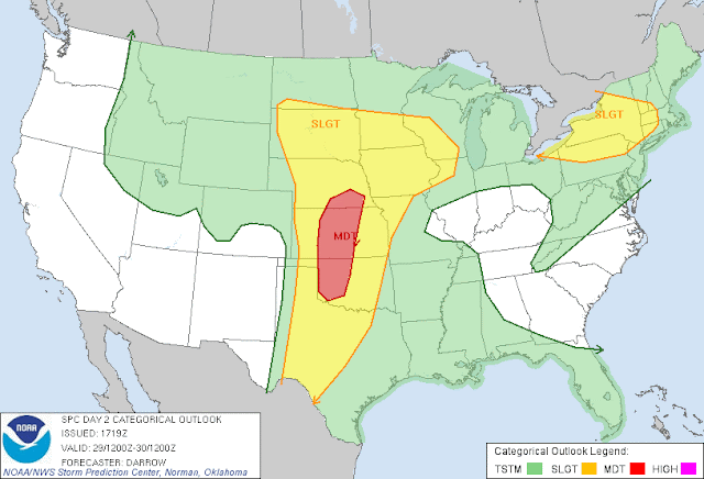
This same trough of low pressure that MAY bring us storms here in central Texas will be wreaking havoc across the central Plains where they will be under a MODERATE RISK for severe weather: large hail, large tornadoes, and destructive winds all likely in the areas shaded in red! Much of western Oklahoma and central Kansas is under the MODERATE RISK.


No comments:
Post a Comment