Friday, February 21, 2014

Winter is NOT over yet!

TGIF Everybody! I hope you are all having a wonderful day. The weather is absolutely fantastic today behind yesterday's cool front. Currently sitting in the 60s across all of central Texas under a mostly sunny sky.

Temperature Anomaly for next Wednesday. This map shows departure from normal "average" temperature for the United States. This forecast model is forecasting temps to be some 20 to 30 degrees below normal across Texas next Wednesday. Normal highs for this time of year are in the middle to upper 60s. As you can see, much of the U.S. will be shivering again by the middle to end of next week. 


Strong westerly winds aloft (around 18,000 feet above us) will ensure a warm and quiet weather pattern as well as a warming trend. After a cool night tonight with lows dipping into the upper 40s southerly winds will really help to increase both the humidity and the temperature as we get into the weekend. Highs Saturday expected to be in the upper 70s to near 80°F area wide under a partly sunny sky. Thanks to those southerly winds, widespread clouds and patchy areas of drizzle will move in late Saturday and persist through Sunday morning before clouds break up Saturday afternoon and push highs into the lower 80s across the area. A brief cool down is possible on Monday behind a weak cool front, however, highs are still likely to be in the 70s. Highs climb well into the 70s and 80s across much of central and south Texas on Tuesday ahead of an Arctic Cold Front that will blast through the area late Tuesday night/early Wednesday morning. We will wake up to temperatures in the mid and upper 30s next Wednesday with highs struggling to make the mid 40s on a gusty north wind. Latest forecast model guidance suggests some very light rain is possible behind the front on Wednesday as warm, moist air is forced to ride up and over the cold, dense Arctic Air at the surface. This pattern is called overrunning. It is not out of the question to see some sleet pellets mixed in with the light rain Wednesday afternoon. Keep in mind, this is a way's out and the forecast is likely to change several times in the coming days. 

Widespread freeze is beginning to look likely early Thursday morning before highs briefly rebound into the 50s Thursday afternoon. Increasing clouds and a chance for rain next Friday will likely keep highs in the 40s with lows in the 30s (we should remain above freezing during this time).

Deep blue represents areas at or below freezing next Thursday morning:


Very cold will build across northwest Canada and Alaska over the coming days and that air will push south and drop temperatures well below average across much of the lower 48. The pink and white temperature shading represents frigid Arctic Air. Extreme bright white represents temperatures about 30 degrees BELOW ZERO!


Saturday, January 25, 2014

Roller Coaster Weather

Hello everybody! I hope you are all having a great weekend. I apologize as I realize it has been quite a while since I have posted, however, you can always stay up to date with the forecast on my Facebook Page, Michael's Weather Center. Just click on the name of my page and you will be able to directly access it. You don't need to have a Facebook account to view the page.

Okay, let's get right to it as there is quite a bit to talk about over the next several days. After an icy and cold day yesterday with temperatures in the 30s to 40 degrees across the area we managed to climb to 70ºF Saturday afternoon at Camp Mabry which is 8 degrees ABOVE NORMAL for this time of year. We are going to be closer to 15 degrees above normal on Sunday with warm, breezy, southwesterly winds ahead of a powerful Arctic Front that will blast through the area early Monday morning and quickly put an end to our spring-like weather on Sunday. Latest forecast models push all of central Texas into the 70s Sunday afternoon. We should top out in the middle 70s here in Austin, however, some spots may climb into the upper 70s (especially south and west of Austin) where areas along the Texas-Mexico Border will likely climb into the lower 80s! Southwesterly winds are forced to sink and compress as they drop in elevation off of the Mexican Plateau. When air is compressed it warms up. With that being mentioned, get ready for a sunny, warm, spring-like day on Sunday.

FORECAST HIGHS SUNDAY (4km NAM MODEL):
Winds: SW at 10-20 mph


Old Man Winter will quickly put an end to spring by Monday morning with the arrival of a powerful Arctic Cold Front that will really kick up the winds across the area. Especially for areas along and east of the Balcones Escarpment (basically along and east of the I-35 corridor). The National Weather Service has already mentioned that they are likely to issue a WIND ADVISORY for much of the area on Monday as north winds will be sustained at 20-30 mph for a good portion of the morning and afternoon hours with gusts in the 35-40 mph range likely.

FORECAST SUSTAINED WIND SPEEDS 
TUESDAY MORNING (4KM NAM MODEL)


Latest forecast models show the Arctic Front pushing through the area before daybreak Monday. Temperatures look to hold steady in the 40s for much of the day Monday before plummeting into the 30s by late afternoon and then finally into the 20s late Monday into early Tuesday morning.

FORECAST LOWS TUESDAY MORNING ACROSS THE SOUTH
4 KM NAM MODEL  


Just as temperatures drop below freezing late Monday night a cut-off low (disturbance) will be moving towards Texas out of northern Mexico.

FORECAST POSITION OF CUT-OFF LOW
LATE MONDAY/EARLY TUESAY: (4KM NAM MODEL)


That disturbance will help to provide lift in the atmosphere and will cause light showers to develop across the region (especially for Austin and areas south). Gulf Moisture will be lifted up and over the cold, dense Arctic Air at the surface and create cloudy skies across the area. With temperatures below freezing at the surface, those showers will likely come down in the form of freezing rain, sleet, and possibly snow). This is not a sure thing at this point in time, however, it bears watching as the morning commute on Tuesday morning could potentially be a slippery one if the precipitation comes down as freezing rain instead of snow.

FORECAST PRECIP. TYPE EARLY TUESDAY MORNING
4km NAM MODEL SHOWING SLEET & SNOW MIX FALLING ACROSS THE AREA
SALMON COLOR = SLEET
BLUE = SNOW
GREEN = RAIN/POSSIBLE FREEZING RAIN


Highs will STRUGGLE to hit 40ºF Tuesday afternoon with wind chills expected to be in the 20s for the majority of the day. Wind chills late Monday night and early Tuesday morning will easily drop into the TEENS! Hard freeze likely across the region by early Wednesday morning with all locations dropping into the low and middle 20s. Some low-lying locations may drop into the upper teens. Skies clear out for Wednesday, however, things will remain chilly with highs only expected to make the middle 40s, however, the sunshine will help to make it feel better. 

***THANKS FOR READING MY BLOG***


Thursday, December 19, 2013

Stormy Saturday

Hello everybody. Strong southerly winds today were feeding a surface area of low pressure across Colorado and the Texas Panhandle. Winds gusted as high as 35 mph here in the city at Camp Mabry and 37 mph along the runways at Austin Bergstrom International Airport. Highs today climbed well into the middle and upper 70s across central Texas. We were running some 14-16 degrees above normal.

I'm monitoring a strong upper level low pressure system across southern California right now that will quickly approach Texas during the day on Friday and pass overhead by Saturday. Ahead of the area of low pressure Gulf of Mexico moisture will continue to pour into Texas on breezy/gusty southerly winds. As that storm system and its attendant frontal boundary approach the area I'm expecting showers and thunderstorms to develop as early as Saturday morning and persist through Saturday morning before skies rapidly clear on gusty northerly winds as much drier and cooler air infiltrates the region.

Upper Level Storm System:

 
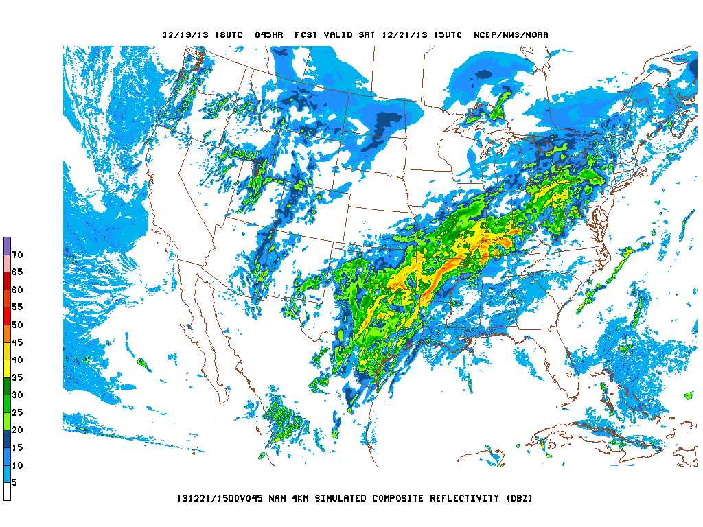
Forecast Radar across the U.S. on Saturday:

The Storm Prediction Center has placed areas along and east of I-35 under the SLIGHT RISK CATEGORY for severe weather. The main threats from the storms that develop will be strong winds, hail, brief heavy rainfall, and cloud to ground lightning. Rainfall totals will likely be less than an inch across the area. The greatest threat for severe weather with this system will be east of Austin.

Severe Weather Risk Map:


Cool, dry air will filter into the state behind the storm system and set us up for a windy, sunny, and much cooler Sunday with highs in the 50s. Lows will drop into the 30s area wide Sunday night and highs will top out in the 50s on Monday under a sunny sky. Light freezes possible Monday and Tuesday nights. Christmas Day looks mostly sunny and cool with a high in the lower 60s.

Forecast Highs across the U.S. on Christmas Day:


Sunday, December 1, 2013

WARM then COLD!!!

Hello everybody. I hope you all enjoyed a wonderful Thanksgiving with friends and family. Temperatures have managed to warm back into the 70s across a good portion of central Texas this afternoon thanks to southwesterly winds at the surface. Temperatures will only continue to climb as we get into Monday and Tuesday ahead of a series of cold fronts that will be heading our way. 

After a cool start in the 50s Monday morning highs will easily climb into the upper 70s to lower 80s across the area thanks to warm westerly winds blowing down to the surface. That scenario will repeat itself again on Tuesday, except it may even get warmer with highs in the lower 80s being more common.  An increase in clouds and moisture will keep highs in the lower 70s Wednesday afternoon ahead of the first in a series of cold fronts that will arrive late Wednesday night and drop highs on Thursday into the 50s.

A look at what the GFS Model believes temperatures will look like Thursday afternoon:


Thursday night a second stronger push of Arctic Air will drop temps into the 30s and 40s Thursday night with highs staying in the 40s all day Friday before plummeting even farther late Friday afternoon as the main surge of Arctic Air infiltrates the region. This surge of Arctic Air will send temperatures into the 20s and lower 30s by Saturday Morning with wind chills easily falling into the teens!!!

Forecast Temperatures Saturday Morning:


Highs on Saturday and Sunday will likely stay in the 30s with wind chills in the 20s; lows will drop below the freezing mark both Saturday and Sunday nights under a cloudy sky. This is where things could get tricky. There is a chance for wintry precipitation beginning as early as Friday night and persisting through the weekend. If temperatures at the surface are at 32°F or colder rain falling would turn into freezing rain. The chance for precipitation over the weekend is at 30-40%.

Wintry Precipitation (Freezing Rain/Sleet) Possible as early as Friday Evening according to the GFS Model:


The ECMWF Model has the cold air holding off until late Thursday. It is forecasting a cold weekend as well with temps in the 30s and 40s with freezes at night, however, the ECMWF shows a quick warm up into the 50s and 60s on Monday ahead of what would be a second, even stronger front that would arrive late Monday (of next week) and send temperatures into the 30s for highs Tuesday and Wednesday of next week with lows in the 20s!!!

***Keep in mind this forecast is subject to change and specifics still need to be worked out. Get ready for some much colder weather after a brief warmup early this week***

Monday, November 18, 2013

COLD WEATHER is on the way!

It is hard to think about cold weather after yesterday's record breaking heat at both Camp Mabry and Austin Bergstrom. We officially topped out at 90°F at Camp Mabry which is actually 19 degrees above normal for this time of year. The old record was 86°F set back in 1938.

The majority of this week looks to be rather mild with slight rain chances entering the forecast as soon as Wednesday as southerly flow off of the Gulf of Mexico increases ahead of our next strong cold front that looks to arrive Friday afternoon. The "coolest" day between now and Friday looks to be Tuesday with many locations topping out in the upper 60s and lower 70s. Temperatures will start off in the 50s both Tuesday and Wednesday mornings before climbing into the 60s for Thursday and Friday mornings. Afternoon highs on Thursday will approach the 80 degree mark in spots. 

Check out the FRIGID Air north of the Canadian Border waiting to pour south into the lower 48: Temperatures are well below zero across a large portion of the Canada and Alaska. The coldest temperature I could find was -35°F in the Yukon Territory.


The ECMWF (European Forecast Model) wants to bring the Arctic Front into central Texas around 6 p.m. Friday evening. A line of fast moving showers and thunderstorms would be possible along the front. Behind the front temperatures would rapidly fall from the 70s into the 40s on a powerful north wind. This particular model has us waking up to temps in the 30s area wide with wind chills in the 20s on Saturday morning. Areas north and west may receive a freeze. Highs on Saturday would struggle to get out of the 40s. Lows would fall back into the lower to middle 30s Saturday night with highs struggling back into the 40s on Sunday.


The GFS (American Forecast Model) wants to bring the Arctic Front into central Texas closer late Friday evening into the early morning hours of Saturday. The GFS is forecasting temps to stay in the 40s all day Saturday with lows falling to near freezing across all of central Texas Saturday night. Highs on Sunday would struggle to get into the 40s under a cloudy sky. This cold air will push well south into Mexico.


Too early to say if wintry precipitation is going to be an issue for us here in Central Texas. Portions of north and west Texas may receive some snow. However, as of right now it does not look likely. What looks more likely is a cold rain to develop behind the front. The GFS Model is showing temperatures to be well above freezing by the time the rain would start falling. It is definitely something to keep an eye on. Of course this forecast is subject to change over the next several days.

Between now and next Monday the Weather Prediction Center is forecasting a good 1-1.5 inches of rain to fall in Central Texas: We will take it!!


***Just know that significantly colder weather is due to arrive this weekend***

Wednesday, October 30, 2013

Thunderstorms on the way!

Good Afternoon Everybody! I just wanted to take a moment to write a brief blog on the heavy rainfall event that is likely to take shape this evening and through the overnight hours.

All the ingredients are coming together for rounds of heavy showers and thunderstorms to move through the region beginning this evening and persisting through Thursday morning. Plenty of Gulf of Mexico moisture, combined with upper level moisture from Tropical Storm Raymond out in the Pacific and an approaching storm system and its attendant cold front will all work together to give us a 100% chance for storms beginning this evening and persisting through Thursday morning. The heaviest activity, according to the latest run of the HRRR Model (High Resolution Rapid Refresh Model) will arrive around, if not before, midnight for the far western Hill Country. The model is showing a strong, possibly severe, line of storms pushing into the region. Storms that develop will have the potential to produce strong damaging winds and hail. That line of storms will move from west to east through the overnight hours and looks to arrive along the I-35 corridor around 3 a.m. Keep in mind, things may slow down or speed up. 

Forecasted Radar for 1 a.m. (Strong, possibly severe, line of storms pushing through the Hill Country):


Given our risk for severe weather, the Storm Prediction Center has placed much of north, central, east, and south Texas under the SLIGHT RISK category for severe weather this evening and overnight. Areas shaded in yellow are under the Slight Risk Category.


In addition, and of even greater concern, is the risk of flash flooding. The tropical air mass in place will assure that the storms will drop copious amounts of rainfall quickly. I'm expecting a good 1-3 inches of rain to fall area wide with some spots picking up as much as 4-5 inches of rain. 

The good news is that once the line of storms pushes through a clearing trend will take place for Thursday (Halloween) afternoon. Cooler and drier weather will arrive behind the front by Friday morning with lows expected to fall into the 40s and 50s. Beautiful weekend shaping up with highs in the 70s and 80s and lows in the 40s and 50s. Saturday night looks to be the coldest night under clear skies; mid 40s expected here in Austin. Out-lying areas will dip into the lower 40s. Clouds increase on Sunday ahead of our next storm system that will bring rain chances back to central Texas for the beginning of next week ahead of a strong cold front that will arrive next Wednesday. That front will have the potential to drop highs into the 50s with lows in the 30s and 40s!!! 

Friday, October 25, 2013

Weekend Rain

TGIF Everybody! 

Gulf of Mexico moisture is beginning to stream back into central Texas. The area of high pressure that has been over the area for the past several days has shifted to our east. The clockwise flow around high pressure has allowed for southeasterly winds to return. Dew points that were in the 40's area wide yesterday are now approaching the 60 degree mark. As temperatures fall into the upper 50's and 60's area wide overnight they will meet up with the dew point temperature. When the temperature and dew point meet the humidity is at 100%. With this being mentioned, expect low clouds, areas of fog and drizzle, and spotty light rain showers to develop tonight and persist through the first half of Saturday. Saturday afternoon skies should turn partly sunny allowing for highs to make it into the upper 70's to near 80°F in spots. Spotty light rain showers possible throughout the day. 

As the main disturbance (upper level storm system) approaches the area late Saturday and into the early morning hours of Sunday, is when I'm expecting showers and thunderstorms to become likely. According to the latest high resolution forecast models, a complex of showers and storms, some on the strong side, will develop north of central Texas and push south into our area early Sunday morning. Rain should be gone by the time we head into late Sunday morning and Sunday afternoon.

Forecast Radar at 12:00 a.m. Sunday morning: Big storms pushing into the northern Hill Country


Forecast Radar at 7:00 a.m. Sunday morning: Line of heavy showers and storms pushing through much of central Texas


This particular model is forecasting anywhere from 0.50 to as much as 3 inches of rain. The highest totals look to fall across the Hill Country; We will keep our fingers crossed.


GFS Model is showing a good 0.50 to as much as 2 inches of rain falling across the area over the weekend.


***Rain chances return to the area once again Tuesday evening, Wednesday, and Thursday of next week as another storm system and a stronger cold front approach the area***

Early Look at Halloween:

Halloween is next Thursday. Next Wednesday, according to the latest computer models looks to be rather stormy around a good chunk of the state of Texas as a cold front pushes through. Strong storms, possibly severe, are possible.

Halloween looks to start off cloudy, however, clear throughout the day, breezy, cooler and drier behind Wednesday's front. Highs look to be in the 70s with lows falling into the 50s late Halloween night.