Thursday, September 26, 2013

Weekend Forecast & Beyond

Hello everybody! The weekend is almost here. Moisture levels are beginning to increase across the area today ahead of a weak cool front that will stall out just north of central Texas this weekend. This front will be the focus for the development of showers and thunderstorms. The best rain chances look to be north and west of Austin this weekend. I'm putting our chances for precipitation at 40% on Saturday and 30% on Sunday. Highs will still be able to climb into the upper 80s to lower 90s over the weekend, however, lows will be coming up considerably from where they have been in the 50s and 60s into the 70s thanks to the very humid/moist Gulf of Mexico air that will be in place. Honestly, I'm not very excited about our rain chances this weekend. By no means is this going to be a repeat of wonderful rain event we received last Friday. 

Models keep the highest rainfall totals NORTH of central Texas along the frontal boundary:


Rain chances will begin to dwindle on Monday and continues will begin to dry out. Looking at the long range forecast, the GFS Model has been consistent in bringing us a true cold front come next weekend. This front looks to have the potential to bring us some good rainfall as well as some significantly cooler temperatures. Highs may only make the 70s with lows in the 40s and 50s. Nice!!! Please keep in mind that this forecast is a ways out, however, it is beginning to look like cooler air is on the way.

GFS Model showing cold front moving through Texas next Friday:


Weekend Forecast:

Friday: Partly cloudy, mild and humid start in the 70s will give way to a partly cloudy, hot and humid afternoon with highs in the lower 90s. Thanks to the increased moisture, heat index values will climb to near the century mark.

Saturday: Mostly cloudy, warm, and muggy start will give way to a mostly cloudy warm and humid day with highs in the upper 80s to lower 90s. Rain chances will increase throughout the day; 40% chance for showers and storms. 

Sunday: Mostly cloudy, warm and humid with highs in the 80s; there is a 30-40% chance for showers and storms. 

Friday, September 20, 2013

Drought Relief!!!

Finally! Some much needed rainfall. While this is not drought-ending rainfall, it is definitely drought-denting rainfall. Several locations across the Hill Country from Mason and Gillespie counties all the way east to western Travis County have picked up anywhere from 2-7 inches of rainfall. While most of that rain will soak into the ground, the run-off will find its way into the Highland Lakes. The highest rainfall total I can find so far is 6.98 inches of rainfall 8 miles northeast of the small town of Harper in Gillespie County (northwest of Fredericksburg). A solid 1-3 inches of rainfall has fallen across the Austin Metro Area with a weather station at Barton Creek and Loop 360 measuring just over 3 inches of rainfall!

Rainfall Totals from across central Texas as of 4:00 p.m. Friday: 


Where is all this wonderful rain coming from? Well, we can actually give thanks to three key ingredients. If you can believe it, rich tropical moisture from the Pacific Ocean (remnants of Hurricane Manuel) that dropped copious rainfall amounts on western Mexico (including the Acapulco area) was pulled northeast towards Texas thanks to a dip in the jet stream across the central plains. That mid and upper level moisture combined with plenty of sticky Gulf of Mexico air and a late summer/early fall cold front are all working together to give us this wonderful rainfall event. Some of Austin's heaviest rainfall events have occurred due to this type of setup. The atmosphere is just so incredibly moist that it only takes a bit of lift for numerous showers and storms to develop.

Visible Satellite Image of Hurricane Manuel (earlier this week):

 
 As the cold front (currently located just northwest of central Texas) continues to push towards our area rain will continue to develop...the front should clear most, if not all of Central Texas by noon Saturday allowing for a drying trend to take hold. Northerly winds behind the front along with moist grounds will keep highs in the 80s for both Saturday and Sunday. Sunshine may return as early as Saturday afternoon for areas along and west of Interstate 35. We should see plenty of sun as we head into Saturday and much of next week as high pressure builds into the area behind the front. The lower humidity and clear skies will allow for comfortable mornings in the 60s starting as early as Sunday morning and continuing through early next week. Unfortunately, temps in the 90s will return for the start of next week, however, moisture levels are expected to be much lower than where they have been. 

Moisture levels (humidity) will begin to increase as we head into late next week and next weekend ahead of a possibly stronger cold front around October 2nd. 

Enjoy the rain and the slight cool down heading our way! Thankfully triple digits will not be back into the forecast until next year!

Light/moderate rain will continue on and off through the evening and into the overnight hours. I believe the heaviest rains are now going to be focused more so east of Austin and across southeast Texas.

Great Links: Just click on the words to go to the websites

LCRA Hydromet

Wundermap Radar


Tuesday, September 10, 2013

Just what the doctor ordered!

Hello everybody. It sure has been nice the past couple of days with the sporadic rain showers, clouds and in turn "cooler" temperatures! While we have been spoiled the past couple of days, Mother Nature is going to turn up the heat for Wednesday, and really crank up the heat for the end of the week and the weekend when highs are expected to climb back into the upper 90s area wide, with some spots reaching the triple digits. Now, if you have seen good rainfall amounts over the past couple of days, most likely you will not see triple digits, however, no matter how you look at it...95°F with a lot of humidity is not exactly better. 

The big and exciting news in the forecast is that long range models have been consistently forecasting a tropical disturbance (now located just east of the Yucatan Peninsula) to move into the Bay of Campeche (extreme southwestern Gulf of Mexico) over the coming days. Right now, the National Hurricane Center (NHC) is giving this system a 20% chance for tropical cyclone development, HOWEVER, they are forecasting that this system has a HIGH, 70% likelihood, or developing into a tropical cyclone over the next 5 days as it moves into the southwestern Gulf of Mexico. Will this system become a hurricane? It is too early to say right now, however, conditions are favorable for development. If this disturbance does in fact become a named system, the next name in line is Ingrid.

Current Position of the Tropical Disturbance:


Forecasted Position of the Tropical Disturbance by early next week:


High Resolution Model showing a tropical storm in south TX early next week:


Water temperatures are running a good 84-86°F across much of the Gulf of Mexico. Warm, moist air over the Gulf feeds tropical systems. Another key factor in determining if a tropical system will be able to develop is wind shear. If winds are too strong in the upper levels of the atmosphere...clouds that develop will literally be blown down by the strong winds. Thankfully, it is looking like wind shear will not be hindrance to development.

Current Surface Water Temperatures in the Gulf of Mexico: GREEN represents water temperature of 84-86°F


The latest run of the GFS model wants to bring this system into south Texas by early next week. Too soon to say whether this system will develop into a hurricane, however, a strong Tropical Storm is not out of the question for early next week in deep south Texas. The model then takes that system north into central Texas where it would likely dump several inches of rain on central Texas. Some places may even possibly see as much as a foot (12 inches) of rain!! That would be incredible for our drought situation. Over the next 16 days, the GFS model is forecasting around 5 inches of rainfall for the Austin Metro Area.

Forecast Rainfall Totals between now and next Wednesday:


High Resolution Forecast Rainfall Totals between now and next Wednesday for Texas:


Of course, please keep in mind that this is a ways out and things are likely to change, however, it is a good sign to see the forecast model being so consistent. With the clouds and rain, highs would be held down in the 70s and 80s for much of next week if all works out. How great would that be? 

I will be watching this disturbance closely and will likely be posting more on this event as more information comes in and things actually start to develop. Remember, you can always follow me on my Facebook Page, Michael's Weather Center.

You can watch the development of this system and get all of the latest information posted by the National Hurricane Center, along with satellite imagery by clicking HERE.


Sunday, September 1, 2013

Persistent Heat/Slight Rain Chances

Hello everybody. I hope you all are having a great start to your Labor Day Weekend. Thanks to a persistent upper level ridge of high pressure and dry air aloft, temps were once again able to climb well into the triple digits again on Saturday afternoon. We officially climbed to 104ºF at Camp Mabry on Saturday thankfully missing the record high of 107ºF set back in the very hot summer of 2000. 

With high pressure in control of our weather again on Sunday, I'm expecting another very HOT day with highs in the 101-105ºF range area wide. Some high resolution forecast models were indicating the possibility of scattered showers and storms entering portions of central Texas Sunday evening. I think that particular model is being a bit too aggressive with our rainfall chances. Most, if not all of the shower and storm activity that flares up on Sunday, should stay north of central Texas. 

Believe it or not, the upper level disturbance that gave us some rainfall earlier this week is actually going to be making a return visit to the area by Monday, therefore, I'm putting in a 20% chance for scattered shower and thunderstorm activity across the region on Monday. Keep in mind, storms that develop this time of year in a hot atmosphere tend to produce very gusty winds. 

Even though we do have a chance for rain, I would not get too excited about it. Those that do see rain, if they see any at at all, should consider themselves very lucky. The WPC (Weather Prediction Center) is predicting anywhere from a trace to as much as 0.25 inches of rainfall across central Texas over the next 5 days. This map is put together by taking the average of many different forecast models. 

5 Day Rainfall Forecast:

Here's a look at that upper level disturbance on water vapor imagery. The areas in orange represent very dry air at the mid and upper levels of the atmosphere...areas in gray represent areas with slightly higher moisture content.

Temperatures will be slow to cool off through next week with highs staying very close to the century mark. Temperatures may begin to moderate a bit as we head into the week after next, however, by moderate I mean go down into the 90s. Long range forecast models not showing any hints at fall-like weather just yet. Hang in there, fall is not too far off. I'm so looking forward to the beautiful fall weather here in central Texas. Sunny skies with highs in the 70s in the afternoon and 40s at night. 


Friday, August 23, 2013

RIM FIRE

I could not help writing a blog on this incredible fire burning just south of Lake Tahoe across the Sierra Nevada Mountains some 120 miles east of San Francisco.


Current Information on the RIM Fire:

Fire Size: 63,366 acres
Percent Contained: 1%
Nearly 2,000 fire personnel are working on this fire

The Rim Fire, as of Friday Morning, has burned more than 105,620 acres of forest. The fire has destroyed nine structures and has caused one injury. 

The fire is raging out of control dangerously close to Yosemite National Park. At this time, the U.S. Forest Service says there is currently no threat to Yosemite Valley, however, that could change in a hurry with a slight change in wind direction.

Current Drought Conditions across the western United States: Areas in ORANGE represent SEVERE drought conditons, areas in RED represent EXTREME drought conditions.


This fire is extremely hard to control due to the SEVERELY dry conditions and the rugged terrain. 

Incredible Satellite Imagery of the massive wildfire from space:


Photo taken by NASA's MODIS Satellite yesterday of the fire 

High Resolution Imagery Animation of the smoke visible from space:


Air quality, as expected, has really become bad across northwestern Nevada and northeastern California (area shaded in red represents where the air is unhealthy to breathe):


This fire has gotten so large that it is now actually making its own weather. The fire is burning so hot that it is actually forming its own dry thunderstorms. Hot air rises, that rising air carries water vapor and smoke into colder areas of the atmosphere aloft allowing for pyrocumulus (fire clouds) to develop. Those pyrocumulus clouds can actually produce their own lightning and gusty winds, however, no precipitation falls, therefore, adding even more fuel to the out of control fire. 


Good video explanation of how pyrocumulus clouds develop:
http://www.youtube.com/watch?v=diDkILlA4zs

Incredible Photos of the smoke from the fire:


Hopefully this fire will come to an end soon. However, as of right now it does not look good. With high pressure parked over the middle of the nation, winds will continue to stay strong out of the southwest across California (especially at the higher elevations).

Thursday, August 22, 2013

Weekend Rain?

Hello everybody. The weekend is almost upon us; it is hard to believe how fast time flies. I just finished scanning all of the latest computer models and they are indicating a better chance for scattered tropical showers and thunderstorms over the weekend. 

I have my eye on an area of deep tropical moisture over the northeastern Gulf of Mexico right now that will quickly move east to Texas over the weekend. The higher moisture levels may be just enough, with daytime heating and a sea breeze, to generate some widely scattered heavy downpours over the area this weekend. Especially for areas from Austin to the south and east. I'm putting rain chances at 30% for both Saturday and Sunday in Austin. I'm putting those chances at 40% for areas south and east of Austin and 20% for areas north and west of Austin.


A large ridge of high pressure that is thankfully not parked over Texas is located just north and east of Texas right now. The clockwise flow of high pressure in the upper levels of the atmosphere will help to steer this batch of moisture over the northeastern Gulf of Mexico into Texas. Another benefit of the high being parked north and east of Texas is that air will be able to rise. Remember, you need rising air to promote shower and thunderstorm development. High pressure causes air to sink.

Unfortunately, this is not going to be a big rainfall event. Nevertheless, some lucky folks may pick up as much as an inch of rain under a heavy downpour while others may not even see a drop.

This is a look at forecasted moisture levels across Texas over the weekend. You can see that area of red across central and south Texas. That represents the higher moisture content. 


Thursday, August 8, 2013

Sea Breeze

Hello everybody! Today will officially make day #24 of triple digit heat for the year here in Austin. The average number of triple digit temps for Austin is closer to twelve. At least we are nowhere near 2011's record shattering 90 days of temps at or above the century mark.

With this ridge of high pressure parked over our area, the air above us is forced to sink and compress. As the air compresses it heats up and dries out. During the afternoon hours, some of that dry air aloft is allowed to sink down to the surface. Therefore, allowing for temps to rapidly climb above the triple digit mark. Remember, the less moisture in the air, the easier it is for the air to cool off and heat up. 

As the temperature rises and moves away from the dew point temperature, which is basically an indication of how much moisture is in the air, the humidity drops and eventually the dew point temperature will fall as well. Also important to keep in mind is that the higher the dew point temperature, the more muggy the air. When the dew point temperature and the air temperature meet up, the atmosphere becomes saturated, meaning humidity is at 100%. Therefore, fog develops.


Let's take yesterday for example...we started the day at a warm and muggy 79°F with a dew point temperature of 72°F which gave us a relative humidity of 79%...by early afternoon the temperature had already soared to 102°F with a dew point of 65°F...you can see the dew point has already fallen from earlier in the morning...that combination gave us a relative humidity of 30%...by 6 p.m. we were sizzling at 104°F with a dew point of 56°F which gave us a relatively low humidity at only 20%. See the key factor too remember is that as an air mass heats up, it is able to hold more moisture. That dry air aloft is actually a saving grace because it allows for moisture levels in the afternoon to drop. Even though the temperature was 104°F it actually felt "cooler" with a heat index of 103°F thanks to the dew points in the 50s. If the air had not dried out in the afternoon and we stayed with a muggy 72°F dew point while we were at 106°F yesterday afternoon our heat index would have soared to 118°F!! That would have felt more like the coastal cities in Saudi Arabia this time of year.

Due to the intense heating over central Texas our air pressure at the surface drops...remember, heat RISES, and RISING AIR produces LOW PRESSURE. Since water does not warm anywhere near as quickly as land, an area of higher surface pressure sets up over the Gulf of Mexico. High pressure always flows to low pressure, therefore, every summer evening after a very hot day, the winds crank up out of the south and southeast and replenish our area with sticky gulf air. Because air has been being lifted across central Texas all day due to the extreme heat, air over the gulf moves in to fill its place.


Take a look at today's latest high resolution forecast model dew point temperature analysis...the blues are dry air and the yellows and oranges are humid air. Watch how we start out muggy, dry out during the afternoon and end up muggy again overnight.


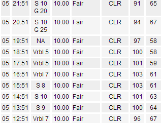
Back on Monday evening you can see the sea breeze in action according to hourly weather updates out of Camp Mabry. At 7 p.m. it was 100 with a dew point in the 50s with no wind. At 9 p.m. it was 94°F with a dew point in the upper 60s and a strong southerly wind (that was the sea breeze that moved through).