With this ridge of high pressure parked over our area, the air above us is forced to sink and compress. As the air compresses it heats up and dries out. During the afternoon hours, some of that dry air aloft is allowed to sink down to the surface. Therefore, allowing for temps to rapidly climb above the triple digit mark. Remember, the less moisture in the air, the easier it is for the air to cool off and heat up.
As the temperature rises and moves away from the dew point temperature, which is basically an indication of how much moisture is in the air, the humidity drops and eventually the dew point temperature will fall as well. Also important to keep in mind is that the higher the dew point temperature, the more muggy the air. When the dew point temperature and the air temperature meet up, the atmosphere becomes saturated, meaning humidity is at 100%. Therefore, fog develops.

Let's take yesterday for example...we started the day at a warm and muggy 79°F with a dew point temperature of 72°F which gave us a relative humidity of 79%...by early afternoon the temperature had already soared to 102°F with a dew point of 65°F...you can see the dew point has already fallen from earlier in the morning...that combination gave us a relative humidity of 30%...by 6 p.m. we were sizzling at 104°F with a dew point of 56°F which gave us a relatively low humidity at only 20%. See the key factor too remember is that as an air mass heats up, it is able to hold more moisture. That dry air aloft is actually a saving grace because it allows for moisture levels in the afternoon to drop. Even though the temperature was 104°F it actually felt "cooler" with a heat index of 103°F thanks to the dew points in the 50s. If the air had not dried out in the afternoon and we stayed with a muggy 72°F dew point while we were at 106°F yesterday afternoon our heat index would have soared to 118°F!! That would have felt more like the coastal cities in Saudi Arabia this time of year.
Due to the intense heating over central Texas our air pressure at the surface drops...remember, heat RISES, and RISING AIR produces LOW PRESSURE. Since water does not warm anywhere near as quickly as land, an area of higher surface pressure sets up over the Gulf of Mexico. High pressure always flows to low pressure, therefore, every summer evening after a very hot day, the winds crank up out of the south and southeast and replenish our area with sticky gulf air. Because air has been being lifted across central Texas all day due to the extreme heat, air over the gulf moves in to fill its place.

Take a look at today's latest high resolution forecast model dew point temperature analysis...the blues are dry air and the yellows and oranges are humid air. Watch how we start out muggy, dry out during the afternoon and end up muggy again overnight.

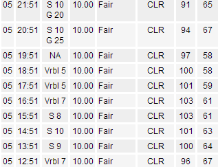
Back on Monday evening you can see the sea breeze in action according to hourly weather updates out of Camp Mabry. At 7 p.m. it was 100 with a dew point in the 50s with no wind. At 9 p.m. it was 94°F with a dew point in the upper 60s and a strong southerly wind (that was the sea breeze that moved through).
You bring up a good point on the effects of a sea breeze in your area. It's a thing of comfort off the cool Pacific in California, but quite another of discomfort off the warm Gulf! Glad that when your humidity makes it out here, our 4000' elevation cools it and with mountains, it can even become rain...
ReplyDelete