Good Evening Folks! It's another warm and breezy March afternoon across the area. Wednesday's official high temperatures are coming in at 83°F at both Camp Mabry and Austin Bergstrom International Airport. We started the day on a very mild note with temperatures in the mid to upper 60s.
An approaching upper level Pacific storm system (currently located along the west coast) is traveling east and will be increasing our chances for showers and thunderstorms across the area late Thursday into Friday. Ahead of Friday's storm chance, breezy southerly winds can be expected across central and south central Texas on Thursday. Southerly winds gusting 25-30 mph will be possible. Those southerly winds will be transporting plentiful amounts of Gulf of Mexico moisture into the area out ahead of Friday's showers and thunderstorms.
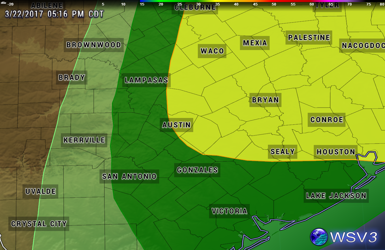
Friday Severe Weather Risk
Overall, the severe weather risk is looking to be fairly low for all of central Texas on Friday, however, one or two strong/potentially severe storms cannot be ruled out along and especially east of the I-35 corridor.
The Storm Prediction Center (SPC) has placed the area in the MARGINAL to SLIGHT Risk category for potential severe weather on Friday. The Marginal Risk area encompasses the eastern Hill Country down through San Antonio and to the Gulf Coast. The Slight Risk area encompasses areas from Austin to the north and east.
MARGINAL RISK = DARK GREEN SHADED AREA (5% risk of severe weather)
- Isolated severe thunderstorms possible (limited in duration and/or coverage/intensity)
- Low tornado risk
- Hail up to 1" in diameter (quarter-sized)
- Thunderstorm wind gusts of 40-60 mph
SLIGHT RISK = YELLOW SHADED AREA (15% risk of severe weather)
- Scattered severe storms possible (short-lived and/or not widespread, isolated intense storms possible)
- One or two tornadoes possible
- Reports of strong winds/wind damage possible
- Hail of about 1" in diameter possible, isolated 1.5-2" possible
Severe Weather Threat Map (valid late Thursday Night into Friday)
Storm Timeline
Per the latest forecast model guidance, a line of storms is likely to develop across west Texas late Thursday night and push east towards the I-35 corridor during the overnight hours. The high resolution North American Forecast Model has the line of storms moving through the:
- Hill Country between 4-9 a.m. CDT Friday morning and pushing
- through the I-35 corridor, including the Austin and San Antonio Metro Areas between 9-NOON CDT Friday
- and 1-5 p.m. CDT for areas east of Austin.
Forecast Radar 10 a.m. CDT Friday (shows a line of storms along the I-35 corridor from Dallas to San Antonio)

Forecast Rainfall Accumulation
Generally less than an inch for most, 0.25-0.50 is a good bet for most locations (especially along and east of the Highway 281 corridor)...higher totals east, lower totals west
After Friday's Storms
Showers and thunderstorms should come to an end along the I-35 corridor by early Friday afternoon with clearing skies expected from west to east during the afternoon hours, a weak cool front will move through the area late Friday night/early Saturday morning and usher in some slightly cooler and drier air into the area for the first half of the weekend...lows in the 50s expected early Saturday morning and again on Sunday morning with highs in the 80s...storm chances increase a bit Sunday night with another disturbance and again for the middle of next week. Plenty of time to watch that.
No comments:
Post a Comment