Saturday, January 28, 2017

Quiet, Pleasant Weather in our Future

Forecast Discussion

…quiet, calm weather pattern in store for central/south central Texas with warming trend to begin…

A dry northwest flow has developed across the area behind an upper level trough of low pressure that moved across the area yesterday evening/early Saturday morning. This northwest flow has ushered in a cool and very dry air mass.

Calm winds, clear skies, and dry air will allow for a very chilly night across the area tonight. Most locations across the area will wake up to temperatures in the 30s, a light freeze is likely in low-lying and out-lying locations.

A warming trend will begin taking shape as soon as Sunday afternoon when highs are forecast to rebound into the mid 60s to lower 70s across the area under a mostly sunny sky. Lows Sunday night will dip into the 30s and 40s area wide under a mainly clear sky.

Highs rebound into the 70s across the area by Monday afternoon as surface winds switch back out of the south southwest. Moisture will take a few days to return to the area, this under mostly sunny/clear skies will lead to mild, pleasant afternoons in the 70s and cool, chilly overnights in the 40s and 50s through the middle of next week. Shallow Gulf moisture expected to return by the middle of next week…this will add a bit more in the way of clouds to our sky and a general warming trend in overnight lows (less 40s, more 50s).

Rain chances possibly returning to the area by the end of next week. We still have plenty of time to monitor that.


Hope you all have a great rest of your weekend. Get out there and enjoy it, it’s going to be beautiful.

Monday, January 23, 2017

Record Warmth Likely Tuesday

Forecast Discussion
After a very windy end to the weekend, Monday proved to be a beautiful day across the area thanks to high pressure, dry air, and a light southerly breeze. While temperatures were running well above average for this time of year (it is January), it was hard to find anybody complaining. Official highs on Monday came in at 76ºF at Camp Mabry, Austin Bergstrom International Airport and San Antonio International Airport after starting the day on the chilly side in the 40s. 

The average high/low for this time of year in Austin is 62/42. The average high/low for this time of year in San Antonio is 63/41.

Record Warmth Likely Tuesday
Tuesday is going to be even WARMER, with many record highs in jeopardy. Temperatures should easily manage to climb into the upper 70s to middle 80s across the region, with the hottest temperatures in the state on Tuesday being felt across the Texas-Mexico border southwest of our area and south Texas. Afternoon highs in those areas are expected to soar into the upper 80s to middle 90s!

A dry southwesterly wind flow off of the Mexican Plateau will be responsible for the spike in temperatures on Tuesday ahead of an approaching upper level storm system that will pull a cold front into the area late Tuesday evening into early Wednesday morning. As air descends from the higher elevations of northern Mexico, it is forced to compress and in turn heat up. A southwest wind is notorious for bringing warm spells to our area (especially during the fall, spring, and winter months).

Tuesday’s Record Highs
Austin: 81ºF (2013)
Austin Bergstrom International Airport: 82ºF (1950)
San Antonio International Airport: 85ºF (1971)

HRRR Model Forecast Temperatures for Tuesday

Cooler, More Typical January Weather Arrives Wednesday
Highs and lows will drop to near/slightly below normal across the area beginning Wednesday behind the first in a series of cold fronts that will keep afternoon highs cool in the upper 50s/60s and overnight lows in the 30s through the end of the work week under mostly sunny/clear skies. A few sprinkles will be possible with the cold front early Wednesday morning (especially along and east of IH-35).  

Saturday, January 21, 2017

Windy Weather

Forecast Discussion
We officially topped out at a record-shattering 84ºF this afternoon at Austin Bergstrom International Airport, beating the previous record for this date of 81ºF set back in 1969. Camp Mabry topped out at 81ºF missing their record high of 82ºF set back in 1969 and 2003 by one degree. A southwest wind, dry air, and plentiful sunshine are to thank for today’s well above average warmth. 

A potent upper air disturbance and its associated surface cold front are helping to kick up some widely scattered showers and isolated thunderstorms across the area this evening…showers and an isolated thunderstorm will remain possible through the remainder of the evening. A Pacific cold front will move through the area later this evening, sweeping away the clouds, but really kicking up the winds out of the west northwest. 

Weather Alerts
The National Weather Service has issued a RED FLAG WARNING and a WIND ADVISORY for all of south central Texas in anticipation of Sunday’s blustery conditions. 

WIND ADVISORY goes into effect 9 a.m. Sunday morning and is set to expire at 6 p.m. Sunday evening. Sustained winds of 25-30 mph likely with gusts between 40-50 mph expected. Winds like this will make driving high profile vehicles difficult and may result in minor property damage. It is a good idea to secure any loose and/or lightweight outdoor furniture. 

RED FLAG WARNING in effect through early Sunday evening for high fire danger. Windy and dry conditions over the next 24 hours will be conducive for the rapid spread of wildfires, if one should start. Please use common sense.


Despite the windy conditions, Sunday will otherwise be a pleasant day with mostly sunny skies and pleasant temperatures in the upper 60s and lower 70s.  

Wednesday, January 18, 2017

Warmer, Drier, Sunnier End to the Week

Forecast Discussion
Over the past week, some very healthy rainfall has fallen across central and south central Texas. One final wave of energy will be moving across the area late tonight into Thursday morning. This wave will generate some additional rainfall tonight for areas generally south and east of the Austin Metro Area (especially along the coast). Some patchy fog is possible across all of the area tonight, especially in areas where clouds begin to clear away. Lows tonight will be dropping into the 40s and lower 50s tonight. Official highs today came in at 56°F at Camp Mabry, 57°F at Austin Bergstrom International Airport, and 65°F at San Antonio's International Airport (they saw more in the way of sunshine today).

HRRR Forecast Model Simulated Radar Image
(valid 2 a.m. CST Thursday morning)
Green = light rain
Yellows/Oranges = moderate rain


Past Week's Rainfall Totals (per the National Weather Service)
Camp Mabry: 3.60 inches
Austin Bergstrom International Airport: 3.15 inches
San Antonio International Airport: 2.44 inches

Past Week's Rainfall Totals (per the LCRA's Hydromet Network) 

I-35 corridor Locations:
Mansfield Dam (Lake Travis): 3.04 inches
Lago Vista: 1.66 inches
Bull Creek at Loop 360: 3.46 inches
Lady Bird Lake at Longhorn Dam: 4.65 inches
Barton Creek at Loop 360: 4.07 inches
Dripping Springs: 3.83 inches
Onion Creek at Buda: 3.59 inches

East of I-35:
Big Sandy Creek near Elgin: 2.97 inches
Colorado River at Bastrop: 2.44 inches
Cedar Creek: 2.38 inches
Colorado River at La Grange: 2.80 inches
Giddings: 3.29 inches

Hill Country: 
Burnet: 2.00 inches
Marble Falls: 1.97 inches
Blanco: 1.77 inches
Llano: 0.70 inches
Fredericksburg (10 miles WSW): 1.32 inches
Mason: 1.94 inches
San Saba: 1.21 inches

Thursday's Forecast
After some brief morning showers south and east of the Austin Metro Area skies will turn partly cloudy to mostly sunny across the area. A south southwesterly surface wind and plentiful sunshine will allow temperatures to soar into the 70s area wide Thursday afternoon.

Thursday Night 
Mostly clear & pleasantly cool around the area with lows dipping into the 40s and 50s. Some patchy fog cannot be ruled out in some locations.

Friday
Mostly to partly sunny and warm with highs in the 70s, perhaps near 80 in some locations. An isolated shower or storm cannot be ruled out for areas generally east of the I-35 corridor during the afternoon.

Saturday 
Partly sunny and warm with highs in the 70s, 20% chance for showers or storms

WINDY Sunday 
A windy storm system and its associated cold front will work across the area late Saturday night into Sunday morning and set us up for a breezy to windy and cool day. Northwest winds have the potential to be sustained between 15-30 mph with gusts as high as 40-45 mph possible. Highs only manage the 60s.

Sunday, January 15, 2017

Stormy Sunday

Forecast Discussion:
…shower/thunderstorm chances increasing…
…severe thunderstorms possible Sunday afternoon/evening across central Texas…

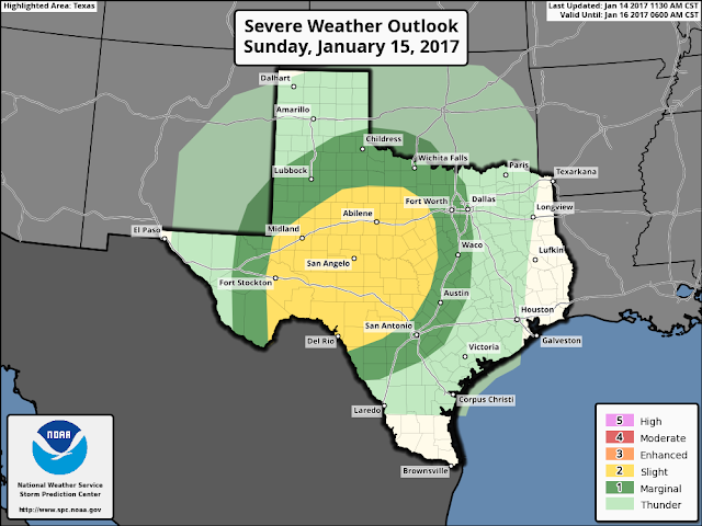
Storm Prediction Center Severe Weather Outlook (valid 6 a.m. Sunday morning through 6 a.m. Monday Morning)


 A dynamic upper level storm system, currently located over northwestern Mexico (south of Arizona), and an eastward moving Pacific Cold Front at the surface combined with Gulf of Mexico moisture will lead to increasing chances for showers and thunderstorms across the region Sunday/Sunday evening. Some of the storms that develop (especially along and west of the I-35 corridor) have the potential to become strong and/or severe with damaging winds, hail, and an isolated tornado being the primary threats. Heavy rainfall and deadly cloud to ground lightning will accompany the storms. Rainfall accumulation between 0.50 to 3.00 inches possible across the area. 

The wedge of shallow, cold air over us now will be forced to retreat north of the area by early Sunday afternoon thanks to the development of a stronger southerly surface wind developing in response to the approaching storm system. How far north this wedge of cool air goes is going to play a major role in determining if we will be seeing thunderstorms across the area late Sunday morning/early afternoon or rain showers. Latest forecast model guidance indicates the potential for two rounds of showers and storms across the area. The first coming late Sunday morning into early Sunday afternoon and another late Sunday afternoon/Sunday evening into the late evening hours. It looks like the second round of storms will be the one to really keep our eyes on for potential severe weather. There is the potential for a line of showers and storms (some potentially strong and/or severe) to approach the I-35 corridor from the west Sunday evening.

Forecast Radar (11 p.m. CST)  TX Tech WRF Hi-Res Model 


Severe Thunderstorm Definition:

Per the National Weather Service, a severe thunderstorm is a thunderstorm that produces one inch hail or larger in diameter and/or winds equal or exceed 58 miles an hour and/or a tornado.