Forecast Discussion
After soaring into the upper 60s to 70ºF today on breezy southerly winds this afternoon some minor changes are on the way to south central Texas. A relatively weak cold front for mid January is currently moving through the state of Texas as of the 9 p.m. hour. This front will move through the area with little fanfare overnight and allow for some cooler air to filter in on northerly winds. A few light rain showers will be possible along the front tonight with areas of patchy fog developing ahead of it.
Slightly Cooler Wednesday
>>>Wednesday will start cloudy and cool with temperatures in the 30s and 40s...sun breaks by afternoon and a returning east southeasterly wind will allow for temperatures to climb into the upper 50s to lower 60s by afternoon.
Breezy/Gusty Thursday
>>>Clouds and moisture stream back into the area late Wednesday into Thursday ahead of a stronger upper air disturbance and its associated surface cold front. A few light rain showers will be possible late Wednesday into early Thursday morning. Breezy west southwesterly winds Thursday morning will give way to gusty northwesterly winds by afternoon behind a cold front that will bring cooler air into the area. Thursday is NOT going to be a good day for allergy sufferers.
Cooler Friday, but less windy
>>>Cooler air filters into the area behind Thursday's cold front and drops highs into the 50s area wide Friday with overnight lows dropping into the upper 20s to mid 30s across the area Friday night into Saturday morning. Downtown Austin should stay a few degrees above freezing (32ºF), but low-lying, out-lying areas will likely receive a freeze.
Forecast Lows Friday Night (according to the GFS Forecast Model):
Image courtesy of Tropical Tidbits

Major East Coast Winter Storm This Weekend
>>>The weather system that crosses Texas on Thursday will then progress rapidly east and northeast to produce the first major Nor' Easter across the eastern seaboard. Wind, rain, snow, biting cold, it's all in the cards for the northeast/east coast this weekend.
GFS Forecast Precipitation/Sea Level Pressure for Saturday evening...the green is rain/the blue is snow...looks like snow will be flying across a good chunk of the northeastern United States and Mid-Atlantic:
Image courtesy of Tropical Tidbits

Early Weekend Outlook
>>>Warming trend takes us into the weekend with highs climbing back into the upper 50s and 60s and overnight lows coming back up into the 30s and 40s.
Long Range Outlook
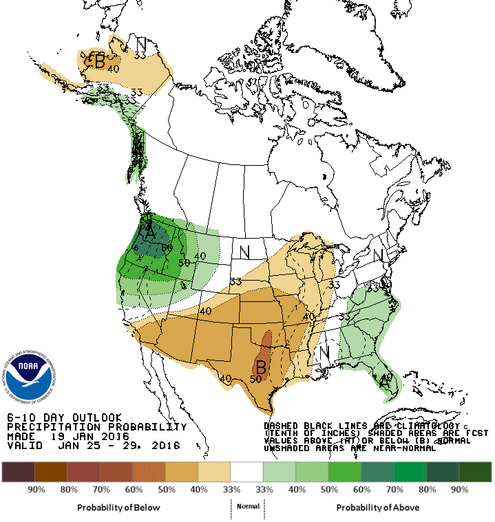
Long range outlook courtesy of the Climate Prediction Center valid for January 25th though 29th keeps temperatures warmer than normal for a good chunk of the central and western United States with a large portion of the the United States, including Texas, expecting below average rainfall. This is a very interesting outlook given that we are currently experiencing the strongest El Niño on record. El Niño TYPICALLY brings us cooler and wetter than normal conditions.
Colder/Wetter February?
Something keeps telling me that we are in for a colder and wetter February, but only time will tell. I would not be surprised to see some big weather surprises around here as we head into February/March. This is just a hunch I have. Only time will tell.
6-10 Day Temperature Outlook

6-10 Day Rainfall Outlook
No comments:
Post a Comment