Good evening everybody. What a crazy weather day today has been. We started the day off clear and cold with lows in the 20s and 30s area wide. This afternoon, thanks to warm southerly winds, we climbed to 70ºF here in Austin at Camp Mabry and 69ºF at the airport. We saw a 40 to 50 degree spread in temperature today! We started the day well below average and finished the day above average. Gotta love Texas!
The clouds really filled in across the area this afternoon thanks to an approaching Pacific Storm System which is currently affecting the southwestern United States right now. That storm system will continue tracking east towards Texas before turning off to the northeast. As that system nears Central Texas, our rain chances will be going up. Unfortunately, most of the rain that develops looks to be rather light which would end up not giving us much in the way of decent accumulation, however, as a Pacific Frontal boundary moves across the region tomorrow night, there is a slightly better chance for a more drenching shower or thundershower. Forecast models are indicating less than a half of an inch of rainfall for the entire area; that would be great if we even saw that. Of course, if you are under a heavier downpour you may pick up over a 1/2 inch of rain.
When putting a forecast together, I look at several different computer models. This go round, all of the models are pretty much singing the same tune. Which leads me to believe that this is not going to be a big deal, and on average, most of us will receive much less than a half an inch of rainfall which is very bad news for our worsening drought conditions.
We have a 40-50% chance for rain on Friday with a 30% chance for rain on Saturday. I hope you get some rain at your house.
The WRF Model out of Texas Tech University:
The NAM WRF HIGH RESOLUTION FORECAST MODEL:
GFS ACCUMULATED PRECIPITATION:
The very latest drought monitor issued just this morning has placed all of Central Texas in the SEVERE drought category...nearly 95% of the state is experiencing drought conditions. Unfortunately, long range forecasts provided by the Climate Prediction Center indicate that the drought is likely to persist and worsen over the coming months.
The Climate Prediction Center is forecasting much above average temperatures and much below normal rainfall conditions over the next 6-10 days. Our next big cool down and our next freeze looks to come around Christmas.
Thursday, December 13, 2012
Sunday, December 9, 2012
HARD FREEZE ON THE WAY
As of writing this post, we are down to 57ºF here in Austin at Camp Mabry with a north wind at 8 mph gusting to 20 mph. We are already down some 20-25 degrees across the area from this afternoon's high temperature of 80ºF here in Austin (which only missed the record high for today by one degree).
Current conditions across Texas as of 10 P.M. CST Sunday, December 9, 2012
Amarillo: 21ºF with light snow falling (wind chill is in the single digits)
Lubbock: 28ºF (wind chill is in the teens)
Dallas: 48ºF (wind chill in the lower 40s)
San Angelo: 46ºF (wind chill in the upper 30s)
Austin: 57ºF
San Antonio: 69ºF
Laredo: 70ºF
As you can see, the leading edge of the cooler air is just pushing into Central Texas now...much colder and windier conditions will arrive overnight tonight as the true Arctic Air pours into our area.
Models continue to show a light dusting of snow for northwest Texas and southern Oklahoma by Monday morning.
Tonight's Forecast: Temps in the 50s and 60s now will plummet into the 30s overnight as the second surge of cold Arctic air moves into the area on strong north northwesterly winds. Wind chills will be in the 20s by morning. Make sure to bundle up as you leave for school or work as it will definitely be a shock to the system for us. Keep in mind, we have been dealing with temps in the 70s and 80s for a good while now.
COLD BLAST TIMELINE:
Monday Morning: We will wake up to temps in the 30s across Central Texas with strong northerly winds putting wind chills down into the 20s. Northwestern portions of Central Texas may receive a light freeze.
Monday Afternoon: Cold and blustery with temps staying in the 40s for a good chunk of the day, southern portions of central Texas may make it to 50 degrees.
Monday Night: With clear skies, light winds, cold Polar High overhead, and very dry air in place, Central Texas is in for a widespread freeze. Lows will drop into the middle to upper 20s right here in Austin with lows in the lower 20s expected across out-lying and low-lying areas of Central Texas. In fact, some of the coldest spots across Central Texas may dip into the teens by Tuesday morning. BRR!
The Texas Panhandle will dip into the single digits and teens tomorrow night with widespread 20s expected across the Lone Star State...even the coast will be dipping into the 30s!
Current conditions across Texas as of 10 P.M. CST Sunday, December 9, 2012
Amarillo: 21ºF with light snow falling (wind chill is in the single digits)
Lubbock: 28ºF (wind chill is in the teens)
Dallas: 48ºF (wind chill in the lower 40s)
San Angelo: 46ºF (wind chill in the upper 30s)
Austin: 57ºF
San Antonio: 69ºF
Laredo: 70ºF
As you can see, the leading edge of the cooler air is just pushing into Central Texas now...much colder and windier conditions will arrive overnight tonight as the true Arctic Air pours into our area.
Models continue to show a light dusting of snow for northwest Texas and southern Oklahoma by Monday morning.
Tonight's Forecast: Temps in the 50s and 60s now will plummet into the 30s overnight as the second surge of cold Arctic air moves into the area on strong north northwesterly winds. Wind chills will be in the 20s by morning. Make sure to bundle up as you leave for school or work as it will definitely be a shock to the system for us. Keep in mind, we have been dealing with temps in the 70s and 80s for a good while now.
COLD BLAST TIMELINE:
Monday Morning: We will wake up to temps in the 30s across Central Texas with strong northerly winds putting wind chills down into the 20s. Northwestern portions of Central Texas may receive a light freeze.
Monday Afternoon: Cold and blustery with temps staying in the 40s for a good chunk of the day, southern portions of central Texas may make it to 50 degrees.
Monday Night: With clear skies, light winds, cold Polar High overhead, and very dry air in place, Central Texas is in for a widespread freeze. Lows will drop into the middle to upper 20s right here in Austin with lows in the lower 20s expected across out-lying and low-lying areas of Central Texas. In fact, some of the coldest spots across Central Texas may dip into the teens by Tuesday morning. BRR!
Friday, December 7, 2012
COLD BLAST ON THE WAY!
Hello everybody. Despite all of the clouds and fog across the area this morning, highs still managed to climb into the 70s across the area. We officially topped out at 79°F in Austin this afternoon at Camp Mabry...nearly 15 degrees above average for this time of year. Believe it or not, by Monday we will be running some 15 degrees cooler than average for this time of year.
A taste of Arctic Air is on the way to Texas and will arrive in Austin Sunday evening with a possible line of showers and thunderstorms. The best chance for showers and storms will be along and east of the Interstate 35 corridor where there will be more moisture in the air. Computer models are estimating anywhere from a trace to 0.25 inches of rainfall for areas along Interstate 35 (including the Austin Metro Area)...areas east of Interstate 35 may receive as much as 0.70 inches of rainfall Sunday night along the front.
Weekend Forecast:
Saturday: Cloudy, foggy, and drizzly start to the day in the 60s will give way to a partly sunny and warm afternoon with temps climbing into the upper 70s to near 80°F in a few spots.
Saturday Night: Clouds roll in once again with areas of fog and drizzle developing after midnight...lows will only drop into the 60s
Sunday: Cloudy, drizzly, and foggy start will give way to a mostly cloudy and warm afternoon with temps in the upper 70s. Front will begin pushing in to the northwestern Hill Country mid-afternoon, blowing into the Austin Area during the evening with a possible line of showers and thunderstorms. Temps will fall from the 70s Sunday afternoon into the 30s Monday morning on a strong northerly wind between 15-25 mph...winds will gust as high as 35 mph at times. There is a 50% chance for showers and storms along and ahead of the front.
Highs on Monday will struggle to get out of the 40s on a strong northerly breeze...Monday night all of Central Texas looks to receive a freeze *INCLUDING THE AUSTIN METRO AREA* temps will fall into the 29-32°F range in urban areas with temps in the 20-25°F range across low spots (areas near or in creek/stream valleys).
Another freeze is possible Tuesday night for Austin with a freeze likely for outlying areas.
*High resolution NAM Computer Model is forecasting a line of storms to develop just as the front passes Austin and moves into southeastern portions of south Central Texas...check out the gray, blue, white, and red across the Texas Panhandle and New Mexico...that is SNOW!*
GFS MODEL SHOWING RAINFALL ACCUMULATION ON SUNDAY WITH THE FRONT
A taste of Arctic Air is on the way to Texas and will arrive in Austin Sunday evening with a possible line of showers and thunderstorms. The best chance for showers and storms will be along and east of the Interstate 35 corridor where there will be more moisture in the air. Computer models are estimating anywhere from a trace to 0.25 inches of rainfall for areas along Interstate 35 (including the Austin Metro Area)...areas east of Interstate 35 may receive as much as 0.70 inches of rainfall Sunday night along the front.
Weekend Forecast:
Saturday: Cloudy, foggy, and drizzly start to the day in the 60s will give way to a partly sunny and warm afternoon with temps climbing into the upper 70s to near 80°F in a few spots.
Saturday Night: Clouds roll in once again with areas of fog and drizzle developing after midnight...lows will only drop into the 60s
Sunday: Cloudy, drizzly, and foggy start will give way to a mostly cloudy and warm afternoon with temps in the upper 70s. Front will begin pushing in to the northwestern Hill Country mid-afternoon, blowing into the Austin Area during the evening with a possible line of showers and thunderstorms. Temps will fall from the 70s Sunday afternoon into the 30s Monday morning on a strong northerly wind between 15-25 mph...winds will gust as high as 35 mph at times. There is a 50% chance for showers and storms along and ahead of the front.
Highs on Monday will struggle to get out of the 40s on a strong northerly breeze...Monday night all of Central Texas looks to receive a freeze *INCLUDING THE AUSTIN METRO AREA* temps will fall into the 29-32°F range in urban areas with temps in the 20-25°F range across low spots (areas near or in creek/stream valleys).
Another freeze is possible Tuesday night for Austin with a freeze likely for outlying areas.
*High resolution NAM Computer Model is forecasting a line of storms to develop just as the front passes Austin and moves into southeastern portions of south Central Texas...check out the gray, blue, white, and red across the Texas Panhandle and New Mexico...that is SNOW!*
GFS MODEL SHOWING RAINFALL ACCUMULATION ON SUNDAY WITH THE FRONT
Wednesday, December 5, 2012
BIG COLD FRONT ON THE WAY!
Well we officially climbed to 74°F this afternoon in Austin after waking up on the cool side this morning with temperatures in the 40s and 50s. Over the next several days temps will continue to come up. We will be close to 80°F by Saturday afternoon. However, BIG CHANGES arrive on Sunday with the arrival of a strong cold front.
Short Term Forecast:
Tonight: Mostly clear and cool with lows dipping into the 40s and 50s; some patchy fog is possible in spots well after midnight.
Thursday: Mostly sunny and warm with a high near 75°F...southerly breeze returns between 5-15 mph
Thursday Night: Increasing clouds and cool with a low in the mid 50s; fog and drizzle possible after midnight.
Friday: Fog and drizzle to start the day will give way to a mostly cloudy and warm afternoon with a high near 78°F
Friday Night: Low clouds with areas of fog and drizzle return to the area. Lows only fall to near 60°F
Saturday: Cloudy start gives way to partly sunny and warm afternoon with highs in the upper 70s to near 80°F
Sunday: THE COLD BLAST ARRIVES
IN-DEPTH ANALYSIS:
Computer models are coming into agreement that the much-anticipated cold front will arrive Sunday afternoon between 2-5 p.m. here in the Austin area. You will know when the front arrives as winds will abruptly shift to the north northwest and blow hard between 15-30 mph temps will drop from the 70s into the 50s by evening with temps falling into the upper 30s by Monday morning with wind chills in the 20s expected.. There is about a 30% chance for showers or thunderstorms with the front, however, best rainfall chances look to be along and east of the Interstate 35 corridor. Anything that develops will be moving so quickly with the front that it will not have a sufficient time to produce good rainfall totals.
BELOW IS A LOOK AT GFS COMPUTER MODEL SNAPSHOTS:
SUNDAY AFTERNOON: Front pushing into Central Texas indicated by the abrupt change in wind speed and temperature.
MONDAY MORNING: Temps will be in the mid to upper 30s across central Texas with winds blowing out of the north putting wind chills down into the 20s!!!
MONDAY AFTERNOON: Temps will have a tough time climbing out of the 40s; we may be able to sneak into the lower 50s at best with a brisk northerly wind.
MONDAY NIGHT: Clear and COLD with temps falling into the lower 30s across the area. Some low spots may dip into the 20s.
And get this, latest computer model runs are showing another blast of cold air moving into Central Texas on Friday of next week! COLD WEATHER FANS REJOICE!!!
Short Term Forecast:
Tonight: Mostly clear and cool with lows dipping into the 40s and 50s; some patchy fog is possible in spots well after midnight.
Thursday: Mostly sunny and warm with a high near 75°F...southerly breeze returns between 5-15 mph
Thursday Night: Increasing clouds and cool with a low in the mid 50s; fog and drizzle possible after midnight.
Friday: Fog and drizzle to start the day will give way to a mostly cloudy and warm afternoon with a high near 78°F
Friday Night: Low clouds with areas of fog and drizzle return to the area. Lows only fall to near 60°F
Saturday: Cloudy start gives way to partly sunny and warm afternoon with highs in the upper 70s to near 80°F
Sunday: THE COLD BLAST ARRIVES
IN-DEPTH ANALYSIS:
Computer models are coming into agreement that the much-anticipated cold front will arrive Sunday afternoon between 2-5 p.m. here in the Austin area. You will know when the front arrives as winds will abruptly shift to the north northwest and blow hard between 15-30 mph temps will drop from the 70s into the 50s by evening with temps falling into the upper 30s by Monday morning with wind chills in the 20s expected.. There is about a 30% chance for showers or thunderstorms with the front, however, best rainfall chances look to be along and east of the Interstate 35 corridor. Anything that develops will be moving so quickly with the front that it will not have a sufficient time to produce good rainfall totals.
BELOW IS A LOOK AT GFS COMPUTER MODEL SNAPSHOTS:
SUNDAY AFTERNOON: Front pushing into Central Texas indicated by the abrupt change in wind speed and temperature.
MONDAY MORNING: Temps will be in the mid to upper 30s across central Texas with winds blowing out of the north putting wind chills down into the 20s!!!
MONDAY AFTERNOON: Temps will have a tough time climbing out of the 40s; we may be able to sneak into the lower 50s at best with a brisk northerly wind.
MONDAY NIGHT: Clear and COLD with temps falling into the lower 30s across the area. Some low spots may dip into the 20s.
And get this, latest computer model runs are showing another blast of cold air moving into Central Texas on Friday of next week! COLD WEATHER FANS REJOICE!!!
Monday, December 3, 2012
ARCTIC BLAST NEXT WEEK!!!
I know what you are all thinking, where's winter? What's with our long stretch of spring-like weather? When is it coming to an end? Over the next week we will continue to deal with above normal temperatures in the 70s to near 80°F. In fact, we topped out at 80°F this afternoon at Camp Mabry and 81°F at the airport. The average high for this time of year in Austin is 65°F, so you can clearly see we were some 15°F above average this afternoon. In fact, our low this morning is more in line with where afternoon highs should be! Crazy!
Here's a look at 4 PM temperatures across the state of Texas: Check out all of those reds and oranges indicating temperatures in the 70s and 80s
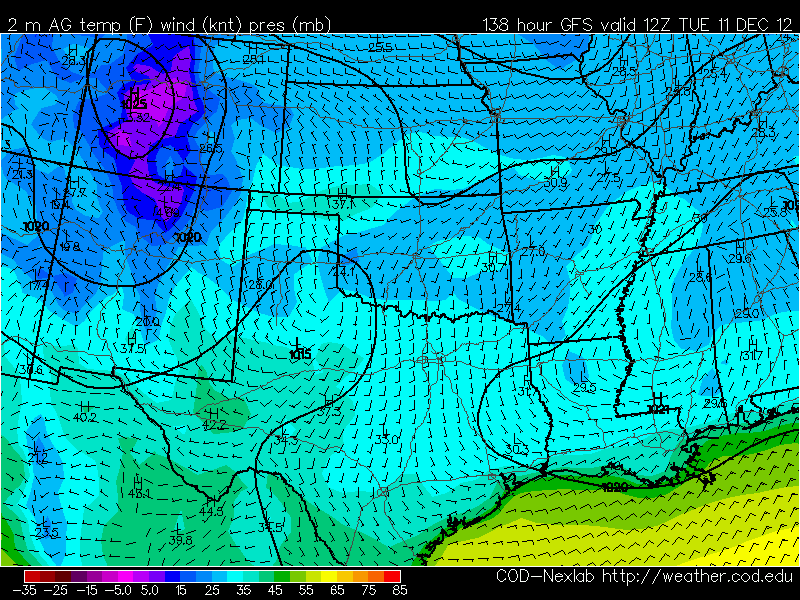
Well, I have got some great news for all of you cold weather lovers (including myself)...computer models have been consistently predicting a strong Arctic Front to blow into the state of Texas next Monday. In fact, the source of this cold air is across northwest Canada and Alaska where temps are nearing 50 DEGREES BELOW ZERO...of course that air will be greatly modified by the time it reaches our neck of the woods, however, we are still talking about the possibility of highs in the 40s and 50s for a good chunk of next week with overnight lows in the 20s and 30s. In fact, it looks like Austin will get its first official freeze of the season next week.
IMAGE BELOW: ECMWF (European Forecast Model) puts temps into the 80s to near 90 across south Texas for next Monday with temps only in the 30s across the Panhandle! Gotta love Texas!
The image above shows temps plunging into the lower 30s across all of Central Texas with temps in the 10s and 20s across north Texas and the Texas Panhandle.
Will there be any rainfall with the front, the answer is maybe. Would there be a lot of rainfall with the front? Unfortunately, no. The front will be moving so quickly that any rainfall that manages to come through the area would be moving so quickly that it would not be able to amount to much. Models show some rainfall with the front and are actually predicting snow for the Texas Panhandle, northwest Texas, and Oklahoma for next Monday night/Tuesday. WOW! What a change from temps in the 70s and 80s. The front will really crank up the winds for next week with winds gusting as high as 40 mph with the arrival of the front.
Of course, this is a week away, therefore, things are likely to change, however, it is beginning to look like we are in for a pretty good cold snap next week which will drop highs and lows well BELOW AVERAGE for this time of year.
Here's a look at 4 PM temperatures across the state of Texas: Check out all of those reds and oranges indicating temperatures in the 70s and 80s
Well, I have got some great news for all of you cold weather lovers (including myself)...computer models have been consistently predicting a strong Arctic Front to blow into the state of Texas next Monday. In fact, the source of this cold air is across northwest Canada and Alaska where temps are nearing 50 DEGREES BELOW ZERO...of course that air will be greatly modified by the time it reaches our neck of the woods, however, we are still talking about the possibility of highs in the 40s and 50s for a good chunk of next week with overnight lows in the 20s and 30s. In fact, it looks like Austin will get its first official freeze of the season next week.
IMAGE BELOW: ECMWF (European Forecast Model) puts temps into the 80s to near 90 across south Texas for next Monday with temps only in the 30s across the Panhandle! Gotta love Texas!
The image above shows temps plunging into the lower 30s across all of Central Texas with temps in the 10s and 20s across north Texas and the Texas Panhandle.
Will there be any rainfall with the front, the answer is maybe. Would there be a lot of rainfall with the front? Unfortunately, no. The front will be moving so quickly that any rainfall that manages to come through the area would be moving so quickly that it would not be able to amount to much. Models show some rainfall with the front and are actually predicting snow for the Texas Panhandle, northwest Texas, and Oklahoma for next Monday night/Tuesday. WOW! What a change from temps in the 70s and 80s. The front will really crank up the winds for next week with winds gusting as high as 40 mph with the arrival of the front.
Of course, this is a week away, therefore, things are likely to change, however, it is beginning to look like we are in for a pretty good cold snap next week which will drop highs and lows well BELOW AVERAGE for this time of year.
Sunday, December 2, 2012
More 80s for Sunday and Monday
We officially set two brand new record highs on Saturday at both Camp Mabry and ABIA (Austin Bergstrom International Airport).
NEW ALL-TIME RECORD HIGHS FOR DECEMBER 1st:
Camp Mabry: 83ºF (Old record high was 82ºF set back in 1954)
ABIA: 84ºF (Old record high was 83ºF set back in 1954)
Keep in mind, the "normal" high for this time of year is 66ºF
IMAGE ABOVE IS A LOOK AT OFFICIAL HIGHS FROM ACROSS CENTRAL TEXAS FOR 12/1/12
Forecast models show another very warm December day for all of Texas again on Sunday. Here's a look at the latest high resolution NAM Model:
NEW ALL-TIME RECORD HIGHS FOR DECEMBER 1st:
Camp Mabry: 83ºF (Old record high was 82ºF set back in 1954)
ABIA: 84ºF (Old record high was 83ºF set back in 1954)
Keep in mind, the "normal" high for this time of year is 66ºF
IMAGE ABOVE IS A LOOK AT OFFICIAL HIGHS FROM ACROSS CENTRAL TEXAS FOR 12/1/12
Forecast models show another very warm December day for all of Texas again on Sunday. Here's a look at the latest high resolution NAM Model:
Friday, November 30, 2012
Where's the COLD AIR?
Take a look at the latest NAM High Resolution Temperature Model for Texas. Both the NAM & GFS models put Austin at 83°F for Saturday, 80°F on Sunday, and 81°F on Monday to start off the new week. Keep in mind the average high for this time of year is only 64°F (so you can clearly see we are going to be well above average through the weekend and into next week)
So, where is all of the cold air? It is stuck and building across Canada and Alaska. In fact, temps are at -40°F across portions of the Yukon Territory and Alaska. A piece of that cold air looks to break loose the middle of next week and arrive in Austin next Saturday (December 8th)...of course, the air will be modified by the time it reaches Central Texas. I think this front has the potential to take highs down into the 40s and 50s with overnight lows dropping into the 20s and 30s across the area. Until then, above normal and drier than normal weather will persist.
Latest forecast models are indicating that a line of showers and thunderstorms may accompany the front next weekend. Right now it is early to say just how much rainfall we are likely to receive, however, the GFS is indicating that between today through December 8th we may receive anywhere from 0.40 to 1 inch of rain. Keep your fingers crossed.
This is a look at forecasted rainfall totals across the lower 48 from today through next Saturday.
Subscribe to:
Posts (Atom)